Event submissions
Events1st International Online Conference on Agriculture - Advances in Agricultural Science and Technology
Published

This submission belongs to the session 14. Poster Session of the event 1st International Online Conference on Agriculture - Advances in Agricultural Science and Technology
Published date
11 Feb, 2022
Academic Editor
'%3e%3cpath%20d='M12.6657%2010.9104C12.4185%2010.325%2012.0599%209.79327%2011.6097%209.34482C11.1609%208.89508%2010.6293%208.5365%2010.0442%208.28888C10.0389%208.28626%2010.0337%208.28495%2010.0285%208.28233C10.8446%207.69279%2011.3752%206.73249%2011.3752%205.64904C11.3752%203.8542%209.92103%202.39999%208.1262%202.39999C6.33136%202.39999%204.87715%203.8542%204.87715%205.64904C4.87715%206.73249%205.40774%207.69279%206.22393%208.28364C6.21869%208.28626%206.21345%208.28757%206.20821%208.29019C5.62129%208.5378%205.09463%208.89284%204.64265%209.34613C4.1929%209.79493%203.83432%2010.3266%203.58671%2010.9117C3.34345%2011.4845%203.21226%2012.0987%203.20023%2012.7209C3.19988%2012.7349%203.20233%2012.7488%203.20744%2012.7619C3.21255%2012.7749%203.22022%2012.7867%203.22998%2012.7968C3.23975%2012.8068%203.25142%2012.8147%203.26431%2012.8202C3.2772%2012.8256%203.29105%2012.8284%203.30504%2012.8284H4.09109C4.14874%2012.8284%204.19459%2012.7825%204.1959%2012.7262C4.2221%2011.7148%204.62823%2010.7676%205.34617%2010.0497C6.08899%209.30683%207.0755%208.89808%208.1262%208.89808C9.17689%208.89808%2010.1634%209.30683%2010.9062%2010.0497C11.6242%2010.7676%2012.0303%2011.7148%2012.0565%2012.7262C12.0578%2012.7838%2012.1037%2012.8284%2012.1613%2012.8284H12.9474C12.9613%2012.8284%2012.9752%2012.8256%2012.9881%2012.8202C13.001%2012.8147%2013.0126%2012.8068%2013.0224%2012.7968C13.0322%2012.7867%2013.0398%2012.7749%2013.0449%2012.7619C13.0501%2012.7488%2013.0525%2012.7349%2013.0522%2012.7209C13.0391%2012.0947%2012.9094%2011.4855%2012.6657%2010.9104ZM8.1262%207.9024C7.52486%207.9024%206.9589%207.6679%206.53312%207.24211C6.10733%206.81633%205.87283%206.25037%205.87283%205.64904C5.87283%205.0477%206.10733%204.48174%206.53312%204.05596C6.9589%203.63018%207.52486%203.39567%208.1262%203.39567C8.72753%203.39567%209.29349%203.63018%209.71927%204.05596C10.1451%204.48174%2010.3796%205.0477%2010.3796%205.64904C10.3796%206.25037%2010.1451%206.81633%209.71927%207.24211C9.29349%207.6679%208.72753%207.9024%208.1262%207.9024Z'%20fill='%235D1EE1'/%3e%3c/g%3e%3c/svg%3e) Bin Gao
Bin GaoCitation
Diego Gallinelli, Giuseppe Pulighe, Davide Rizzi, Flavio Lupia, Reusability of IACS/LPIS geospatial data to estimate the Utilized Agricultural Area, in Proceedings of 1st International Online Conference on Agriculture - Advances in Agricultural Science and Technology, 10 February–25 February 2022, MDPI: Basel, Switzerland, doi: 10.3390/IOCAG2022-12241
Share
Email
Facebook
Twitter
LinkedIn
Reusability of IACS/LPIS geospatial data to estimate the Utilized Agricultural Area
'%3e%3cpath%20d='M12.6647%2010.9104C12.4176%2010.325%2012.0589%209.7933%2011.6088%209.34485C11.16%208.89511%2010.6283%208.53653%2010.0432%208.28891C10.038%208.28629%2010.0327%208.28498%2010.0275%208.28236C10.8437%207.69282%2011.3743%206.73252%2011.3743%205.64907C11.3743%203.85423%209.92005%202.40002%208.12522%202.40002C6.33038%202.40002%204.87618%203.85423%204.87618%205.64907C4.87618%206.73252%205.40677%207.69282%206.22296%208.28367C6.21772%208.28629%206.21248%208.2876%206.20724%208.29022C5.62031%208.53783%205.09365%208.89287%204.64167%209.34616C4.19192%209.79496%203.83334%2010.3266%203.58573%2010.9117C3.34247%2011.4846%203.21128%2012.0987%203.19925%2012.721C3.1989%2012.735%203.20135%2012.7489%203.20646%2012.7619C3.21157%2012.7749%203.21924%2012.7868%203.22901%2012.7968C3.23877%2012.8068%203.25045%2012.8148%203.26334%2012.8202C3.27623%2012.8256%203.29007%2012.8284%203.30406%2012.8284H4.09012C4.14776%2012.8284%204.19362%2012.7825%204.19493%2012.7262C4.22113%2011.7148%204.62726%2010.7676%205.34519%2010.0497C6.08802%209.30686%207.07452%208.89811%208.12522%208.89811C9.17592%208.89811%2010.1624%209.30686%2010.9052%2010.0497C11.6232%2010.7676%2012.0293%2011.7148%2012.0555%2012.7262C12.0568%2012.7839%2012.1027%2012.8284%2012.1603%2012.8284H12.9464C12.9604%2012.8284%2012.9742%2012.8256%2012.9871%2012.8202C13%2012.8148%2013.0117%2012.8068%2013.0214%2012.7968C13.0312%2012.7868%2013.0389%2012.7749%2013.044%2012.7619C13.0491%2012.7489%2013.0515%2012.735%2013.0512%2012.721C13.0381%2012.0947%2012.9084%2011.4856%2012.6647%2010.9104ZM8.12522%207.90243C7.52388%207.90243%206.95792%207.66793%206.53214%207.24215C6.10636%206.81636%205.87185%206.2504%205.87185%205.64907C5.87185%205.04773%206.10636%204.48177%206.53214%204.05599C6.95792%203.63021%207.52388%203.3957%208.12522%203.3957C8.72655%203.3957%209.29252%203.63021%209.7183%204.05599C10.1441%204.48177%2010.3786%205.04773%2010.3786%205.64907C10.3786%206.2504%2010.1441%206.81636%209.7183%207.24215C9.29252%207.66793%208.72655%207.90243%208.12522%207.90243Z'%20fill='%235D1EE1'/%3e%3c/g%3e%3c/svg%3e)
Diego Gallinelli 1
Giuseppe Pulighe 1
Davide Rizzi 2
Flavio Lupia 1
1. CREA -Centro di ricerca Politiche e Bioeconomia
2. SIN S.p.A. - Sistema Informativo Nazionale per lo sviluppo dell’agricoltura
Abstract
Recently, the EU Commission promoted the opening and reusing of administrative data managed within the Integrated Administration and Control Systems (IACS) from European paying agencies as useful tool for monitoring Common Agricultural Policy (CAP) performances (Directive (EU) 2019/1024). In this scenario, the Open IACS project aims to process these data to compute statistical indicators for agri-environmental analysis, assess the CAP performances and support farmer activities and decision making.
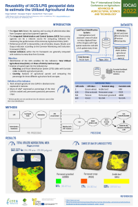
This work shows processing and harmonization steps required to generate statistical data and geographical layers of the Utilized Agricultural Area (UAA) and share of UAA by land use types in Italy. The latter are defined as context indicators within the EU framework for assessing CAP performances and are generally computed with statistical surveys from Eurostat. We used the Land Parcel Information System (LPIS) dataset from the Italian Paying Agency (AGEA) consisting of homogeneous land use/cover areas of Italian territory digitized from ortho-imagery with high spatial resolution and with a full update every three years. In particular, LPIS provides detailed information about spatial location, identification and quantification of agricultural, natural and artificial land. It represents a huge step forward land use studies capable of making in-depth analyses from national to municipality scale, even to the agricultural parcel. Moreover, the availability of land use maps with a high spatial resolution of crops types meets the need to guarantee a more accurate view about the complexity of landscapes useful to carry out different agri-environmental analyses (crop production, eco-hydrological modelling, soil consumption, surface runoff, etc.). Lastly, the results of indicators can be compared to agricultural statistical survey of National Institutes and greatly improving European current land data with lower spatial-temporal resolution and oversimplification of land use classes (e.g. Corine Land Cover – CLC).
Keywords
agricultural land use
common agricultural policy
open data
Manuscript
manuscript_Gallinelli.pdf
Poster
IOCAG22_Poster.pdf
Smart weather data management based on big data analytics and artificial intelligence
Prediction of bread-baking quality parameters for commercial Romanian wheat genotypes using near infrared spectroscopy