Event submissions
Published
This submission belongs to the session S6. Water Resources Management, Floods and Risk Mitigation of the event The 8th International Electronic Conference on Water Sciences
Published date
14 Oct, 2024
Academic Editor
'%3e%3cpath%20d='M12.6657%2010.9104C12.4185%2010.325%2012.0599%209.79327%2011.6097%209.34482C11.1609%208.89508%2010.6293%208.5365%2010.0442%208.28888C10.0389%208.28626%2010.0337%208.28495%2010.0285%208.28233C10.8446%207.69279%2011.3752%206.73249%2011.3752%205.64904C11.3752%203.8542%209.92103%202.39999%208.1262%202.39999C6.33136%202.39999%204.87715%203.8542%204.87715%205.64904C4.87715%206.73249%205.40774%207.69279%206.22393%208.28364C6.21869%208.28626%206.21345%208.28757%206.20821%208.29019C5.62129%208.5378%205.09463%208.89284%204.64265%209.34613C4.1929%209.79493%203.83432%2010.3266%203.58671%2010.9117C3.34345%2011.4845%203.21226%2012.0987%203.20023%2012.7209C3.19988%2012.7349%203.20233%2012.7488%203.20744%2012.7619C3.21255%2012.7749%203.22022%2012.7867%203.22998%2012.7968C3.23975%2012.8068%203.25142%2012.8147%203.26431%2012.8202C3.2772%2012.8256%203.29105%2012.8284%203.30504%2012.8284H4.09109C4.14874%2012.8284%204.19459%2012.7825%204.1959%2012.7262C4.2221%2011.7148%204.62823%2010.7676%205.34617%2010.0497C6.08899%209.30683%207.0755%208.89808%208.1262%208.89808C9.17689%208.89808%2010.1634%209.30683%2010.9062%2010.0497C11.6242%2010.7676%2012.0303%2011.7148%2012.0565%2012.7262C12.0578%2012.7838%2012.1037%2012.8284%2012.1613%2012.8284H12.9474C12.9613%2012.8284%2012.9752%2012.8256%2012.9881%2012.8202C13.001%2012.8147%2013.0126%2012.8068%2013.0224%2012.7968C13.0322%2012.7867%2013.0398%2012.7749%2013.0449%2012.7619C13.0501%2012.7488%2013.0525%2012.7349%2013.0522%2012.7209C13.0391%2012.0947%2012.9094%2011.4855%2012.6657%2010.9104ZM8.1262%207.9024C7.52486%207.9024%206.9589%207.6679%206.53312%207.24211C6.10733%206.81633%205.87283%206.25037%205.87283%205.64904C5.87283%205.0477%206.10733%204.48174%206.53312%204.05596C6.9589%203.63018%207.52486%203.39567%208.1262%203.39567C8.72753%203.39567%209.29349%203.63018%209.71927%204.05596C10.1451%204.48174%2010.3796%205.0477%2010.3796%205.64904C10.3796%206.25037%2010.1451%206.81633%209.71927%207.24211C9.29349%207.6679%208.72753%207.9024%208.1262%207.9024Z'%20fill='%235D1EE1'/%3e%3c/g%3e%3c/svg%3e) ATHANASIOS LOUKAS
ATHANASIOS LOUKASCitation
Eleni A. Tzanou, Anastasia I. Triantafyllou, Dimitrios A. Natsiopoulos, Dimitrios Ramnalis, Georgios S. Vergos, Correlation between hydraulic analysis and spatially distributed topographic index modelling for flood risk mapping, in Proceedings of The 8th International Electronic Conference on Water Sciences, 14 October–16 October 2024, MDPI: Basel, Switzerland
Share
Email
Facebook
Twitter
LinkedIn
Correlation between hydraulic analysis and spatially distributed topographic index modelling for flood risk mapping
'%3e%3cpath%20d='M12.6647%2010.9104C12.4176%2010.325%2012.0589%209.7933%2011.6088%209.34485C11.16%208.89511%2010.6283%208.53653%2010.0432%208.28891C10.038%208.28629%2010.0327%208.28498%2010.0275%208.28236C10.8437%207.69282%2011.3743%206.73252%2011.3743%205.64907C11.3743%203.85423%209.92005%202.40002%208.12522%202.40002C6.33038%202.40002%204.87618%203.85423%204.87618%205.64907C4.87618%206.73252%205.40677%207.69282%206.22296%208.28367C6.21772%208.28629%206.21248%208.2876%206.20724%208.29022C5.62031%208.53783%205.09365%208.89287%204.64167%209.34616C4.19192%209.79496%203.83334%2010.3266%203.58573%2010.9117C3.34247%2011.4846%203.21128%2012.0987%203.19925%2012.721C3.1989%2012.735%203.20135%2012.7489%203.20646%2012.7619C3.21157%2012.7749%203.21924%2012.7868%203.22901%2012.7968C3.23877%2012.8068%203.25045%2012.8148%203.26334%2012.8202C3.27623%2012.8256%203.29007%2012.8284%203.30406%2012.8284H4.09012C4.14776%2012.8284%204.19362%2012.7825%204.19493%2012.7262C4.22113%2011.7148%204.62726%2010.7676%205.34519%2010.0497C6.08802%209.30686%207.07452%208.89811%208.12522%208.89811C9.17592%208.89811%2010.1624%209.30686%2010.9052%2010.0497C11.6232%2010.7676%2012.0293%2011.7148%2012.0555%2012.7262C12.0568%2012.7839%2012.1027%2012.8284%2012.1603%2012.8284H12.9464C12.9604%2012.8284%2012.9742%2012.8256%2012.9871%2012.8202C13%2012.8148%2013.0117%2012.8068%2013.0214%2012.7968C13.0312%2012.7868%2013.0389%2012.7749%2013.044%2012.7619C13.0491%2012.7489%2013.0515%2012.735%2013.0512%2012.721C13.0381%2012.0947%2012.9084%2011.4856%2012.6647%2010.9104ZM8.12522%207.90243C7.52388%207.90243%206.95792%207.66793%206.53214%207.24215C6.10636%206.81636%205.87185%206.2504%205.87185%205.64907C5.87185%205.04773%206.10636%204.48177%206.53214%204.05599C6.95792%203.63021%207.52388%203.3957%208.12522%203.3957C8.72655%203.3957%209.29252%203.63021%209.7183%204.05599C10.1441%204.48177%2010.3786%205.04773%2010.3786%205.64907C10.3786%206.2504%2010.1441%206.81636%209.7183%207.24215C9.29252%207.66793%208.72655%207.90243%208.12522%207.90243Z'%20fill='%235D1EE1'/%3e%3c/g%3e%3c/svg%3e)
Eleni A. Tzanou 1
Anastasia I. Triantafyllou 2
Dimitrios A. Natsiopoulos 3
Dimitrios Ramnalis 4

Georgios S. Vergos 2
1. School of Surveying and Geoinformatics Engineering, Faculty of Engineering, International Hellenic University, Greece, GR-62124
2. Laboratory of Gravity Field Research and Applications – GravLab, Department of Geodesy and Surveying, Aristotle University of Thessaloniki, Greece, GR-54124
3. School of Surveying and Geoinformatics Engineering, Faculty of Engineering, International Hellenic University, Greece, GR-62124
4. GeoSense PCo, Thessaloniki, Greece-GR57013
Abstract
Flood risk mapping is a key instrument for integrated flood risk management. The scope of this study was to create a methodology to assist in identifying flooding risk hotspots and potential flood-prone areas, thus providing a much quicker but reliable method for identifying areas with a high flooding risk. The methodology developed aimed to correlate the hydraulic simulation results obtained from a hydraulic analysis with topographic indexes that allowed the production of risk maps at the regional scale and for larger areas. Flooding susceptibility was assessed through the correlation of the hydraulic modelling results obtained from Hec-RAS with the Topographic Wetness Index (TWI), among other remote sensing indices (NDVI, NDWI, MNDWI, and fCover). The study area was set in northern Greece, in the region of Western Macedonia. The hydrological sub-basin has an area of 50.90 km2 and is located in the catchment of Aiani. The first part of the study focused on integrating DTMs, remote sensing indexes, and geospatial data into a Geographic Information System (GIS) to generate high-quality cartographic information for flood risk analysis. The next phase was the implementation of the hydraulic analysis and modelling. Different flooding scenarios concerning different return periods were applied. The topographic indexes’ results were then calibrated, based on the hydraulic analysis outputs, in terms of i) thresholding and adjusting the acceptable value range, calibrating them based on the calculated inundation profiles for various return periods for a selected area, and ii) their correlation with other indices. The interpretation of the correlation between the TWI and the hydrological analysis as the flood risk potential offered a group of flood risk maps with distinct categorisations and classifications of risk areas (low to high), providing different flood zoning for different inundation areas according to different discharge flows.
Keywords
flood risk mapping
hydraulic modelling
topographic wetness index
remote sensing indexes
Poster
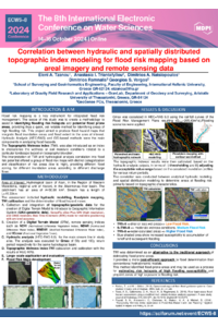
Poster_sciforum103222_ECWS8.pdf
Assessing the Influence of the El Niño--Southern Oscillation (ENSO) and Indian Ocean Dipole (IOD) on Precipitation in Iran Using Kendall and Pearson Correlations
Issues of associated water utilisation management at hydrocarbon fields in the north of the West Siberian oil and gas producing region