Event submissions
Published
This submission belongs to the session S5. Land Use Dynamics and Socio-Ecological Systems: Modeling Across Scales of the event The 2nd International Electronic Conference on Land
Published date
02 Sep, 2025
Academic Editor
'%3e%3cpath%20d='M12.6657%2010.9104C12.4185%2010.325%2012.0599%209.79327%2011.6097%209.34482C11.1609%208.89508%2010.6293%208.5365%2010.0442%208.28888C10.0389%208.28626%2010.0337%208.28495%2010.0285%208.28233C10.8446%207.69279%2011.3752%206.73249%2011.3752%205.64904C11.3752%203.8542%209.92103%202.39999%208.1262%202.39999C6.33136%202.39999%204.87715%203.8542%204.87715%205.64904C4.87715%206.73249%205.40774%207.69279%206.22393%208.28364C6.21869%208.28626%206.21345%208.28757%206.20821%208.29019C5.62129%208.5378%205.09463%208.89284%204.64265%209.34613C4.1929%209.79493%203.83432%2010.3266%203.58671%2010.9117C3.34345%2011.4845%203.21226%2012.0987%203.20023%2012.7209C3.19988%2012.7349%203.20233%2012.7488%203.20744%2012.7619C3.21255%2012.7749%203.22022%2012.7867%203.22998%2012.7968C3.23975%2012.8068%203.25142%2012.8147%203.26431%2012.8202C3.2772%2012.8256%203.29105%2012.8284%203.30504%2012.8284H4.09109C4.14874%2012.8284%204.19459%2012.7825%204.1959%2012.7262C4.2221%2011.7148%204.62823%2010.7676%205.34617%2010.0497C6.08899%209.30683%207.0755%208.89808%208.1262%208.89808C9.17689%208.89808%2010.1634%209.30683%2010.9062%2010.0497C11.6242%2010.7676%2012.0303%2011.7148%2012.0565%2012.7262C12.0578%2012.7838%2012.1037%2012.8284%2012.1613%2012.8284H12.9474C12.9613%2012.8284%2012.9752%2012.8256%2012.9881%2012.8202C13.001%2012.8147%2013.0126%2012.8068%2013.0224%2012.7968C13.0322%2012.7867%2013.0398%2012.7749%2013.0449%2012.7619C13.0501%2012.7488%2013.0525%2012.7349%2013.0522%2012.7209C13.0391%2012.0947%2012.9094%2011.4855%2012.6657%2010.9104ZM8.1262%207.9024C7.52486%207.9024%206.9589%207.6679%206.53312%207.24211C6.10733%206.81633%205.87283%206.25037%205.87283%205.64904C5.87283%205.0477%206.10733%204.48174%206.53312%204.05596C6.9589%203.63018%207.52486%203.39567%208.1262%203.39567C8.72753%203.39567%209.29349%203.63018%209.71927%204.05596C10.1451%204.48174%2010.3796%205.0477%2010.3796%205.64904C10.3796%206.25037%2010.1451%206.81633%209.71927%207.24211C9.29349%207.6679%208.72753%207.9024%208.1262%207.9024Z'%20fill='%235D1EE1'/%3e%3c/g%3e%3c/svg%3e) Hossein Azadi
Hossein AzadiCitation
Carlo SODALO, Kouagou Raoul SAMBIENI, Yves Justin Arcadius AKOSSOU, Jan Bogaert, Classified forests under pressure: geospatial analysis of degradation dynamics in Northern Benin, in Proceedings of The 2nd International Electronic Conference on Land, 4 September–5 September 2025, MDPI: Basel, Switzerland
Share
Email
Facebook
Twitter
LinkedIn
Classified forests under pressure: geospatial analysis of degradation dynamics in Northern Benin
'%3e%3cpath%20d='M12.6647%2010.9104C12.4176%2010.325%2012.0589%209.7933%2011.6088%209.34485C11.16%208.89511%2010.6283%208.53653%2010.0432%208.28891C10.038%208.28629%2010.0327%208.28498%2010.0275%208.28236C10.8437%207.69282%2011.3743%206.73252%2011.3743%205.64907C11.3743%203.85423%209.92005%202.40002%208.12522%202.40002C6.33038%202.40002%204.87618%203.85423%204.87618%205.64907C4.87618%206.73252%205.40677%207.69282%206.22296%208.28367C6.21772%208.28629%206.21248%208.2876%206.20724%208.29022C5.62031%208.53783%205.09365%208.89287%204.64167%209.34616C4.19192%209.79496%203.83334%2010.3266%203.58573%2010.9117C3.34247%2011.4846%203.21128%2012.0987%203.19925%2012.721C3.1989%2012.735%203.20135%2012.7489%203.20646%2012.7619C3.21157%2012.7749%203.21924%2012.7868%203.22901%2012.7968C3.23877%2012.8068%203.25045%2012.8148%203.26334%2012.8202C3.27623%2012.8256%203.29007%2012.8284%203.30406%2012.8284H4.09012C4.14776%2012.8284%204.19362%2012.7825%204.19493%2012.7262C4.22113%2011.7148%204.62726%2010.7676%205.34519%2010.0497C6.08802%209.30686%207.07452%208.89811%208.12522%208.89811C9.17592%208.89811%2010.1624%209.30686%2010.9052%2010.0497C11.6232%2010.7676%2012.0293%2011.7148%2012.0555%2012.7262C12.0568%2012.7839%2012.1027%2012.8284%2012.1603%2012.8284H12.9464C12.9604%2012.8284%2012.9742%2012.8256%2012.9871%2012.8202C13%2012.8148%2013.0117%2012.8068%2013.0214%2012.7968C13.0312%2012.7868%2013.0389%2012.7749%2013.044%2012.7619C13.0491%2012.7489%2013.0515%2012.735%2013.0512%2012.721C13.0381%2012.0947%2012.9084%2011.4856%2012.6647%2010.9104ZM8.12522%207.90243C7.52388%207.90243%206.95792%207.66793%206.53214%207.24215C6.10636%206.81636%205.87185%206.2504%205.87185%205.64907C5.87185%205.04773%206.10636%204.48177%206.53214%204.05599C6.95792%203.63021%207.52388%203.3957%208.12522%203.3957C8.72655%203.3957%209.29252%203.63021%209.7183%204.05599C10.1441%204.48177%2010.3786%205.04773%2010.3786%205.64907C10.3786%206.2504%2010.1441%206.81636%209.7183%207.24215C9.29252%207.66793%208.72655%207.90243%208.12522%207.90243Z'%20fill='%235D1EE1'/%3e%3c/g%3e%3c/svg%3e)
Carlo SODALO 1
Kouagou Raoul SAMBIENI 2
Yves Justin Arcadius AKOSSOU 2
Jan Bogaert 1
1. Biodiversity, Ecosystems and Landscape Unit; Gembloux Agro-Bio Tech, University of Liège; Gembloux; 5030; Belgium
2. Regional Postgraduate Training School on Integrated Management of Tropical Forests and Lands (ERAIFT); Kinshasa; Democratic Republic of Congo (DRC)
Abstract
The forest complex Ouémé Supérieur–Wari Maro–Monts Kouffé in northern Benin constitutes an ecosystem of great ecological wealth but remains confronted with deforestation and accelerated degradation due to increasing anthropogenic pressures. This study aims to analyze the degradation hotspots in this complex through time and across space, highlighting human and infrastructural factors. To this end, an integrated methodological approach was mobilized, based on a diachronic analysis of multitemporal satellite images (from the years 1986 to 2024), coupled with remote sensing tools and geographic information systems (GISs). The results reveal a substantial increase in cultivated fields and fallows, from 454.12 ha (0.09% of the complex) in 1986 to 29,400.5 ha (6%) in 2024. Forest cover declined by 17.21% over the same period. Conversely, savannas expanded from 116,359.54 ha (23.73%) to 172,550.23 ha (35.19%). Land transformation processes, analyzed using Bogaert’s decision tree, show continuous agricultural expansion, with the number of patches rising from 288 in 1986 to 2,742 in 2024. However, the 2024 pattern is marked by spatial aggregation rather than new patch creation, as indicated by the increase in the average patch size from 1.6 ha to 10.7 ha. Notably, a large share of these aggregated areas is located near roads, suggesting that accessibility plays a key role in land conversion. The linear regression between the proportion of fields/fallows and proximity to asphalt roads shows a determination coefficient R2 of 0.72 with a p-value < 0.01, indicating a strong and significant relationship. The fragmentation of the landscape is intensifying, particularly around asphalted roads, as well as unpaved ones. These findings highlight the need for a re-reading of protected forest management strategies, including better supervision of agricultural expansion, regulation of road developments, and increased involvement of local actors in environmental governance mechanisms.
Keywords
Remote sensing
roads
anthropogenic pressure
Ouémé Supérieur - Wari Maro - Monts Kouffé
landscape ecology
Poster
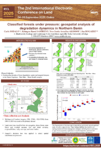
IECL 2025 Poster SODALO.pdf
Assessing the Impact of Illegal Gold Mining on the Fluvial Morphology of the Punino River in the Ecuadorian Amazon
Geospatial Tools and Mining Laws: Analysis of Regulatory Efficiency in the Ecuadorian Amazon