Event submissions
Published
This submission belongs to the session S2. Landscape Architecture and Land Restoration of the event The 2nd International Electronic Conference on Land
Published date
02 Sep, 2025
Academic Editor
'%3e%3cpath%20d='M12.6657%2010.9104C12.4185%2010.325%2012.0599%209.79327%2011.6097%209.34482C11.1609%208.89508%2010.6293%208.5365%2010.0442%208.28888C10.0389%208.28626%2010.0337%208.28495%2010.0285%208.28233C10.8446%207.69279%2011.3752%206.73249%2011.3752%205.64904C11.3752%203.8542%209.92103%202.39999%208.1262%202.39999C6.33136%202.39999%204.87715%203.8542%204.87715%205.64904C4.87715%206.73249%205.40774%207.69279%206.22393%208.28364C6.21869%208.28626%206.21345%208.28757%206.20821%208.29019C5.62129%208.5378%205.09463%208.89284%204.64265%209.34613C4.1929%209.79493%203.83432%2010.3266%203.58671%2010.9117C3.34345%2011.4845%203.21226%2012.0987%203.20023%2012.7209C3.19988%2012.7349%203.20233%2012.7488%203.20744%2012.7619C3.21255%2012.7749%203.22022%2012.7867%203.22998%2012.7968C3.23975%2012.8068%203.25142%2012.8147%203.26431%2012.8202C3.2772%2012.8256%203.29105%2012.8284%203.30504%2012.8284H4.09109C4.14874%2012.8284%204.19459%2012.7825%204.1959%2012.7262C4.2221%2011.7148%204.62823%2010.7676%205.34617%2010.0497C6.08899%209.30683%207.0755%208.89808%208.1262%208.89808C9.17689%208.89808%2010.1634%209.30683%2010.9062%2010.0497C11.6242%2010.7676%2012.0303%2011.7148%2012.0565%2012.7262C12.0578%2012.7838%2012.1037%2012.8284%2012.1613%2012.8284H12.9474C12.9613%2012.8284%2012.9752%2012.8256%2012.9881%2012.8202C13.001%2012.8147%2013.0126%2012.8068%2013.0224%2012.7968C13.0322%2012.7867%2013.0398%2012.7749%2013.0449%2012.7619C13.0501%2012.7488%2013.0525%2012.7349%2013.0522%2012.7209C13.0391%2012.0947%2012.9094%2011.4855%2012.6657%2010.9104ZM8.1262%207.9024C7.52486%207.9024%206.9589%207.6679%206.53312%207.24211C6.10733%206.81633%205.87283%206.25037%205.87283%205.64904C5.87283%205.0477%206.10733%204.48174%206.53312%204.05596C6.9589%203.63018%207.52486%203.39567%208.1262%203.39567C8.72753%203.39567%209.29349%203.63018%209.71927%204.05596C10.1451%204.48174%2010.3796%205.0477%2010.3796%205.64904C10.3796%206.25037%2010.1451%206.81633%209.71927%207.24211C9.29349%207.6679%208.72753%207.9024%208.1262%207.9024Z'%20fill='%235D1EE1'/%3e%3c/g%3e%3c/svg%3e) Thomas Panagopoulos
Thomas PanagopoulosCitation
Rafael Becerra-Ramírez, Darío Guevara, Estela Escobar, Margarita Moreno, Rafael Ubaldo Gosálvez, Elena González, Javier Dóniz-Páez, Arianna Testa, The Cañadas Reales of the UNESCO Global Geopark Volcanes de Calatrava, Ciudad Real (Spain): a backbone of geomorphological heritage and Geotourism, in Proceedings of The 2nd International Electronic Conference on Land, 4 September–5 September 2025, MDPI: Basel, Switzerland
Share
Email
Facebook
Twitter
LinkedIn
The Cañadas Reales of the UNESCO Global Geopark Volcanes de Calatrava, Ciudad Real (Spain): a backbone of geomorphological heritage and Geotourism

Rafael Becerra-Ramírez 1,2

Darío Guevara 1
'%3e%3cpath%20d='M12.6647%2010.9104C12.4176%2010.325%2012.0589%209.7933%2011.6088%209.34485C11.16%208.89511%2010.6283%208.53653%2010.0432%208.28891C10.038%208.28629%2010.0327%208.28498%2010.0275%208.28236C10.8437%207.69282%2011.3743%206.73252%2011.3743%205.64907C11.3743%203.85423%209.92005%202.40002%208.12522%202.40002C6.33038%202.40002%204.87618%203.85423%204.87618%205.64907C4.87618%206.73252%205.40677%207.69282%206.22296%208.28367C6.21772%208.28629%206.21248%208.2876%206.20724%208.29022C5.62031%208.53783%205.09365%208.89287%204.64167%209.34616C4.19192%209.79496%203.83334%2010.3266%203.58573%2010.9117C3.34247%2011.4846%203.21128%2012.0987%203.19925%2012.721C3.1989%2012.735%203.20135%2012.7489%203.20646%2012.7619C3.21157%2012.7749%203.21924%2012.7868%203.22901%2012.7968C3.23877%2012.8068%203.25045%2012.8148%203.26334%2012.8202C3.27623%2012.8256%203.29007%2012.8284%203.30406%2012.8284H4.09012C4.14776%2012.8284%204.19362%2012.7825%204.19493%2012.7262C4.22113%2011.7148%204.62726%2010.7676%205.34519%2010.0497C6.08802%209.30686%207.07452%208.89811%208.12522%208.89811C9.17592%208.89811%2010.1624%209.30686%2010.9052%2010.0497C11.6232%2010.7676%2012.0293%2011.7148%2012.0555%2012.7262C12.0568%2012.7839%2012.1027%2012.8284%2012.1603%2012.8284H12.9464C12.9604%2012.8284%2012.9742%2012.8256%2012.9871%2012.8202C13%2012.8148%2013.0117%2012.8068%2013.0214%2012.7968C13.0312%2012.7868%2013.0389%2012.7749%2013.044%2012.7619C13.0491%2012.7489%2013.0515%2012.735%2013.0512%2012.721C13.0381%2012.0947%2012.9084%2011.4856%2012.6647%2010.9104ZM8.12522%207.90243C7.52388%207.90243%206.95792%207.66793%206.53214%207.24215C6.10636%206.81636%205.87185%206.2504%205.87185%205.64907C5.87185%205.04773%206.10636%204.48177%206.53214%204.05599C6.95792%203.63021%207.52388%203.3957%208.12522%203.3957C8.72655%203.3957%209.29252%203.63021%209.7183%204.05599C10.1441%204.48177%2010.3786%205.04773%2010.3786%205.64907C10.3786%206.2504%2010.1441%206.81636%209.7183%207.24215C9.29252%207.66793%208.72655%207.90243%208.12522%207.90243Z'%20fill='%235D1EE1'/%3e%3c/g%3e%3c/svg%3e)
Estela Escobar 1,2
Margarita Moreno 1,3

Rafael Ubaldo Gosálvez 1,2
Elena González 1,2

Javier Dóniz-Páez 2,4
Arianna Testa 5
1. GEOVOL-UCLM, Department of Geography and Land Management; University of Castilla-La Mancha; Ciudad Real; 13071; Spain
2. Volcanological Institute of the Canary Islands (INVOLCAN); San Cristóbal de La Laguna; 38200; Spain
3. CEPA Antonio Machado; Ministry of Education, Culture and Sports of Castilla-La Mancha; Ciudad Real; 13071; Spain
4. GEOTURVOL, Department of Geography and History; University of La Laguna; San Cristóbal de La Laguna; 38200; Spain
5. Department of History, Cultural Heritage, Education and Society; University of Rome "Tor Vergata"; Rome; 00133; Italy
Abstract
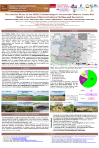
The Cañadas Reales (‘Royal Cattle Paths’) have been a transit route for transhumant cattle on their annual winter pilgrimage from northern Spain to central and southern Spain from their creation in the 13th century to the present day. Their origin dates to the Roman roads and tracks in Hispania. Transhumance was included in the list of UNESCO Intangible Cultural World Heritage in 2023. The Cañadas have been of great importance in the history of the territory of the UNESCO Global Geopark Volcanes de Calatrava, Ciudad Real (Spain). Within it, the areas of Campo de Calatrava and Alcudia Valley are the places where cattle from the northhibernate. Three cañadas—the Toledana, Segoviana and Soriana Oriental—converge and form the backbone of the geopark, together with other secondary cattle paths (cordeles, veredas and coladas).
The geopark shows a high level of geodiversity and geoheritage on an area of 4,383 km2 belonging to 40 municipalities, linked to two Spanish Geological Contexts of International Relevance (Law 33/2015): the Mercury Mineralizations and the Neogene–Quaternary Volcanism of the Iberian Peninsula.
This work presents an inventory of the geomorphological heritage of volcanic and natural protected areas at the regional and European level (Natura 2000 network), as well as other resources of historical–cultural and ethnographic heritage, linked to the Cañadas Reales (sour water fountains, hot springs, baths, transhumance architecture, abandoned mines...). The objective is to promote geotourism through sites of geotouristic interest (natural and cultural) and through actions to be carried out by the Geopark's management body.
The proposed actions focus on refurbishing the official hiking routes within the Cañadas (georoutes or geoitineraries), providing them with informative content; creating interpretation centers for the Geopark ('Volcano House') and relative to transhumance, taking advantage of historic or disused buildings (such as the airport visitor center); resuming training courses for Geopark guide staff; and taking advantage of the synergies of the transport network (highways, high-speed trains, airport).
Keywords
Calatrava Volcanoes
Geomorphological heritage
Geotourism
Unesco Global Geopark
Transhumance
Poster
Becerraetal-2025_CanadasReales_Geopark.pdf
Assessing Industrial Land's Suitability for Sustainable Urban Planning in Dhaka Region Using Geospatial Techniques
Sustainable and Inclusive Cities? Strategic Urban Regeneration of Decommissioned Industrial Sites in France