Event submissions
Published
This submission belongs to the session S1. Urbanization and Land Use: Navigating the Future of Cities of the event The 2nd International Electronic Conference on Land
Published date
02 Sep, 2025
Academic Editor
'%3e%3cpath%20d='M12.6657%2010.9104C12.4185%2010.325%2012.0599%209.79327%2011.6097%209.34482C11.1609%208.89508%2010.6293%208.5365%2010.0442%208.28888C10.0389%208.28626%2010.0337%208.28495%2010.0285%208.28233C10.8446%207.69279%2011.3752%206.73249%2011.3752%205.64904C11.3752%203.8542%209.92103%202.39999%208.1262%202.39999C6.33136%202.39999%204.87715%203.8542%204.87715%205.64904C4.87715%206.73249%205.40774%207.69279%206.22393%208.28364C6.21869%208.28626%206.21345%208.28757%206.20821%208.29019C5.62129%208.5378%205.09463%208.89284%204.64265%209.34613C4.1929%209.79493%203.83432%2010.3266%203.58671%2010.9117C3.34345%2011.4845%203.21226%2012.0987%203.20023%2012.7209C3.19988%2012.7349%203.20233%2012.7488%203.20744%2012.7619C3.21255%2012.7749%203.22022%2012.7867%203.22998%2012.7968C3.23975%2012.8068%203.25142%2012.8147%203.26431%2012.8202C3.2772%2012.8256%203.29105%2012.8284%203.30504%2012.8284H4.09109C4.14874%2012.8284%204.19459%2012.7825%204.1959%2012.7262C4.2221%2011.7148%204.62823%2010.7676%205.34617%2010.0497C6.08899%209.30683%207.0755%208.89808%208.1262%208.89808C9.17689%208.89808%2010.1634%209.30683%2010.9062%2010.0497C11.6242%2010.7676%2012.0303%2011.7148%2012.0565%2012.7262C12.0578%2012.7838%2012.1037%2012.8284%2012.1613%2012.8284H12.9474C12.9613%2012.8284%2012.9752%2012.8256%2012.9881%2012.8202C13.001%2012.8147%2013.0126%2012.8068%2013.0224%2012.7968C13.0322%2012.7867%2013.0398%2012.7749%2013.0449%2012.7619C13.0501%2012.7488%2013.0525%2012.7349%2013.0522%2012.7209C13.0391%2012.0947%2012.9094%2011.4855%2012.6657%2010.9104ZM8.1262%207.9024C7.52486%207.9024%206.9589%207.6679%206.53312%207.24211C6.10733%206.81633%205.87283%206.25037%205.87283%205.64904C5.87283%205.0477%206.10733%204.48174%206.53312%204.05596C6.9589%203.63018%207.52486%203.39567%208.1262%203.39567C8.72753%203.39567%209.29349%203.63018%209.71927%204.05596C10.1451%204.48174%2010.3796%205.0477%2010.3796%205.64904C10.3796%206.25037%2010.1451%206.81633%209.71927%207.24211C9.29349%207.6679%208.72753%207.9024%208.1262%207.9024Z'%20fill='%235D1EE1'/%3e%3c/g%3e%3c/svg%3e) Chuanrong Zhang
Chuanrong ZhangCitation
PURBA BISWAS, PRIYANKA DEY, Spatiotemporal Analysis of Land Use Dynamics and Built-up transformation of Industrial Cities along Delhi–Mumbai Corridor: Case of Ahmedabad and Surat, in Proceedings of The 2nd International Electronic Conference on Land, 4 September–5 September 2025, MDPI: Basel, Switzerland
Share
Email
Facebook
Twitter
LinkedIn
Spatiotemporal Analysis of Land Use Dynamics and Built-up transformation of Industrial Cities along Delhi–Mumbai Corridor: Case of Ahmedabad and Surat
'%3e%3cpath%20d='M12.6647%2010.9104C12.4176%2010.325%2012.0589%209.7933%2011.6088%209.34485C11.16%208.89511%2010.6283%208.53653%2010.0432%208.28891C10.038%208.28629%2010.0327%208.28498%2010.0275%208.28236C10.8437%207.69282%2011.3743%206.73252%2011.3743%205.64907C11.3743%203.85423%209.92005%202.40002%208.12522%202.40002C6.33038%202.40002%204.87618%203.85423%204.87618%205.64907C4.87618%206.73252%205.40677%207.69282%206.22296%208.28367C6.21772%208.28629%206.21248%208.2876%206.20724%208.29022C5.62031%208.53783%205.09365%208.89287%204.64167%209.34616C4.19192%209.79496%203.83334%2010.3266%203.58573%2010.9117C3.34247%2011.4846%203.21128%2012.0987%203.19925%2012.721C3.1989%2012.735%203.20135%2012.7489%203.20646%2012.7619C3.21157%2012.7749%203.21924%2012.7868%203.22901%2012.7968C3.23877%2012.8068%203.25045%2012.8148%203.26334%2012.8202C3.27623%2012.8256%203.29007%2012.8284%203.30406%2012.8284H4.09012C4.14776%2012.8284%204.19362%2012.7825%204.19493%2012.7262C4.22113%2011.7148%204.62726%2010.7676%205.34519%2010.0497C6.08802%209.30686%207.07452%208.89811%208.12522%208.89811C9.17592%208.89811%2010.1624%209.30686%2010.9052%2010.0497C11.6232%2010.7676%2012.0293%2011.7148%2012.0555%2012.7262C12.0568%2012.7839%2012.1027%2012.8284%2012.1603%2012.8284H12.9464C12.9604%2012.8284%2012.9742%2012.8256%2012.9871%2012.8202C13%2012.8148%2013.0117%2012.8068%2013.0214%2012.7968C13.0312%2012.7868%2013.0389%2012.7749%2013.044%2012.7619C13.0491%2012.7489%2013.0515%2012.735%2013.0512%2012.721C13.0381%2012.0947%2012.9084%2011.4856%2012.6647%2010.9104ZM8.12522%207.90243C7.52388%207.90243%206.95792%207.66793%206.53214%207.24215C6.10636%206.81636%205.87185%206.2504%205.87185%205.64907C5.87185%205.04773%206.10636%204.48177%206.53214%204.05599C6.95792%203.63021%207.52388%203.3957%208.12522%203.3957C8.72655%203.3957%209.29252%203.63021%209.7183%204.05599C10.1441%204.48177%2010.3786%205.04773%2010.3786%205.64907C10.3786%206.2504%2010.1441%206.81636%209.7183%207.24215C9.29252%207.66793%208.72655%207.90243%208.12522%207.90243Z'%20fill='%235D1EE1'/%3e%3c/g%3e%3c/svg%3e)
PURBA BISWAS 1
PRIYANKA DEY 1
1. Indian Institute of Technology Kharagpur (IIT Kharagpur); Kharagpur; 721302; India
Abstract
The 21st century is witnessing an unprecedented pace of urbanisation due to industrialisation, reshaping landscapes, and redefining the land utilisation process across the world. This transformation presents both opportunities and critical challenges, particularly in rapidly developing nations where urban expansion is often unplanned and ecologically disruptive. The interface between urban growth and land use dynamics has become a focal point for policymakers, planners, and researchers seeking to ensure a sustainable and resilient urban future. Urbanisation in India’s industrial corridors has led to significant land use transformations, particularly in rapidly growing industrial cities such as Ahmedabad and Surat—two strategic urban centres along the Delhi–Mumbai Industrial Corridor (DMIC). This study presents a comparative spatiotemporal analysis of built-up expansion and land use/land cover (LULC) dynamics in both cities over the past two decades (2000–2020), aiming to evaluate the spatial implications of industrial growth on urban form and land conversion patterns. Using multi-temporal Landsat satellite imageries, the Normalised Difference Built-Up Index (NDBI) and supervised LULC classifications in a GIS, LULC transformations and built-up changes were spatially analysed within the city boundary. The findings reveal a contrasting yet converging pattern of urban expansion—while Ahmedabad exhibits a more radial and zonally structured growth due to its planned industrial development, Surat demonstrates a dispersed expansion with significant encroachment into agricultural and barren lands. The built-up area in Ahmedabad and Surat is increased by 13.24% and 26.60%, respectively, from 2000 to 2020. Industrial growth and corridor development are significantly contributing to the increase in urban footprints, especially in the areas influenced by economic zones. This study highlights industrialisation as a critical driver of land use transformation, exacerbating peri-urban sprawl and ecological fragmentation, and the need for more planned and sustainable urban growth—merging remote sensing and urban morphology—to provide spatially explicit evidence of the present situation and future sustainable planning.
Keywords
Urbanisation
LULC Dynamics
Built-up Expansion
Industrial Corridor
GIS
Remote Sensing
Poster
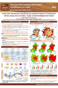
Poster_Purba Biswas.pdf
Sustainable and Inclusive Cities? Strategic Urban Regeneration of Decommissioned Industrial Sites in France
Total belowground carbon flux response of Eucalyptus genotypes to water deficit in Mediterranean Chile