Event submissions
Published
This submission belongs to the session S6. Smart Farming: From Sensor to Artificial Intelligence of the event The 3rd International Online Conference on Agriculture
Published date
20 Oct, 2025
Academic Editor
'%3e%3cpath%20d='M12.6657%2010.9104C12.4185%2010.325%2012.0599%209.79327%2011.6097%209.34482C11.1609%208.89508%2010.6293%208.5365%2010.0442%208.28888C10.0389%208.28626%2010.0337%208.28495%2010.0285%208.28233C10.8446%207.69279%2011.3752%206.73249%2011.3752%205.64904C11.3752%203.8542%209.92103%202.39999%208.1262%202.39999C6.33136%202.39999%204.87715%203.8542%204.87715%205.64904C4.87715%206.73249%205.40774%207.69279%206.22393%208.28364C6.21869%208.28626%206.21345%208.28757%206.20821%208.29019C5.62129%208.5378%205.09463%208.89284%204.64265%209.34613C4.1929%209.79493%203.83432%2010.3266%203.58671%2010.9117C3.34345%2011.4845%203.21226%2012.0987%203.20023%2012.7209C3.19988%2012.7349%203.20233%2012.7488%203.20744%2012.7619C3.21255%2012.7749%203.22022%2012.7867%203.22998%2012.7968C3.23975%2012.8068%203.25142%2012.8147%203.26431%2012.8202C3.2772%2012.8256%203.29105%2012.8284%203.30504%2012.8284H4.09109C4.14874%2012.8284%204.19459%2012.7825%204.1959%2012.7262C4.2221%2011.7148%204.62823%2010.7676%205.34617%2010.0497C6.08899%209.30683%207.0755%208.89808%208.1262%208.89808C9.17689%208.89808%2010.1634%209.30683%2010.9062%2010.0497C11.6242%2010.7676%2012.0303%2011.7148%2012.0565%2012.7262C12.0578%2012.7838%2012.1037%2012.8284%2012.1613%2012.8284H12.9474C12.9613%2012.8284%2012.9752%2012.8256%2012.9881%2012.8202C13.001%2012.8147%2013.0126%2012.8068%2013.0224%2012.7968C13.0322%2012.7867%2013.0398%2012.7749%2013.0449%2012.7619C13.0501%2012.7488%2013.0525%2012.7349%2013.0522%2012.7209C13.0391%2012.0947%2012.9094%2011.4855%2012.6657%2010.9104ZM8.1262%207.9024C7.52486%207.9024%206.9589%207.6679%206.53312%207.24211C6.10733%206.81633%205.87283%206.25037%205.87283%205.64904C5.87283%205.0477%206.10733%204.48174%206.53312%204.05596C6.9589%203.63018%207.52486%203.39567%208.1262%203.39567C8.72753%203.39567%209.29349%203.63018%209.71927%204.05596C10.1451%204.48174%2010.3796%205.0477%2010.3796%205.64904C10.3796%206.25037%2010.1451%206.81633%209.71927%207.24211C9.29349%207.6679%208.72753%207.9024%208.1262%207.9024Z'%20fill='%235D1EE1'/%3e%3c/g%3e%3c/svg%3e) Sanzidur Rahman
Sanzidur RahmanCitation
Tarun Teja Kondraju, Rabi N. Sahoo, R. G. Rejith, Amrita Bhandari, Rajeev Ranjan, Devanakonda Venkata Sai Chakradhar Reddy, Selvaprakash Ramalingam, Retrieving Canopy Chlorophyll Content from Sentinel-2 imagery using Google Earth Engine, in Proceedings of The 3rd International Online Conference on Agriculture, 22 October–24 October 2025, MDPI: Basel, Switzerland
Share
Email
Facebook
Twitter
LinkedIn
Retrieving Canopy Chlorophyll Content from Sentinel-2 imagery using Google Earth Engine
'%3e%3cpath%20d='M12.6647%2010.9104C12.4176%2010.325%2012.0589%209.7933%2011.6088%209.34485C11.16%208.89511%2010.6283%208.53653%2010.0432%208.28891C10.038%208.28629%2010.0327%208.28498%2010.0275%208.28236C10.8437%207.69282%2011.3743%206.73252%2011.3743%205.64907C11.3743%203.85423%209.92005%202.40002%208.12522%202.40002C6.33038%202.40002%204.87618%203.85423%204.87618%205.64907C4.87618%206.73252%205.40677%207.69282%206.22296%208.28367C6.21772%208.28629%206.21248%208.2876%206.20724%208.29022C5.62031%208.53783%205.09365%208.89287%204.64167%209.34616C4.19192%209.79496%203.83334%2010.3266%203.58573%2010.9117C3.34247%2011.4846%203.21128%2012.0987%203.19925%2012.721C3.1989%2012.735%203.20135%2012.7489%203.20646%2012.7619C3.21157%2012.7749%203.21924%2012.7868%203.22901%2012.7968C3.23877%2012.8068%203.25045%2012.8148%203.26334%2012.8202C3.27623%2012.8256%203.29007%2012.8284%203.30406%2012.8284H4.09012C4.14776%2012.8284%204.19362%2012.7825%204.19493%2012.7262C4.22113%2011.7148%204.62726%2010.7676%205.34519%2010.0497C6.08802%209.30686%207.07452%208.89811%208.12522%208.89811C9.17592%208.89811%2010.1624%209.30686%2010.9052%2010.0497C11.6232%2010.7676%2012.0293%2011.7148%2012.0555%2012.7262C12.0568%2012.7839%2012.1027%2012.8284%2012.1603%2012.8284H12.9464C12.9604%2012.8284%2012.9742%2012.8256%2012.9871%2012.8202C13%2012.8148%2013.0117%2012.8068%2013.0214%2012.7968C13.0312%2012.7868%2013.0389%2012.7749%2013.044%2012.7619C13.0491%2012.7489%2013.0515%2012.735%2013.0512%2012.721C13.0381%2012.0947%2012.9084%2011.4856%2012.6647%2010.9104ZM8.12522%207.90243C7.52388%207.90243%206.95792%207.66793%206.53214%207.24215C6.10636%206.81636%205.87185%206.2504%205.87185%205.64907C5.87185%205.04773%206.10636%204.48177%206.53214%204.05599C6.95792%203.63021%207.52388%203.3957%208.12522%203.3957C8.72655%203.3957%209.29252%203.63021%209.7183%204.05599C10.1441%204.48177%2010.3786%205.04773%2010.3786%205.64907C10.3786%206.2504%2010.1441%206.81636%209.7183%207.24215C9.29252%207.66793%208.72655%207.90243%208.12522%207.90243Z'%20fill='%235D1EE1'/%3e%3c/g%3e%3c/svg%3e)
Tarun Teja Kondraju 1
Rabi N. Sahoo 1
R. G. Rejith 1
Amrita Bhandari 1
Rajeev Ranjan 1

Devanakonda Venkata Sai Chakradhar Reddy 1
Selvaprakash Ramalingam 1
1. Indian Council of Agricultural Research (ICAR) - Indian Agricultural Research Institute, New Delhi, 110012, India
Abstract
Google Earth Engine (GEE) has revolutionized remote sensing. The GEE cloud platform lets users quickly analyze large satellite imagery datasets with custom programs, enhancing global-scale analysis. Crop condition monitoring using GEE would greatly help in decision-making and precision agriculture. Estimating canopy chlorophyll content (CCC) is an effective method for monitoring crops through remote sensing because chlorophyll in leaves is a key indicator. A hybrid model that combines radiative transfer models (RTMs), such as PROSAIL, with Gaussian Process Regression (GPR) can effectively estimate crop biophysical parameters using remote sensing images. GPR has proven to be one of the best methods for this purpose. This study aimed to develop a hybrid model to estimate CCC from S2 imagery and transfer it to the GEE platform for efficient data processing. In this work, the CCC (g/cm2) data from the S2 biophysical processor toolbox for the S2 imagery of ICAR-Indian Agricultural Research Institute (IARI) on February 23rd, 2023, was used as observation data to train the hybrid algorithm. The hybrid model was successfully validated against the 155 input data with an R2 of 0.94, RMSE of 10.02, and NRMSE of 5.04%. The model was integrated into GEE to successfully create a CCC estimated map of IARI using S2 imagery from February 23, 2023. An R2 value of 0.96 was observed when GEE-estimated CCC values were compared against CCC values estimated locally. This establishes that the GEE-based CCC estimation with the PROSAIL+GPR hybrid model is an effective and accurate method for monitoring vegetation and crop conditions over large areas and extended periods.
Keywords
Keywords: Google Earth Engine
Sentinel 2
Canopy Chlorophyll Content
PROSAIL
GPR
Poster
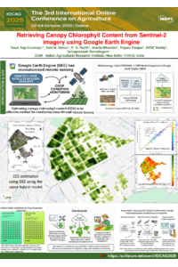
IOCAG_poster.pdf
Future Prospects of Fruit and vegetable crop Breeding in the Middle East
ADDRESSING SEAWATER INTRUSION AT DIFFERENT GROWTH STAGES OF RICE (Oryza sativa L.) USING SELECTED SALINE-TOLERANT VARIETIES