Event submissions
Published
This submission belongs to the session S7. Agricultural Soil of the event The 3rd International Online Conference on Agriculture
Published date
20 Oct, 2025
Academic Editor
'%3e%3cpath%20d='M12.6657%2010.9104C12.4185%2010.325%2012.0599%209.79327%2011.6097%209.34482C11.1609%208.89508%2010.6293%208.5365%2010.0442%208.28888C10.0389%208.28626%2010.0337%208.28495%2010.0285%208.28233C10.8446%207.69279%2011.3752%206.73249%2011.3752%205.64904C11.3752%203.8542%209.92103%202.39999%208.1262%202.39999C6.33136%202.39999%204.87715%203.8542%204.87715%205.64904C4.87715%206.73249%205.40774%207.69279%206.22393%208.28364C6.21869%208.28626%206.21345%208.28757%206.20821%208.29019C5.62129%208.5378%205.09463%208.89284%204.64265%209.34613C4.1929%209.79493%203.83432%2010.3266%203.58671%2010.9117C3.34345%2011.4845%203.21226%2012.0987%203.20023%2012.7209C3.19988%2012.7349%203.20233%2012.7488%203.20744%2012.7619C3.21255%2012.7749%203.22022%2012.7867%203.22998%2012.7968C3.23975%2012.8068%203.25142%2012.8147%203.26431%2012.8202C3.2772%2012.8256%203.29105%2012.8284%203.30504%2012.8284H4.09109C4.14874%2012.8284%204.19459%2012.7825%204.1959%2012.7262C4.2221%2011.7148%204.62823%2010.7676%205.34617%2010.0497C6.08899%209.30683%207.0755%208.89808%208.1262%208.89808C9.17689%208.89808%2010.1634%209.30683%2010.9062%2010.0497C11.6242%2010.7676%2012.0303%2011.7148%2012.0565%2012.7262C12.0578%2012.7838%2012.1037%2012.8284%2012.1613%2012.8284H12.9474C12.9613%2012.8284%2012.9752%2012.8256%2012.9881%2012.8202C13.001%2012.8147%2013.0126%2012.8068%2013.0224%2012.7968C13.0322%2012.7867%2013.0398%2012.7749%2013.0449%2012.7619C13.0501%2012.7488%2013.0525%2012.7349%2013.0522%2012.7209C13.0391%2012.0947%2012.9094%2011.4855%2012.6657%2010.9104ZM8.1262%207.9024C7.52486%207.9024%206.9589%207.6679%206.53312%207.24211C6.10733%206.81633%205.87283%206.25037%205.87283%205.64904C5.87283%205.0477%206.10733%204.48174%206.53312%204.05596C6.9589%203.63018%207.52486%203.39567%208.1262%203.39567C8.72753%203.39567%209.29349%203.63018%209.71927%204.05596C10.1451%204.48174%2010.3796%205.0477%2010.3796%205.64904C10.3796%206.25037%2010.1451%206.81633%209.71927%207.24211C9.29349%207.6679%208.72753%207.9024%208.1262%207.9024Z'%20fill='%235D1EE1'/%3e%3c/g%3e%3c/svg%3e) MARGA ROS
MARGA ROSCitation
Nelson Nwobi, Landscape-Based Mitigation of Agrochemical Runoff in Erodible Agricultural Catchments: A Terrain and Soil-Driven Approach from the Idemili Watershed, Southeastern Nigeria, in Proceedings of The 3rd International Online Conference on Agriculture, 22 October–24 October 2025, MDPI: Basel, Switzerland
Share
Email
Facebook
Twitter
LinkedIn
Landscape-Based Mitigation of Agrochemical Runoff in Erodible Agricultural Catchments: A Terrain and Soil-Driven Approach from the Idemili Watershed, Southeastern Nigeria
'%3e%3cpath%20d='M12.6647%2010.9104C12.4176%2010.325%2012.0589%209.7933%2011.6088%209.34485C11.16%208.89511%2010.6283%208.53653%2010.0432%208.28891C10.038%208.28629%2010.0327%208.28498%2010.0275%208.28236C10.8437%207.69282%2011.3743%206.73252%2011.3743%205.64907C11.3743%203.85423%209.92005%202.40002%208.12522%202.40002C6.33038%202.40002%204.87618%203.85423%204.87618%205.64907C4.87618%206.73252%205.40677%207.69282%206.22296%208.28367C6.21772%208.28629%206.21248%208.2876%206.20724%208.29022C5.62031%208.53783%205.09365%208.89287%204.64167%209.34616C4.19192%209.79496%203.83334%2010.3266%203.58573%2010.9117C3.34247%2011.4846%203.21128%2012.0987%203.19925%2012.721C3.1989%2012.735%203.20135%2012.7489%203.20646%2012.7619C3.21157%2012.7749%203.21924%2012.7868%203.22901%2012.7968C3.23877%2012.8068%203.25045%2012.8148%203.26334%2012.8202C3.27623%2012.8256%203.29007%2012.8284%203.30406%2012.8284H4.09012C4.14776%2012.8284%204.19362%2012.7825%204.19493%2012.7262C4.22113%2011.7148%204.62726%2010.7676%205.34519%2010.0497C6.08802%209.30686%207.07452%208.89811%208.12522%208.89811C9.17592%208.89811%2010.1624%209.30686%2010.9052%2010.0497C11.6232%2010.7676%2012.0293%2011.7148%2012.0555%2012.7262C12.0568%2012.7839%2012.1027%2012.8284%2012.1603%2012.8284H12.9464C12.9604%2012.8284%2012.9742%2012.8256%2012.9871%2012.8202C13%2012.8148%2013.0117%2012.8068%2013.0214%2012.7968C13.0312%2012.7868%2013.0389%2012.7749%2013.044%2012.7619C13.0491%2012.7489%2013.0515%2012.735%2013.0512%2012.721C13.0381%2012.0947%2012.9084%2011.4856%2012.6647%2010.9104ZM8.12522%207.90243C7.52388%207.90243%206.95792%207.66793%206.53214%207.24215C6.10636%206.81636%205.87185%206.2504%205.87185%205.64907C5.87185%205.04773%206.10636%204.48177%206.53214%204.05599C6.95792%203.63021%207.52388%203.3957%208.12522%203.3957C8.72655%203.3957%209.29252%203.63021%209.7183%204.05599C10.1441%204.48177%2010.3786%205.04773%2010.3786%205.64907C10.3786%206.2504%2010.1441%206.81636%209.7183%207.24215C9.29252%207.66793%208.72655%207.90243%208.12522%207.90243Z'%20fill='%235D1EE1'/%3e%3c/g%3e%3c/svg%3e)
Nelson Nwobi 1
1. Department of Environmental Safety and Product Quality Management, Faculty of Environmental Engineering, Peoples’ Friendship University of Russia (RUDN University), Moscow 117198, Russia
Abstract
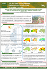
Introduction: Characterised by steep slopes and a humid tropical climate with intense seasonal rains, the Idemili Watershed is prone to soil erosion and agrochemical runoff. Land use and cover change, driven by agricultural practices and urbanisation, exacerbate these processes. This study seeks to evaluate landscape-induced agrochemical runoff potential and determine hotspot erosion zones within the watershed.
Methods: Geospatial and environmental modelling approaches were applied. A 10m Copernicus DEM, SoilGrids v2.0 (sand, silt, clay (SOC)) datasets, and Sentinel-2 images were downloaded. Field surveys and Google Earth were used to validate gully erosion points. The datasets were clipped to the extent of the watershed and projected to WGS 1984 UTM Zone 32N. Slope, Stream, and Power Index (SPI) and Topographic Wetness Index (TWI) were derived in ArcGIS Pro 3.4. The K-factor was estimated using soil texture. Google Earth Engine (GEE) was used to generate LULC classes, namely farmland, built-up, and other. Critical Runoff Source Areas (CRSAs) were determined using slope, SPI, and TWI. The final erosional risk map was produced through weighted overlay (CRSA: 40%, K-factor: 40%, LULC: 20%). The map was validated by overlaying existing gully erosion points.
Results: Elevation varied from 2 to 262m, with high SPI and erosion potential associated with the central steep slopes (up to 55.4°). TWI values highlighted areas of potential moisture accumulation. The silt and clay soils of the northeast and central areas displayed moderate-to-high erodibility over 78% of the watershed. Farmland and built-up land use covered more than 30% of the land area. Areas of high erosion risk (36.5%) and moderate vulnerability (41.6%) overlap with steep, farmed, erodible terrain.
Conclusion: The integrated geospatial approach enabled the identification of erosion hotspots and priority areas for agrochemical runoff. The results have practical implications for targeted and evidence-based interventions to address runoff problems and promote sustainable land use.
Keywords
Soil Erosion
Agrochemical Runoff
Idemili Watershed
Geospatial Analysis
Erosion Risk Assessment
Poster
Sciforum-138122.pdf
Rhizosphere Soil Properties of Peanut (Arachis hypogaea L.) Growing Under Field Conditions in Southern Algeria.
Population of Fungi and Bacteria in Alfisols is Dependent on Seasonal Changes, Poultry Manure Application and Cowpea Varieties