Event submissions
Published
This submission belongs to the session S3. River, Lake and Groundwater Hydraulics, Quality and Vulnerability of the event The 9th International Electronic Conference on Water Sciences
Published date
06 Nov, 2025
Academic Editor
'%3e%3cpath%20d='M12.6657%2010.9104C12.4185%2010.325%2012.0599%209.79327%2011.6097%209.34482C11.1609%208.89508%2010.6293%208.5365%2010.0442%208.28888C10.0389%208.28626%2010.0337%208.28495%2010.0285%208.28233C10.8446%207.69279%2011.3752%206.73249%2011.3752%205.64904C11.3752%203.8542%209.92103%202.39999%208.1262%202.39999C6.33136%202.39999%204.87715%203.8542%204.87715%205.64904C4.87715%206.73249%205.40774%207.69279%206.22393%208.28364C6.21869%208.28626%206.21345%208.28757%206.20821%208.29019C5.62129%208.5378%205.09463%208.89284%204.64265%209.34613C4.1929%209.79493%203.83432%2010.3266%203.58671%2010.9117C3.34345%2011.4845%203.21226%2012.0987%203.20023%2012.7209C3.19988%2012.7349%203.20233%2012.7488%203.20744%2012.7619C3.21255%2012.7749%203.22022%2012.7867%203.22998%2012.7968C3.23975%2012.8068%203.25142%2012.8147%203.26431%2012.8202C3.2772%2012.8256%203.29105%2012.8284%203.30504%2012.8284H4.09109C4.14874%2012.8284%204.19459%2012.7825%204.1959%2012.7262C4.2221%2011.7148%204.62823%2010.7676%205.34617%2010.0497C6.08899%209.30683%207.0755%208.89808%208.1262%208.89808C9.17689%208.89808%2010.1634%209.30683%2010.9062%2010.0497C11.6242%2010.7676%2012.0303%2011.7148%2012.0565%2012.7262C12.0578%2012.7838%2012.1037%2012.8284%2012.1613%2012.8284H12.9474C12.9613%2012.8284%2012.9752%2012.8256%2012.9881%2012.8202C13.001%2012.8147%2013.0126%2012.8068%2013.0224%2012.7968C13.0322%2012.7867%2013.0398%2012.7749%2013.0449%2012.7619C13.0501%2012.7488%2013.0525%2012.7349%2013.0522%2012.7209C13.0391%2012.0947%2012.9094%2011.4855%2012.6657%2010.9104ZM8.1262%207.9024C7.52486%207.9024%206.9589%207.6679%206.53312%207.24211C6.10733%206.81633%205.87283%206.25037%205.87283%205.64904C5.87283%205.0477%206.10733%204.48174%206.53312%204.05596C6.9589%203.63018%207.52486%203.39567%208.1262%203.39567C8.72753%203.39567%209.29349%203.63018%209.71927%204.05596C10.1451%204.48174%2010.3796%205.0477%2010.3796%205.64904C10.3796%206.25037%2010.1451%206.81633%209.71927%207.24211C9.29349%207.6679%208.72753%207.9024%208.1262%207.9024Z'%20fill='%235D1EE1'/%3e%3c/g%3e%3c/svg%3e) Nicolò Colombani
Nicolò ColombaniCitation
Africa De La Hera Portillo, Ignacio Rodrigo Lacave, Pedro Martínez-Santos, Javier Montalván, Jose Luis García Aróstegui, David Pulido-Velázquez, Groundwater Vulnerability Assessment Using the GOD Method in the Grombalia Coastal Aquifer, Tunisia: Focusing on the Soliman Lagoon Area, in Proceedings of The 9th International Electronic Conference on Water Sciences, 11 November–14 November 2025, MDPI: Basel, Switzerland
Share
Email
Facebook
Twitter
LinkedIn
Groundwater Vulnerability Assessment Using the GOD Method in the Grombalia Coastal Aquifer, Tunisia: Focusing on the Soliman Lagoon Area
'%3e%3cpath%20d='M12.6647%2010.9104C12.4176%2010.325%2012.0589%209.7933%2011.6088%209.34485C11.16%208.89511%2010.6283%208.53653%2010.0432%208.28891C10.038%208.28629%2010.0327%208.28498%2010.0275%208.28236C10.8437%207.69282%2011.3743%206.73252%2011.3743%205.64907C11.3743%203.85423%209.92005%202.40002%208.12522%202.40002C6.33038%202.40002%204.87618%203.85423%204.87618%205.64907C4.87618%206.73252%205.40677%207.69282%206.22296%208.28367C6.21772%208.28629%206.21248%208.2876%206.20724%208.29022C5.62031%208.53783%205.09365%208.89287%204.64167%209.34616C4.19192%209.79496%203.83334%2010.3266%203.58573%2010.9117C3.34247%2011.4846%203.21128%2012.0987%203.19925%2012.721C3.1989%2012.735%203.20135%2012.7489%203.20646%2012.7619C3.21157%2012.7749%203.21924%2012.7868%203.22901%2012.7968C3.23877%2012.8068%203.25045%2012.8148%203.26334%2012.8202C3.27623%2012.8256%203.29007%2012.8284%203.30406%2012.8284H4.09012C4.14776%2012.8284%204.19362%2012.7825%204.19493%2012.7262C4.22113%2011.7148%204.62726%2010.7676%205.34519%2010.0497C6.08802%209.30686%207.07452%208.89811%208.12522%208.89811C9.17592%208.89811%2010.1624%209.30686%2010.9052%2010.0497C11.6232%2010.7676%2012.0293%2011.7148%2012.0555%2012.7262C12.0568%2012.7839%2012.1027%2012.8284%2012.1603%2012.8284H12.9464C12.9604%2012.8284%2012.9742%2012.8256%2012.9871%2012.8202C13%2012.8148%2013.0117%2012.8068%2013.0214%2012.7968C13.0312%2012.7868%2013.0389%2012.7749%2013.044%2012.7619C13.0491%2012.7489%2013.0515%2012.735%2013.0512%2012.721C13.0381%2012.0947%2012.9084%2011.4856%2012.6647%2010.9104ZM8.12522%207.90243C7.52388%207.90243%206.95792%207.66793%206.53214%207.24215C6.10636%206.81636%205.87185%206.2504%205.87185%205.64907C5.87185%205.04773%206.10636%204.48177%206.53214%204.05599C6.95792%203.63021%207.52388%203.3957%208.12522%203.3957C8.72655%203.3957%209.29252%203.63021%209.7183%204.05599C10.1441%204.48177%2010.3786%205.04773%2010.3786%205.64907C10.3786%206.2504%2010.1441%206.81636%209.7183%207.24215C9.29252%207.66793%208.72655%207.90243%208.12522%207.90243Z'%20fill='%235D1EE1'/%3e%3c/g%3e%3c/svg%3e)
Africa De La Hera Portillo 1
Ignacio Rodrigo Lacave 2

Pedro Martínez-Santos 3
Javier Montalván 4
Jose Luis García Aróstegui 1

David Pulido-Velázquez 5
1. Geological Survey of Spain (Instituto Geológico y Minero de España-IGME), Madrid, Spain
2. Universidad Complutense de Madrid (UCM), Madrid, Spain
3. Department of Geodynamics, Stratigraphy and Paleontology. Faculty of Geological Sciences. Jose Antonio Novais s/n, 28040 Madrid, Spain.
4. Department of Biology and Geology, Physics and Inorganic Chemistry, Higher School of Experimental Sciences and Technology, Rey Juan Carlos University, c/Tulipan s/n, 28933 Mostoles, Madrid, Spain.
5. Geological Survey of Spain (Instituto Geológico y Minero de España-IGME), Spanish National Research Council (Consejo Superior de Investigaciones Científicas-CSIC), Madrid, Spain
Abstract
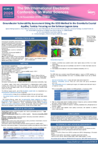
This study, carried out in the framework of the MedProgramme Project, presents an evaluation of the intrinsic vulnerability of the Grombalia coastal aquifer in northeastern Tunisia using the GOD method, with particular attention to the Soliman Lagoon zone. The GOD method—based on Groundwater occurrence (G), Overall lithology of the unsaturated zone (O), and Depth to water table (D)—provides a qualitative framework for identifying zones most susceptible to contamination. The Grombalia aquifer system is under increasing pressure from intensive agriculture, urban expansion, and saline water intrusion, particularly near the Soliman Lagoon, a sensitive interface between groundwater and coastal ecosystems.
The resulting vulnerability map shows a spatial variation ranging from low to high vulnerability, with the highest risk zones concentrated along the Soliman Lagoon’s southern perimeter. These areas are characterized by shallow phreatic levels, highly permeable lithologies (sands and silty sands), and limited natural protective layers. The GOD index values in these high-risk zones exceed 0.6, placing them in the moderate-to-high vulnerability category. In contrast, more inland zones with deeper water tables and less permeable overburden exhibit lower vulnerability scores.
The findings underscore the necessity for integrated groundwater protection measures, especially in the lagoon’s vicinity, where both ecological and socioeconomic stakes are high. This study supports the implementation of land-use regulation, monitoring programs, and pollution mitigation strategies aimed at preserving water quality and ensuring the long-term sustainability of the aquifer system.
Keywords
Coastal aquifer
GOD method
Grombalia aquifer
Soliman Lagoon
Tunisia
MedProgramme Project.
Poster
GOD.pdf
Analysis of phthalate emissions in the aquatic environment originating from PVC-based polymeric materials
Reconstruction of Flooding Patterns in Endorheic Lagoons of Semi-Arid Zones Using Satellite Imagery, Historical Data, and Water Balance Models: A Case Study from the LIFE IP Duero Project