Event submissions
Published
This submission belongs to the session S5. Extreme Hydro-meteorological Events: Sources, Mitigation and Adaptation of the event The 9th International Electronic Conference on Water Sciences
Published date
06 Nov, 2025
Academic Editor
'%3e%3cpath%20d='M12.6657%2010.9104C12.4185%2010.325%2012.0599%209.79327%2011.6097%209.34482C11.1609%208.89508%2010.6293%208.5365%2010.0442%208.28888C10.0389%208.28626%2010.0337%208.28495%2010.0285%208.28233C10.8446%207.69279%2011.3752%206.73249%2011.3752%205.64904C11.3752%203.8542%209.92103%202.39999%208.1262%202.39999C6.33136%202.39999%204.87715%203.8542%204.87715%205.64904C4.87715%206.73249%205.40774%207.69279%206.22393%208.28364C6.21869%208.28626%206.21345%208.28757%206.20821%208.29019C5.62129%208.5378%205.09463%208.89284%204.64265%209.34613C4.1929%209.79493%203.83432%2010.3266%203.58671%2010.9117C3.34345%2011.4845%203.21226%2012.0987%203.20023%2012.7209C3.19988%2012.7349%203.20233%2012.7488%203.20744%2012.7619C3.21255%2012.7749%203.22022%2012.7867%203.22998%2012.7968C3.23975%2012.8068%203.25142%2012.8147%203.26431%2012.8202C3.2772%2012.8256%203.29105%2012.8284%203.30504%2012.8284H4.09109C4.14874%2012.8284%204.19459%2012.7825%204.1959%2012.7262C4.2221%2011.7148%204.62823%2010.7676%205.34617%2010.0497C6.08899%209.30683%207.0755%208.89808%208.1262%208.89808C9.17689%208.89808%2010.1634%209.30683%2010.9062%2010.0497C11.6242%2010.7676%2012.0303%2011.7148%2012.0565%2012.7262C12.0578%2012.7838%2012.1037%2012.8284%2012.1613%2012.8284H12.9474C12.9613%2012.8284%2012.9752%2012.8256%2012.9881%2012.8202C13.001%2012.8147%2013.0126%2012.8068%2013.0224%2012.7968C13.0322%2012.7867%2013.0398%2012.7749%2013.0449%2012.7619C13.0501%2012.7488%2013.0525%2012.7349%2013.0522%2012.7209C13.0391%2012.0947%2012.9094%2011.4855%2012.6657%2010.9104ZM8.1262%207.9024C7.52486%207.9024%206.9589%207.6679%206.53312%207.24211C6.10733%206.81633%205.87283%206.25037%205.87283%205.64904C5.87283%205.0477%206.10733%204.48174%206.53312%204.05596C6.9589%203.63018%207.52486%203.39567%208.1262%203.39567C8.72753%203.39567%209.29349%203.63018%209.71927%204.05596C10.1451%204.48174%2010.3796%205.0477%2010.3796%205.64904C10.3796%206.25037%2010.1451%206.81633%209.71927%207.24211C9.29349%207.6679%208.72753%207.9024%208.1262%207.9024Z'%20fill='%235D1EE1'/%3e%3c/g%3e%3c/svg%3e) Lampros Vasiliades
Lampros VasiliadesCitation
Md. Shahriar, Sujoy Dey, Farhan Shahriure, Md. Jobayer Islam, Md. Jubayer Ahamed, S. M. Tasin Zahid, S. M. Firdous Siddiquee, Md. Aminul Islam, Md. Masud Rana, Navid Hasan, Deluar Hossain, Multi-Scale Hydro-meteorological Assessment of Extreme Flooding Events: The Case of Bangladesh's Eastern Deltaic Region, in Proceedings of The 9th International Electronic Conference on Water Sciences, 11 November–14 November 2025, MDPI: Basel, Switzerland
Share
Email
Facebook
Twitter
LinkedIn
Multi-Scale Hydro-meteorological Assessment of Extreme Flooding Events: The Case of Bangladesh's Eastern Deltaic Region
'%3e%3cpath%20d='M12.6647%2010.9104C12.4176%2010.325%2012.0589%209.7933%2011.6088%209.34485C11.16%208.89511%2010.6283%208.53653%2010.0432%208.28891C10.038%208.28629%2010.0327%208.28498%2010.0275%208.28236C10.8437%207.69282%2011.3743%206.73252%2011.3743%205.64907C11.3743%203.85423%209.92005%202.40002%208.12522%202.40002C6.33038%202.40002%204.87618%203.85423%204.87618%205.64907C4.87618%206.73252%205.40677%207.69282%206.22296%208.28367C6.21772%208.28629%206.21248%208.2876%206.20724%208.29022C5.62031%208.53783%205.09365%208.89287%204.64167%209.34616C4.19192%209.79496%203.83334%2010.3266%203.58573%2010.9117C3.34247%2011.4846%203.21128%2012.0987%203.19925%2012.721C3.1989%2012.735%203.20135%2012.7489%203.20646%2012.7619C3.21157%2012.7749%203.21924%2012.7868%203.22901%2012.7968C3.23877%2012.8068%203.25045%2012.8148%203.26334%2012.8202C3.27623%2012.8256%203.29007%2012.8284%203.30406%2012.8284H4.09012C4.14776%2012.8284%204.19362%2012.7825%204.19493%2012.7262C4.22113%2011.7148%204.62726%2010.7676%205.34519%2010.0497C6.08802%209.30686%207.07452%208.89811%208.12522%208.89811C9.17592%208.89811%2010.1624%209.30686%2010.9052%2010.0497C11.6232%2010.7676%2012.0293%2011.7148%2012.0555%2012.7262C12.0568%2012.7839%2012.1027%2012.8284%2012.1603%2012.8284H12.9464C12.9604%2012.8284%2012.9742%2012.8256%2012.9871%2012.8202C13%2012.8148%2013.0117%2012.8068%2013.0214%2012.7968C13.0312%2012.7868%2013.0389%2012.7749%2013.044%2012.7619C13.0491%2012.7489%2013.0515%2012.735%2013.0512%2012.721C13.0381%2012.0947%2012.9084%2011.4856%2012.6647%2010.9104ZM8.12522%207.90243C7.52388%207.90243%206.95792%207.66793%206.53214%207.24215C6.10636%206.81636%205.87185%206.2504%205.87185%205.64907C5.87185%205.04773%206.10636%204.48177%206.53214%204.05599C6.95792%203.63021%207.52388%203.3957%208.12522%203.3957C8.72655%203.3957%209.29252%203.63021%209.7183%204.05599C10.1441%204.48177%2010.3786%205.04773%2010.3786%205.64907C10.3786%206.2504%2010.1441%206.81636%209.7183%207.24215C9.29252%207.66793%208.72655%207.90243%208.12522%207.90243Z'%20fill='%235D1EE1'/%3e%3c/g%3e%3c/svg%3e)
Md. Shahriar 1
Sujoy Dey 1
Farhan Shahriure 1
Md. Jobayer Islam 1
Md. Jubayer Ahamed 1
S. M. Tasin Zahid 1
S. M. Firdous Siddiquee 1
Md. Aminul Islam 1
Md. Masud Rana 1
Navid Hasan 1
Deluar Hossain 1
1. Department of Water Resources Engineering, Bangladesh University of Engineering and Technology, Dhaka 1000, Bangladesh.
Abstract
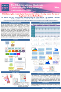
Flash flooding in Bangladesh’s eastern and southeastern deltaic districts, including Feni, Cumilla, Brahmanbaria, Chattogram, Khagrachhari, Noakhali, Lakshmipur, Moulvibazar, Habiganj, Sylhet, and Cox’s Bazar, during August 2024, left nearly 5.7 million people affected and at least 23 dead. Using the HEC-HMS hydrological model and discharge data from four stations (SW110, SW212, SW334, and SW84.1), the events were simulated with satisfactory accuracy, with Nash-Sutcliffe efficiency values of 0.65–0.75 and percent bias between +2% and –10%. Meteorological analysis indicates that the disaster was triggered by extreme cloud concentration and convective cloudbursts, driven by the interaction of cold air masses from the west, a Bay of Bengal low-pressure system, and an intensified monsoon trough. These conditions produced 180–610 mm of rainfall within 3–4 days, while Tripura’s steep topography accelerated runoff into downstream Bangladesh. Simultaneously, the full moon on 19 August coincided with spring tides in the Bay of Bengal, causing exceptionally high sea levels that delayed the drainage of floodwaters into the ocean, confirmed by the Delft3D model. Historical patterns show that when floods occur around new or full moon phases, tidal surges slow river discharge, intensifying inundation and prolonging flood duration. Although water release from India’s Dumboor Dam on the Gomti River occurred at the same time, the modeling results indicate that natural hydro-meteorological drivers were dominant, while the dam’s contribution was negligible. However, the absence of early transboundary communication aggravated the crisis. The disaster devastated croplands, housing, and transport infrastructure, while government agencies, the armed forces, and volunteers mobilized coordinated relief operations. Neighboring Tripura also experienced parallel impacts, with 350–375 mm of rainfall recorded in South Tripura and Gomati. This study shows how cloud cover, geomorphology, and tides together intensify flash floods, highlighting the need for better early warnings, tidal-hydrology integration in forecasts, and stronger transboundary water governance.
Keywords
Bangladesh
HEC-HMS
hydrological modeling
cloudburst
spring tide
transboundary rivers
Poster
water3.pdf
Drought assessment in the Portaikos mountainous watershed (Thessaly, Greece) using ground-based and reanalysis data
Assessing the Impact of the 2024 Valencia Cut-off Low on Urban Mobility: Patterns, Routes, and Reconstruction Challenges