Event submissions
Published
This submission belongs to the session S7. Remote Sensing, Artificial Intelligence and New Technologies in Water Sciences of the event The 9th International Electronic Conference on Water Sciences
Published date
06 Nov, 2025
Academic Editor
'%3e%3cpath%20d='M12.6657%2010.9104C12.4185%2010.325%2012.0599%209.79327%2011.6097%209.34482C11.1609%208.89508%2010.6293%208.5365%2010.0442%208.28888C10.0389%208.28626%2010.0337%208.28495%2010.0285%208.28233C10.8446%207.69279%2011.3752%206.73249%2011.3752%205.64904C11.3752%203.8542%209.92103%202.39999%208.1262%202.39999C6.33136%202.39999%204.87715%203.8542%204.87715%205.64904C4.87715%206.73249%205.40774%207.69279%206.22393%208.28364C6.21869%208.28626%206.21345%208.28757%206.20821%208.29019C5.62129%208.5378%205.09463%208.89284%204.64265%209.34613C4.1929%209.79493%203.83432%2010.3266%203.58671%2010.9117C3.34345%2011.4845%203.21226%2012.0987%203.20023%2012.7209C3.19988%2012.7349%203.20233%2012.7488%203.20744%2012.7619C3.21255%2012.7749%203.22022%2012.7867%203.22998%2012.7968C3.23975%2012.8068%203.25142%2012.8147%203.26431%2012.8202C3.2772%2012.8256%203.29105%2012.8284%203.30504%2012.8284H4.09109C4.14874%2012.8284%204.19459%2012.7825%204.1959%2012.7262C4.2221%2011.7148%204.62823%2010.7676%205.34617%2010.0497C6.08899%209.30683%207.0755%208.89808%208.1262%208.89808C9.17689%208.89808%2010.1634%209.30683%2010.9062%2010.0497C11.6242%2010.7676%2012.0303%2011.7148%2012.0565%2012.7262C12.0578%2012.7838%2012.1037%2012.8284%2012.1613%2012.8284H12.9474C12.9613%2012.8284%2012.9752%2012.8256%2012.9881%2012.8202C13.001%2012.8147%2013.0126%2012.8068%2013.0224%2012.7968C13.0322%2012.7867%2013.0398%2012.7749%2013.0449%2012.7619C13.0501%2012.7488%2013.0525%2012.7349%2013.0522%2012.7209C13.0391%2012.0947%2012.9094%2011.4855%2012.6657%2010.9104ZM8.1262%207.9024C7.52486%207.9024%206.9589%207.6679%206.53312%207.24211C6.10733%206.81633%205.87283%206.25037%205.87283%205.64904C5.87283%205.0477%206.10733%204.48174%206.53312%204.05596C6.9589%203.63018%207.52486%203.39567%208.1262%203.39567C8.72753%203.39567%209.29349%203.63018%209.71927%204.05596C10.1451%204.48174%2010.3796%205.0477%2010.3796%205.64904C10.3796%206.25037%2010.1451%206.81633%209.71927%207.24211C9.29349%207.6679%208.72753%207.9024%208.1262%207.9024Z'%20fill='%235D1EE1'/%3e%3c/g%3e%3c/svg%3e) Nikiforos Samarinas
Nikiforos SamarinasCitation
Laleh Jafari, Ben Jarihani, Jack Koci, Stephanie Duce, Ioan Sanislave, Evaluating Sentinel-1 DEMs for Geospatial Applications: A Benchmark Study with Copernicus DEM, SRTM, and LiDAR, in Proceedings of The 9th International Electronic Conference on Water Sciences, 11 November–14 November 2025, MDPI: Basel, Switzerland
Share
Email
Facebook
Twitter
LinkedIn
Evaluating Sentinel-1 DEMs for Geospatial Applications: A Benchmark Study with Copernicus DEM, SRTM, and LiDAR
'%3e%3cpath%20d='M12.6647%2010.9104C12.4176%2010.325%2012.0589%209.7933%2011.6088%209.34485C11.16%208.89511%2010.6283%208.53653%2010.0432%208.28891C10.038%208.28629%2010.0327%208.28498%2010.0275%208.28236C10.8437%207.69282%2011.3743%206.73252%2011.3743%205.64907C11.3743%203.85423%209.92005%202.40002%208.12522%202.40002C6.33038%202.40002%204.87618%203.85423%204.87618%205.64907C4.87618%206.73252%205.40677%207.69282%206.22296%208.28367C6.21772%208.28629%206.21248%208.2876%206.20724%208.29022C5.62031%208.53783%205.09365%208.89287%204.64167%209.34616C4.19192%209.79496%203.83334%2010.3266%203.58573%2010.9117C3.34247%2011.4846%203.21128%2012.0987%203.19925%2012.721C3.1989%2012.735%203.20135%2012.7489%203.20646%2012.7619C3.21157%2012.7749%203.21924%2012.7868%203.22901%2012.7968C3.23877%2012.8068%203.25045%2012.8148%203.26334%2012.8202C3.27623%2012.8256%203.29007%2012.8284%203.30406%2012.8284H4.09012C4.14776%2012.8284%204.19362%2012.7825%204.19493%2012.7262C4.22113%2011.7148%204.62726%2010.7676%205.34519%2010.0497C6.08802%209.30686%207.07452%208.89811%208.12522%208.89811C9.17592%208.89811%2010.1624%209.30686%2010.9052%2010.0497C11.6232%2010.7676%2012.0293%2011.7148%2012.0555%2012.7262C12.0568%2012.7839%2012.1027%2012.8284%2012.1603%2012.8284H12.9464C12.9604%2012.8284%2012.9742%2012.8256%2012.9871%2012.8202C13%2012.8148%2013.0117%2012.8068%2013.0214%2012.7968C13.0312%2012.7868%2013.0389%2012.7749%2013.044%2012.7619C13.0491%2012.7489%2013.0515%2012.735%2013.0512%2012.721C13.0381%2012.0947%2012.9084%2011.4856%2012.6647%2010.9104ZM8.12522%207.90243C7.52388%207.90243%206.95792%207.66793%206.53214%207.24215C6.10636%206.81636%205.87185%206.2504%205.87185%205.64907C5.87185%205.04773%206.10636%204.48177%206.53214%204.05599C6.95792%203.63021%207.52388%203.3957%208.12522%203.3957C8.72655%203.3957%209.29252%203.63021%209.7183%204.05599C10.1441%204.48177%2010.3786%205.04773%2010.3786%205.64907C10.3786%206.2504%2010.1441%206.81636%209.7183%207.24215C9.29252%207.66793%208.72655%207.90243%208.12522%207.90243Z'%20fill='%235D1EE1'/%3e%3c/g%3e%3c/svg%3e)
Laleh Jafari 1

Ben Jarihani 1
Jack Koci 2
Stephanie Duce 1
Ioan Sanislave 1
1. Earth and Environmental Science Department, College of Science and Engineering, James Cook University, Douglas 4811, Australia
2. TropWATER, James Cook University, Queensland 4811, Australia
Abstract
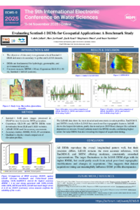
Digital Elevation Models (DEMs) underpin watershed delineation, landform classification, hydrologic/hydrodynamic modelling, and environmental monitoring. While SRTM (~30 m) is a common global baseline, advances in SAR processing (e.g., SNAP) enable locally tailored DEMs from Sentinel-1 interferometry. This study generates a Sentinel-1 InSAR DEM and evaluates it against Copernicus DEM (GLO-30, ~30 m DSM), SRTM (1-arcsec, ~30 m DEM), and very-high-resolution LiDAR patches over the study area. We assess accuracy using RMSE, MAE, and correlation (stratified by land cover, slope, and coherence), and qualitatively via elevation profiles, slope/aspect, and planform inspection. We diagnose error sources—temporal decorrelation, atmospheric delay, and baseline geometry—and examine long-wavelength ramps to gauge the benefit of stacking multiple interferograms. Results: The Sentinel-1 DEM provides enhanced local detail (≈10–30 m posting) and sharper terrain expression than global products on open to moderately vegetated slopes, but its performance degrades in dense vegetation/low-coherence zones. Published comparisons indicate that Copernicus GLO-30 typically outperforms SRTM by ~1–2 m RMSE, with global assessments showing most GLO-30 tiles <~1.2 m RMSE against space-borne lidar references. In contrast, single-pair Sentinel-1 InSAR DEMs in humid, vegetated tropics can show RMSE in the tens of metres (e.g., ~22.5 m), though stacking multiple interferograms improves accuracy relative to single-pair results. SRTM offers a smoother, more conservative surface but misses fine relief; Copernicus generally improves vertical consistency and landform depiction. LiDAR patches show the upper bound on accuracy and reveal local biases across coarse DEMs. We propose a practical selection framework—favouring Sentinel-1 for local detail/recent acquisitions, Copernicus for global consistency, SRTM for baseline coverage, and fusion with LiDAR where available—and outline integration steps for hydrologic/hydrodynamic and geomorphic change applications.
Keywords
Remote sensing
DEM
SRTM
LiDAR
SNAP
Poster
Laleh.Jafari_The 9th International Electronic Conference on Water Sciences.pdf
Utilizing Sulfate Radical-based Advanced Oxidation Processes for the Degradation of Textile Dye Reactive Blue 19
Microplastic–Microalgae Interactions: Effects on Nutrient Uptake and Growth of Chlorella vulgaris