Event submissions
Published
This submission belongs to the session S7. Remote Sensing, Artificial Intelligence and New Technologies in Water Sciences of the event The 9th International Electronic Conference on Water Sciences
Published date
06 Nov, 2025
Academic Editor
'%3e%3cpath%20d='M12.6657%2010.9104C12.4185%2010.325%2012.0599%209.79327%2011.6097%209.34482C11.1609%208.89508%2010.6293%208.5365%2010.0442%208.28888C10.0389%208.28626%2010.0337%208.28495%2010.0285%208.28233C10.8446%207.69279%2011.3752%206.73249%2011.3752%205.64904C11.3752%203.8542%209.92103%202.39999%208.1262%202.39999C6.33136%202.39999%204.87715%203.8542%204.87715%205.64904C4.87715%206.73249%205.40774%207.69279%206.22393%208.28364C6.21869%208.28626%206.21345%208.28757%206.20821%208.29019C5.62129%208.5378%205.09463%208.89284%204.64265%209.34613C4.1929%209.79493%203.83432%2010.3266%203.58671%2010.9117C3.34345%2011.4845%203.21226%2012.0987%203.20023%2012.7209C3.19988%2012.7349%203.20233%2012.7488%203.20744%2012.7619C3.21255%2012.7749%203.22022%2012.7867%203.22998%2012.7968C3.23975%2012.8068%203.25142%2012.8147%203.26431%2012.8202C3.2772%2012.8256%203.29105%2012.8284%203.30504%2012.8284H4.09109C4.14874%2012.8284%204.19459%2012.7825%204.1959%2012.7262C4.2221%2011.7148%204.62823%2010.7676%205.34617%2010.0497C6.08899%209.30683%207.0755%208.89808%208.1262%208.89808C9.17689%208.89808%2010.1634%209.30683%2010.9062%2010.0497C11.6242%2010.7676%2012.0303%2011.7148%2012.0565%2012.7262C12.0578%2012.7838%2012.1037%2012.8284%2012.1613%2012.8284H12.9474C12.9613%2012.8284%2012.9752%2012.8256%2012.9881%2012.8202C13.001%2012.8147%2013.0126%2012.8068%2013.0224%2012.7968C13.0322%2012.7867%2013.0398%2012.7749%2013.0449%2012.7619C13.0501%2012.7488%2013.0525%2012.7349%2013.0522%2012.7209C13.0391%2012.0947%2012.9094%2011.4855%2012.6657%2010.9104ZM8.1262%207.9024C7.52486%207.9024%206.9589%207.6679%206.53312%207.24211C6.10733%206.81633%205.87283%206.25037%205.87283%205.64904C5.87283%205.0477%206.10733%204.48174%206.53312%204.05596C6.9589%203.63018%207.52486%203.39567%208.1262%203.39567C8.72753%203.39567%209.29349%203.63018%209.71927%204.05596C10.1451%204.48174%2010.3796%205.0477%2010.3796%205.64904C10.3796%206.25037%2010.1451%206.81633%209.71927%207.24211C9.29349%207.6679%208.72753%207.9024%208.1262%207.9024Z'%20fill='%235D1EE1'/%3e%3c/g%3e%3c/svg%3e) Nikiforos Samarinas
Nikiforos SamarinasCitation
Sandunika Rathnayake, Ben Jarihani, Remote Sensing-Based Water Balance Assessment of the Syr Darya and Amu Darya Basins, in Proceedings of The 9th International Electronic Conference on Water Sciences, 11 November–14 November 2025, MDPI: Basel, Switzerland
Share
Email
Facebook
Twitter
LinkedIn
Remote Sensing-Based Water Balance Assessment of the Syr Darya and Amu Darya Basins
'%3e%3cpath%20d='M12.6647%2010.9104C12.4176%2010.325%2012.0589%209.7933%2011.6088%209.34485C11.16%208.89511%2010.6283%208.53653%2010.0432%208.28891C10.038%208.28629%2010.0327%208.28498%2010.0275%208.28236C10.8437%207.69282%2011.3743%206.73252%2011.3743%205.64907C11.3743%203.85423%209.92005%202.40002%208.12522%202.40002C6.33038%202.40002%204.87618%203.85423%204.87618%205.64907C4.87618%206.73252%205.40677%207.69282%206.22296%208.28367C6.21772%208.28629%206.21248%208.2876%206.20724%208.29022C5.62031%208.53783%205.09365%208.89287%204.64167%209.34616C4.19192%209.79496%203.83334%2010.3266%203.58573%2010.9117C3.34247%2011.4846%203.21128%2012.0987%203.19925%2012.721C3.1989%2012.735%203.20135%2012.7489%203.20646%2012.7619C3.21157%2012.7749%203.21924%2012.7868%203.22901%2012.7968C3.23877%2012.8068%203.25045%2012.8148%203.26334%2012.8202C3.27623%2012.8256%203.29007%2012.8284%203.30406%2012.8284H4.09012C4.14776%2012.8284%204.19362%2012.7825%204.19493%2012.7262C4.22113%2011.7148%204.62726%2010.7676%205.34519%2010.0497C6.08802%209.30686%207.07452%208.89811%208.12522%208.89811C9.17592%208.89811%2010.1624%209.30686%2010.9052%2010.0497C11.6232%2010.7676%2012.0293%2011.7148%2012.0555%2012.7262C12.0568%2012.7839%2012.1027%2012.8284%2012.1603%2012.8284H12.9464C12.9604%2012.8284%2012.9742%2012.8256%2012.9871%2012.8202C13%2012.8148%2013.0117%2012.8068%2013.0214%2012.7968C13.0312%2012.7868%2013.0389%2012.7749%2013.044%2012.7619C13.0491%2012.7489%2013.0515%2012.735%2013.0512%2012.721C13.0381%2012.0947%2012.9084%2011.4856%2012.6647%2010.9104ZM8.12522%207.90243C7.52388%207.90243%206.95792%207.66793%206.53214%207.24215C6.10636%206.81636%205.87185%206.2504%205.87185%205.64907C5.87185%205.04773%206.10636%204.48177%206.53214%204.05599C6.95792%203.63021%207.52388%203.3957%208.12522%203.3957C8.72655%203.3957%209.29252%203.63021%209.7183%204.05599C10.1441%204.48177%2010.3786%205.04773%2010.3786%205.64907C10.3786%206.2504%2010.1441%206.81636%209.7183%207.24215C9.29252%207.66793%208.72655%207.90243%208.12522%207.90243Z'%20fill='%235D1EE1'/%3e%3c/g%3e%3c/svg%3e)
Sandunika Rathnayake 1

Ben Jarihani 2
1. Department of Earth Resources Engineering, Faculty of Engineering, University of Moratuwa, Moratuwa 10400, Sri Lanka
2. Earth and Environmental Sciences, College of Science and Engineering, James Cook University 4811, Townsville, Australia
Abstract
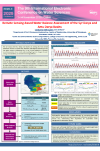
The Syr Darya and Amu Darya rivers in Central Asia are critical water sources for the region. However, hydrological monitoring remains challenging due to limited ground-based observations. In this study, we applied a fully remote sensing-based approach to quantify the water balance dynamics of these two large catchments from 2003 to 2024.
We utilized total water storage anomalies (TWSA) from GRACE and GRACE-FO, satellite-based precipitation (P) from CHIRPS, and actual evapotranspiration (AET) from MODIS. Monthly water balance components were assessed, with precipitation representing input, evapotranspiration representing loss, and GRACE-derived TWSA reflecting residual storage changes.
The results reveal a strong correlation between P–AET and GRACE-derived storage changes, confirming that satellite observations can effectively track basin-scale water balance in data-scarce regions. Nonetheless, divergences are observed in certain months, particularly during winter and spring, likely due to contributions from snow accumulation and subsequent melt. Runoff data from ERA5-Land further show a sharp increase from April to June, highlighting the influence of spring snowmelt. Seasonal analysis illustrates storage gains during winter due to precipitation and snow accumulation, followed by depletion in spring–summer driven by evapotranspiration and water withdrawals.
This study demonstrates the potential of integrating multiple satellite datasets to monitor hydrological variability in the Syr Darya and Amu Darya basins. This approach provides a solid framework for supporting water resource management and offers new insights into how climate variability affects water availability in Central Asia.
Keywords
Water balance
Remote sensing
Central Asia
GRACE
Total water storage anomalies
Poster
Poster_sciforum-153204.pdf
A Citizen Science and Crowdsourcing Framework for Community-Led Water Security Monitoring
Next-Generation Water Management: Integrating Generative and Agentic AI for Enhanced Efficiency and Resilience