Event submissions
Published
This submission belongs to the session B. Coastal Engineering of the event The 1st International Online Conference on Marine Science and Engineering
Published date
19 Nov, 2025
Academic Editor
'%3e%3cpath%20d='M12.6657%2010.9104C12.4185%2010.325%2012.0599%209.79327%2011.6097%209.34482C11.1609%208.89508%2010.6293%208.5365%2010.0442%208.28888C10.0389%208.28626%2010.0337%208.28495%2010.0285%208.28233C10.8446%207.69279%2011.3752%206.73249%2011.3752%205.64904C11.3752%203.8542%209.92103%202.39999%208.1262%202.39999C6.33136%202.39999%204.87715%203.8542%204.87715%205.64904C4.87715%206.73249%205.40774%207.69279%206.22393%208.28364C6.21869%208.28626%206.21345%208.28757%206.20821%208.29019C5.62129%208.5378%205.09463%208.89284%204.64265%209.34613C4.1929%209.79493%203.83432%2010.3266%203.58671%2010.9117C3.34345%2011.4845%203.21226%2012.0987%203.20023%2012.7209C3.19988%2012.7349%203.20233%2012.7488%203.20744%2012.7619C3.21255%2012.7749%203.22022%2012.7867%203.22998%2012.7968C3.23975%2012.8068%203.25142%2012.8147%203.26431%2012.8202C3.2772%2012.8256%203.29105%2012.8284%203.30504%2012.8284H4.09109C4.14874%2012.8284%204.19459%2012.7825%204.1959%2012.7262C4.2221%2011.7148%204.62823%2010.7676%205.34617%2010.0497C6.08899%209.30683%207.0755%208.89808%208.1262%208.89808C9.17689%208.89808%2010.1634%209.30683%2010.9062%2010.0497C11.6242%2010.7676%2012.0303%2011.7148%2012.0565%2012.7262C12.0578%2012.7838%2012.1037%2012.8284%2012.1613%2012.8284H12.9474C12.9613%2012.8284%2012.9752%2012.8256%2012.9881%2012.8202C13.001%2012.8147%2013.0126%2012.8068%2013.0224%2012.7968C13.0322%2012.7867%2013.0398%2012.7749%2013.0449%2012.7619C13.0501%2012.7488%2013.0525%2012.7349%2013.0522%2012.7209C13.0391%2012.0947%2012.9094%2011.4855%2012.6657%2010.9104ZM8.1262%207.9024C7.52486%207.9024%206.9589%207.6679%206.53312%207.24211C6.10733%206.81633%205.87283%206.25037%205.87283%205.64904C5.87283%205.0477%206.10733%204.48174%206.53312%204.05596C6.9589%203.63018%207.52486%203.39567%208.1262%203.39567C8.72753%203.39567%209.29349%203.63018%209.71927%204.05596C10.1451%204.48174%2010.3796%205.0477%2010.3796%205.64904C10.3796%206.25037%2010.1451%206.81633%209.71927%207.24211C9.29349%207.6679%208.72753%207.9024%208.1262%207.9024Z'%20fill='%235D1EE1'/%3e%3c/g%3e%3c/svg%3e) Rafael J. Bergillos
Rafael J. BergillosCitation
Francesca Iacono, Daniele Trippanera, Tommaso Alberti, Marina Bisson, Alessandro Bosman, Carlo Alberto Brunori, Marco Anzidei, Sea-Level Rise Scenarios up to 2150 for the Tuscany Coast: The Case of the Northern Sector, in Proceedings of The 1st International Online Conference on Marine Science and Engineering, 24 November–26 November 2025, MDPI: Basel, Switzerland
Share
Email
Facebook
Twitter
LinkedIn
Sea-Level Rise Scenarios up to 2150 for the Tuscany Coast: The Case of the Northern Sector
'%3e%3cpath%20d='M12.6647%2010.9104C12.4176%2010.325%2012.0589%209.7933%2011.6088%209.34485C11.16%208.89511%2010.6283%208.53653%2010.0432%208.28891C10.038%208.28629%2010.0327%208.28498%2010.0275%208.28236C10.8437%207.69282%2011.3743%206.73252%2011.3743%205.64907C11.3743%203.85423%209.92005%202.40002%208.12522%202.40002C6.33038%202.40002%204.87618%203.85423%204.87618%205.64907C4.87618%206.73252%205.40677%207.69282%206.22296%208.28367C6.21772%208.28629%206.21248%208.2876%206.20724%208.29022C5.62031%208.53783%205.09365%208.89287%204.64167%209.34616C4.19192%209.79496%203.83334%2010.3266%203.58573%2010.9117C3.34247%2011.4846%203.21128%2012.0987%203.19925%2012.721C3.1989%2012.735%203.20135%2012.7489%203.20646%2012.7619C3.21157%2012.7749%203.21924%2012.7868%203.22901%2012.7968C3.23877%2012.8068%203.25045%2012.8148%203.26334%2012.8202C3.27623%2012.8256%203.29007%2012.8284%203.30406%2012.8284H4.09012C4.14776%2012.8284%204.19362%2012.7825%204.19493%2012.7262C4.22113%2011.7148%204.62726%2010.7676%205.34519%2010.0497C6.08802%209.30686%207.07452%208.89811%208.12522%208.89811C9.17592%208.89811%2010.1624%209.30686%2010.9052%2010.0497C11.6232%2010.7676%2012.0293%2011.7148%2012.0555%2012.7262C12.0568%2012.7839%2012.1027%2012.8284%2012.1603%2012.8284H12.9464C12.9604%2012.8284%2012.9742%2012.8256%2012.9871%2012.8202C13%2012.8148%2013.0117%2012.8068%2013.0214%2012.7968C13.0312%2012.7868%2013.0389%2012.7749%2013.044%2012.7619C13.0491%2012.7489%2013.0515%2012.735%2013.0512%2012.721C13.0381%2012.0947%2012.9084%2011.4856%2012.6647%2010.9104ZM8.12522%207.90243C7.52388%207.90243%206.95792%207.66793%206.53214%207.24215C6.10636%206.81636%205.87185%206.2504%205.87185%205.64907C5.87185%205.04773%206.10636%204.48177%206.53214%204.05599C6.95792%203.63021%207.52388%203.3957%208.12522%203.3957C8.72655%203.3957%209.29252%203.63021%209.7183%204.05599C10.1441%204.48177%2010.3786%205.04773%2010.3786%205.64907C10.3786%206.2504%2010.1441%206.81636%209.7183%207.24215C9.29252%207.66793%208.72655%207.90243%208.12522%207.90243Z'%20fill='%235D1EE1'/%3e%3c/g%3e%3c/svg%3e)
Francesca Iacono 1
Daniele Trippanera 2

Tommaso Alberti 3

Marina Bisson 1
Alessandro Bosman 4
Carlo Alberto Brunori 3

Marco Anzidei 2
1. Istituto Nazionale di Geofisica e Vulcanologia, Sezione di Pisa, Via Cesare Battisti 53, 56125 Pisa, Italy
2. Istituto Nazionale di Geofisica e Vulcanologia, Sezione Osservatorio Nazionale Terremoti, Roma, Italy
3. Istituto Nazionale di Geofisica e Vulcanologia, Roma, Italy
4. Istituto di Geologia Ambientale e Geoingegneria, Consiglio Nazionale Delle Ricerche, CNR-IGAG, RU Sapienza DICEA, Roma, Italy
Abstract
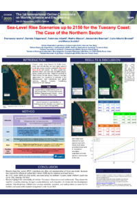
Coastal zones, long favored for fertile lands, trade, and mild climates, are now highly exposed to climate change impacts, particularly sea-level rise (SLR) scenarios and erosion. By 2060, global low-elevation areas may host over one billion people, facing growing flood risks. Regional sea level is influenced by climatic drivers, tectonics, isostatic adjustments, and circulation. In particular, in the Mediterranean, land subsidence and global warming intensify hazards, threatening infrastructure and heritage. This study examines future SLR along the Northern Tuscany coast, between Pisa and Massa-Carrara, to support adaptation strategies.
A multidisciplinary study was launched to project local SLR and generate flood maps up to 2150 using sea-level data from local stations (PSMSL; ISPRA) and vertical land motion as derived from GNSS networks and MT-InSAR data analysis. High-resolution LiDAR topography (2008–2010), referenced to the ITALGEO 2005 geoid, supported inundation mapping. Results were combined with IPCC-AR6 projections under the high-emission SSP5-8.5 scenario. Local subsidence was considered, assuming no major tectonic or volcanic events.
By 2150, under SSP5-8.5, sea levels along the Northern Tuscany coast (465km²) could rise up to 1.5m, flooding 170.7km². Estimates were obtained using a passive approach, where land below the projected water level is considered inundated, regardless of direct sea connection.
The results highlight the vulnerability of Northern Tuscany’s infrastructure and settlements. They stress the need for proactive planning, stronger coastal defenses, and integration of climate risk into development policies. Interdisciplinary collaboration among scientists, planners, and policymakers is essential for resilient and sustainable coastal management under future SLR.
Keywords
Sea-level rise
flood maps
vulnerability
Tuscany coast
Poster
poster_Iaconoetal.pdf
The Impact of Procedural Factors on Granulometric Analysis: Implications for the Economic Viability and Success of Coastal Nourishment Projects
Physical modelling of wave overtopping mitigation through adaptive defence solutions