Event submissions
Published
This submission belongs to the session S3. Computing and Artificial Intelligence of the event The 6th International Electronic Conference on Applied Sciences
Published date
03 Dec, 2025
Academic Editor
'%3e%3cpath%20d='M12.6657%2010.9104C12.4185%2010.325%2012.0599%209.79327%2011.6097%209.34482C11.1609%208.89508%2010.6293%208.5365%2010.0442%208.28888C10.0389%208.28626%2010.0337%208.28495%2010.0285%208.28233C10.8446%207.69279%2011.3752%206.73249%2011.3752%205.64904C11.3752%203.8542%209.92103%202.39999%208.1262%202.39999C6.33136%202.39999%204.87715%203.8542%204.87715%205.64904C4.87715%206.73249%205.40774%207.69279%206.22393%208.28364C6.21869%208.28626%206.21345%208.28757%206.20821%208.29019C5.62129%208.5378%205.09463%208.89284%204.64265%209.34613C4.1929%209.79493%203.83432%2010.3266%203.58671%2010.9117C3.34345%2011.4845%203.21226%2012.0987%203.20023%2012.7209C3.19988%2012.7349%203.20233%2012.7488%203.20744%2012.7619C3.21255%2012.7749%203.22022%2012.7867%203.22998%2012.7968C3.23975%2012.8068%203.25142%2012.8147%203.26431%2012.8202C3.2772%2012.8256%203.29105%2012.8284%203.30504%2012.8284H4.09109C4.14874%2012.8284%204.19459%2012.7825%204.1959%2012.7262C4.2221%2011.7148%204.62823%2010.7676%205.34617%2010.0497C6.08899%209.30683%207.0755%208.89808%208.1262%208.89808C9.17689%208.89808%2010.1634%209.30683%2010.9062%2010.0497C11.6242%2010.7676%2012.0303%2011.7148%2012.0565%2012.7262C12.0578%2012.7838%2012.1037%2012.8284%2012.1613%2012.8284H12.9474C12.9613%2012.8284%2012.9752%2012.8256%2012.9881%2012.8202C13.001%2012.8147%2013.0126%2012.8068%2013.0224%2012.7968C13.0322%2012.7867%2013.0398%2012.7749%2013.0449%2012.7619C13.0501%2012.7488%2013.0525%2012.7349%2013.0522%2012.7209C13.0391%2012.0947%2012.9094%2011.4855%2012.6657%2010.9104ZM8.1262%207.9024C7.52486%207.9024%206.9589%207.6679%206.53312%207.24211C6.10733%206.81633%205.87283%206.25037%205.87283%205.64904C5.87283%205.0477%206.10733%204.48174%206.53312%204.05596C6.9589%203.63018%207.52486%203.39567%208.1262%203.39567C8.72753%203.39567%209.29349%203.63018%209.71927%204.05596C10.1451%204.48174%2010.3796%205.0477%2010.3796%205.64904C10.3796%206.25037%2010.1451%206.81633%209.71927%207.24211C9.29349%207.6679%208.72753%207.9024%208.1262%207.9024Z'%20fill='%235D1EE1'/%3e%3c/g%3e%3c/svg%3e) Lucia Billeci
Lucia BilleciCitation
Asma Haichour, Maroua Rezig, Mohammed El Amin Larabi, Meziane Iftene, ALSAT Satellite Imagery Enhancement using Generative Models for Forest Mapping, in Proceedings of The 6th International Electronic Conference on Applied Sciences, 9 December–11 December 2025, MDPI: Basel, Switzerland
Share
Email
Facebook
Twitter
LinkedIn
ALSAT Satellite Imagery Enhancement using Generative Models for Forest Mapping
'%3e%3cpath%20d='M12.6647%2010.9104C12.4176%2010.325%2012.0589%209.7933%2011.6088%209.34485C11.16%208.89511%2010.6283%208.53653%2010.0432%208.28891C10.038%208.28629%2010.0327%208.28498%2010.0275%208.28236C10.8437%207.69282%2011.3743%206.73252%2011.3743%205.64907C11.3743%203.85423%209.92005%202.40002%208.12522%202.40002C6.33038%202.40002%204.87618%203.85423%204.87618%205.64907C4.87618%206.73252%205.40677%207.69282%206.22296%208.28367C6.21772%208.28629%206.21248%208.2876%206.20724%208.29022C5.62031%208.53783%205.09365%208.89287%204.64167%209.34616C4.19192%209.79496%203.83334%2010.3266%203.58573%2010.9117C3.34247%2011.4846%203.21128%2012.0987%203.19925%2012.721C3.1989%2012.735%203.20135%2012.7489%203.20646%2012.7619C3.21157%2012.7749%203.21924%2012.7868%203.22901%2012.7968C3.23877%2012.8068%203.25045%2012.8148%203.26334%2012.8202C3.27623%2012.8256%203.29007%2012.8284%203.30406%2012.8284H4.09012C4.14776%2012.8284%204.19362%2012.7825%204.19493%2012.7262C4.22113%2011.7148%204.62726%2010.7676%205.34519%2010.0497C6.08802%209.30686%207.07452%208.89811%208.12522%208.89811C9.17592%208.89811%2010.1624%209.30686%2010.9052%2010.0497C11.6232%2010.7676%2012.0293%2011.7148%2012.0555%2012.7262C12.0568%2012.7839%2012.1027%2012.8284%2012.1603%2012.8284H12.9464C12.9604%2012.8284%2012.9742%2012.8256%2012.9871%2012.8202C13%2012.8148%2013.0117%2012.8068%2013.0214%2012.7968C13.0312%2012.7868%2013.0389%2012.7749%2013.044%2012.7619C13.0491%2012.7489%2013.0515%2012.735%2013.0512%2012.721C13.0381%2012.0947%2012.9084%2011.4856%2012.6647%2010.9104ZM8.12522%207.90243C7.52388%207.90243%206.95792%207.66793%206.53214%207.24215C6.10636%206.81636%205.87185%206.2504%205.87185%205.64907C5.87185%205.04773%206.10636%204.48177%206.53214%204.05599C6.95792%203.63021%207.52388%203.3957%208.12522%203.3957C8.72655%203.3957%209.29252%203.63021%209.7183%204.05599C10.1441%204.48177%2010.3786%205.04773%2010.3786%205.64907C10.3786%206.2504%2010.1441%206.81636%209.7183%207.24215C9.29252%207.66793%208.72655%207.90243%208.12522%207.90243Z'%20fill='%235D1EE1'/%3e%3c/g%3e%3c/svg%3e)
Asma Haichour 1
Maroua Rezig 1
Mohammed El Amin Larabi 2
Meziane Iftene 2
1. Departement of Artificial Intelligence and Data Sciences, École supérieure en Sciences et Technologies de l’Informatique et du Numérique, Béjaia, 06000, Algeria
2. Departement of Scientific and Technological Watch, Algerian Space Agency, Algiers, 16000, Algeria
Abstract
National satellite programs offer strategic autonomy but are often constrained by sensor hardware limitations. Algeria's ALSAT-2B satellite lacks the critical Short-Wave Infrared (SWIR) and Red-Edge spectral bands essential for quantitative forest monitoring, limiting the utility of this sovereign data asset. This research introduces a novel AI-driven framework to digitally enhance ALSAT-2B imagery, unlocking its full potential for national forest management (SDG 13 & 15).
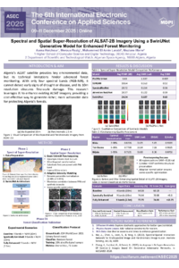
Our methodology employs a synergistic, two-stage process. Stage 1 (Spectral Enrichment): A Generative Adversarial Network (GAN) with a SwinUNet architecture was trained to synthetically reconstruct the five missing spectral bands by learning the relationship between ALSAT-2B and Sentinel-2 data. Stage 2 (Spatial Enhancement): The now nine-band data was fused with ALSAT-2B’s 2.5m panchromatic band using the Gram–Schmidt pansharpening algorithm, enhancing its spatial resolution.
The framework's efficacy was validated through a forest cover classification task. Results showed a dramatic improvement at each stage. The classification F1-Score on the baseline four-band, 10m ALSAT-2B data was 60.28%. After spectral enrichment, the score increased to 70.08%. The final, fully enhanced nine-band, 2.5m product achieved an F1-Score of 74.03%—a total improvement of nearly 14 percentage points.
This research presents a powerful framework for valorizing sovereign satellite data through AI. By successfully generating critical spectral bands and enhancing spatial detail, we can transform existing imagery into a high-value, analysis-ready product, providing Algerian institutions with a tangible, deployable methodology to significantly improve national forest monitoring and management.
Keywords
Spectral Super-Resolution
Pansharpening
Forest Monitoring
Generative Adversarial Network (GAN)
Poster
Spectral and Spatial Super-Resolution of ALSAT-2B Imagery Using a SwinUNet Generative Model for Enhanced Forest Monitoring.pdf
From an Analytical Formulation to a Digital Image Processing Strategy for Contour Hologram Synthesis
Detection of Coastal Geomorphological Changes Using Remote Sensing and GIS Techniques: A Case Study of Artificial Inlets of the Bardawil Lagoon, Egypt