Event submissions
Published
This submission belongs to the session S6. Energy, Environmental and Earth Science of the event The 6th International Electronic Conference on Applied Sciences
Published date
03 Dec, 2025
Academic Editor
'%3e%3cpath%20d='M12.6657%2010.9104C12.4185%2010.325%2012.0599%209.79327%2011.6097%209.34482C11.1609%208.89508%2010.6293%208.5365%2010.0442%208.28888C10.0389%208.28626%2010.0337%208.28495%2010.0285%208.28233C10.8446%207.69279%2011.3752%206.73249%2011.3752%205.64904C11.3752%203.8542%209.92103%202.39999%208.1262%202.39999C6.33136%202.39999%204.87715%203.8542%204.87715%205.64904C4.87715%206.73249%205.40774%207.69279%206.22393%208.28364C6.21869%208.28626%206.21345%208.28757%206.20821%208.29019C5.62129%208.5378%205.09463%208.89284%204.64265%209.34613C4.1929%209.79493%203.83432%2010.3266%203.58671%2010.9117C3.34345%2011.4845%203.21226%2012.0987%203.20023%2012.7209C3.19988%2012.7349%203.20233%2012.7488%203.20744%2012.7619C3.21255%2012.7749%203.22022%2012.7867%203.22998%2012.7968C3.23975%2012.8068%203.25142%2012.8147%203.26431%2012.8202C3.2772%2012.8256%203.29105%2012.8284%203.30504%2012.8284H4.09109C4.14874%2012.8284%204.19459%2012.7825%204.1959%2012.7262C4.2221%2011.7148%204.62823%2010.7676%205.34617%2010.0497C6.08899%209.30683%207.0755%208.89808%208.1262%208.89808C9.17689%208.89808%2010.1634%209.30683%2010.9062%2010.0497C11.6242%2010.7676%2012.0303%2011.7148%2012.0565%2012.7262C12.0578%2012.7838%2012.1037%2012.8284%2012.1613%2012.8284H12.9474C12.9613%2012.8284%2012.9752%2012.8256%2012.9881%2012.8202C13.001%2012.8147%2013.0126%2012.8068%2013.0224%2012.7968C13.0322%2012.7867%2013.0398%2012.7749%2013.0449%2012.7619C13.0501%2012.7488%2013.0525%2012.7349%2013.0522%2012.7209C13.0391%2012.0947%2012.9094%2011.4855%2012.6657%2010.9104ZM8.1262%207.9024C7.52486%207.9024%206.9589%207.6679%206.53312%207.24211C6.10733%206.81633%205.87283%206.25037%205.87283%205.64904C5.87283%205.0477%206.10733%204.48174%206.53312%204.05596C6.9589%203.63018%207.52486%203.39567%208.1262%203.39567C8.72753%203.39567%209.29349%203.63018%209.71927%204.05596C10.1451%204.48174%2010.3796%205.0477%2010.3796%205.64904C10.3796%206.25037%2010.1451%206.81633%209.71927%207.24211C9.29349%207.6679%208.72753%207.9024%208.1262%207.9024Z'%20fill='%235D1EE1'/%3e%3c/g%3e%3c/svg%3e) Simeone Chianese
Simeone ChianeseCitation
Kamal Srogy Darwish, Detection of Coastal Geomorphological Changes Using Remote Sensing and GIS Techniques: A Case Study of Artificial Inlets of the Bardawil Lagoon, Egypt, in Proceedings of The 6th International Electronic Conference on Applied Sciences, 9 December–11 December 2025, MDPI: Basel, Switzerland
Share
Email
Facebook
Twitter
LinkedIn
Detection of Coastal Geomorphological Changes Using Remote Sensing and GIS Techniques: A Case Study of Artificial Inlets of the Bardawil Lagoon, Egypt

Kamal Srogy Darwish 1
1. Department of Geography, Faculty of Arts, Minia University, Al Minya 61519, Egypt
Abstract
Coastal geomorphological changes significantly affect the environmental integrity and socio-economic resilience of vulnerable coastal zones. This study investigates the geomorphological evolution of the artificial inlets of Bardawil Lagoon, located along Egypt’s Mediterranean coast, using multi-temporal satellite remote sensing data from Landsat 8/9 (2015–2025) and digital elevation models (DEMs). The accuracy of digital image processing techniques was validated using high-resolution Google Earth imagery. Bardawil Lagoon, a critical ecological and coastal system, has undergone substantial changes driven by both anthropogenic activities and natural processes, including sediment transport, tidal fluctuations, and engineered inlet modifications. Spatiotemporal monitoring using satellite remote sensing has become a vital tool in recent decades for mapping and assessing coastal dynamics. In this study, high-resolution imagery was processed within a GIS-based framework to analyze shoreline change rates, inlet migration, sediment deposition within navigational canals, and the performance of coastal protection structures. The Digital Shoreline Analysis System (DSAS) was used to quantify shoreline retreat and advance. Results reveal significant morphological variability in the artificial inlets, characterized by pronounced eastward migration and seasonal sediment accumulation that influence lagoon connectivity and hydrodynamic behavior. This research underscores the effectiveness of integrating remote sensing and GIS for monitoring coastal inlet dynamics and provides critical insights for sustainable coastal management, infrastructure planning, and ecological conservation in semi-enclosed systems such as Bardawil Lagoon. The approach is adaptable to other coastal environments facing similar natural and anthropogenic pressures.
Keywords
Coastal Geomorphology
Remote Sensing
Artificial Inlets
Coastal Processes
DSAS
Mediterranean Coast
Poster
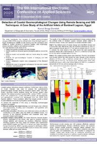
POSTER Conference ASEC 2025..pdf
ALSAT Satellite Imagery Enhancement using Generative Models for Forest Mapping
Explainable AI for Remote Sensing Image Processing: Advanced Interpretation Techniques for Agricultural Monitoring