Event submissions
Published
This submission belongs to the session S3. "New" Crops for Adaptation to Climate Change of the event The 5th International Electronic Conference on Agronomy
Published date
11 Dec, 2025
Academic Editor
'%3e%3cpath%20d='M12.6657%2010.9104C12.4185%2010.325%2012.0599%209.79327%2011.6097%209.34482C11.1609%208.89508%2010.6293%208.5365%2010.0442%208.28888C10.0389%208.28626%2010.0337%208.28495%2010.0285%208.28233C10.8446%207.69279%2011.3752%206.73249%2011.3752%205.64904C11.3752%203.8542%209.92103%202.39999%208.1262%202.39999C6.33136%202.39999%204.87715%203.8542%204.87715%205.64904C4.87715%206.73249%205.40774%207.69279%206.22393%208.28364C6.21869%208.28626%206.21345%208.28757%206.20821%208.29019C5.62129%208.5378%205.09463%208.89284%204.64265%209.34613C4.1929%209.79493%203.83432%2010.3266%203.58671%2010.9117C3.34345%2011.4845%203.21226%2012.0987%203.20023%2012.7209C3.19988%2012.7349%203.20233%2012.7488%203.20744%2012.7619C3.21255%2012.7749%203.22022%2012.7867%203.22998%2012.7968C3.23975%2012.8068%203.25142%2012.8147%203.26431%2012.8202C3.2772%2012.8256%203.29105%2012.8284%203.30504%2012.8284H4.09109C4.14874%2012.8284%204.19459%2012.7825%204.1959%2012.7262C4.2221%2011.7148%204.62823%2010.7676%205.34617%2010.0497C6.08899%209.30683%207.0755%208.89808%208.1262%208.89808C9.17689%208.89808%2010.1634%209.30683%2010.9062%2010.0497C11.6242%2010.7676%2012.0303%2011.7148%2012.0565%2012.7262C12.0578%2012.7838%2012.1037%2012.8284%2012.1613%2012.8284H12.9474C12.9613%2012.8284%2012.9752%2012.8256%2012.9881%2012.8202C13.001%2012.8147%2013.0126%2012.8068%2013.0224%2012.7968C13.0322%2012.7867%2013.0398%2012.7749%2013.0449%2012.7619C13.0501%2012.7488%2013.0525%2012.7349%2013.0522%2012.7209C13.0391%2012.0947%2012.9094%2011.4855%2012.6657%2010.9104ZM8.1262%207.9024C7.52486%207.9024%206.9589%207.6679%206.53312%207.24211C6.10733%206.81633%205.87283%206.25037%205.87283%205.64904C5.87283%205.0477%206.10733%204.48174%206.53312%204.05596C6.9589%203.63018%207.52486%203.39567%208.1262%203.39567C8.72753%203.39567%209.29349%203.63018%209.71927%204.05596C10.1451%204.48174%2010.3796%205.0477%2010.3796%205.64904C10.3796%206.25037%2010.1451%206.81633%209.71927%207.24211C9.29349%207.6679%208.72753%207.9024%208.1262%207.9024Z'%20fill='%235D1EE1'/%3e%3c/g%3e%3c/svg%3e) Helder Fraga
Helder FragaCitation
Abdelmejid Rahimi, Ikram El Mjiri, Abdelkrim Bouasria, Mohammed Bounif, Using Google Earth Engine to assess the impacts of climate change on land use in the Gheris watershed, Morocco, in Proceedings of The 5th International Electronic Conference on Agronomy, 15 December–18 December 2025, MDPI: Basel, Switzerland
Share
Email
Facebook
Twitter
LinkedIn
Using Google Earth Engine to assess the impacts of climate change on land use in the Gheris watershed, Morocco
'%3e%3cpath%20d='M12.6647%2010.9104C12.4176%2010.325%2012.0589%209.7933%2011.6088%209.34485C11.16%208.89511%2010.6283%208.53653%2010.0432%208.28891C10.038%208.28629%2010.0327%208.28498%2010.0275%208.28236C10.8437%207.69282%2011.3743%206.73252%2011.3743%205.64907C11.3743%203.85423%209.92005%202.40002%208.12522%202.40002C6.33038%202.40002%204.87618%203.85423%204.87618%205.64907C4.87618%206.73252%205.40677%207.69282%206.22296%208.28367C6.21772%208.28629%206.21248%208.2876%206.20724%208.29022C5.62031%208.53783%205.09365%208.89287%204.64167%209.34616C4.19192%209.79496%203.83334%2010.3266%203.58573%2010.9117C3.34247%2011.4846%203.21128%2012.0987%203.19925%2012.721C3.1989%2012.735%203.20135%2012.7489%203.20646%2012.7619C3.21157%2012.7749%203.21924%2012.7868%203.22901%2012.7968C3.23877%2012.8068%203.25045%2012.8148%203.26334%2012.8202C3.27623%2012.8256%203.29007%2012.8284%203.30406%2012.8284H4.09012C4.14776%2012.8284%204.19362%2012.7825%204.19493%2012.7262C4.22113%2011.7148%204.62726%2010.7676%205.34519%2010.0497C6.08802%209.30686%207.07452%208.89811%208.12522%208.89811C9.17592%208.89811%2010.1624%209.30686%2010.9052%2010.0497C11.6232%2010.7676%2012.0293%2011.7148%2012.0555%2012.7262C12.0568%2012.7839%2012.1027%2012.8284%2012.1603%2012.8284H12.9464C12.9604%2012.8284%2012.9742%2012.8256%2012.9871%2012.8202C13%2012.8148%2013.0117%2012.8068%2013.0214%2012.7968C13.0312%2012.7868%2013.0389%2012.7749%2013.044%2012.7619C13.0491%2012.7489%2013.0515%2012.735%2013.0512%2012.721C13.0381%2012.0947%2012.9084%2011.4856%2012.6647%2010.9104ZM8.12522%207.90243C7.52388%207.90243%206.95792%207.66793%206.53214%207.24215C6.10636%206.81636%205.87185%206.2504%205.87185%205.64907C5.87185%205.04773%206.10636%204.48177%206.53214%204.05599C6.95792%203.63021%207.52388%203.3957%208.12522%203.3957C8.72655%203.3957%209.29252%203.63021%209.7183%204.05599C10.1441%204.48177%2010.3786%205.04773%2010.3786%205.64907C10.3786%206.2504%2010.1441%206.81636%209.7183%207.24215C9.29252%207.66793%208.72655%207.90243%208.12522%207.90243Z'%20fill='%235D1EE1'/%3e%3c/g%3e%3c/svg%3e)
Abdelmejid Rahimi 1
Ikram El Mjiri 1

Abdelkrim Bouasria 1
Mohammed Bounif 1
1. Laboratory of Geodynamics and Geomatics, Faculty of Science El Jadida, Chouaib Doukkali University, El Jadida, Morocco
Abstract
In recent decades, climate change in Morocco has been characterized primarily by water imbalance resulting from rainfall deficits and increasingly severe drought periods, which are not evenly distributed. Among the areas most affected by these changes is the southeastern region, which includes the Gheris watershed, the subject of this study. This watershed extends from northwest to southeast, between 30°40'N and 32°00'N and between 4°20'W and 6°00'W, covering an area of 17,500 hectares. Its arid-to-semi-desert climate is characterized by highly variable annual rainfall, reflecting the irregularity of precipitation, and summer temperatures exceeding 40°C. This study aims, on one hand, to characterize and quantify the effects of climate change on land use in the Gheris watershed, and on the other hand, to provide scientifically reliable data and methodology for identifying and monitoring the impacts of climate change in the region. To achieve these aims, geospatial data for the Gheris watershed from 1990 to 2024 were obtained from the Google Earth Engine (GEE) platform. Using machine learning algorithms (Support Vector Machine (SVM) and Random Forest (RF)), land use and land cover (LULC) maps were generated, and the Normalized Difference Vegetation Index (NDVI), Normalized Difference Water Index (NDWI), and surface temperature (Ts) were calculated. Spatial analysis of the temporal images generated (LULC, Ts, NDVI, and NDWI) for the selected years allowed for monitoring the evolution of land use, surface temperature, vegetation, and water surfaces during the period between 1990 and 2024. This analysis shows that the impact of climate change on the Gheris watershed is manifested by significant changes in land use, marked mainly by a strong regression in vegetation and water surfaces and the progression of desertification, which has strongly affected local agriculture.
Keywords
GEE platform
Gheris watershed
LULC
Ts
NDVI
NDWI.
Poster
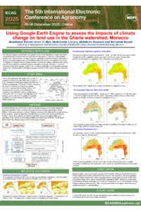
Rahimi and al.,IECAG2025.pdf
Green Synthesis of Lawsonia inermis-Mediated Silver Nanoparticles and Their Effect on Seed Germination of Chickpea
Vachellia tortilis subsp. raddiana: Pillar of deserts and model of resilience to climate change