Event submissions
Published
This submission belongs to the session S1. Environmental Assessment Methods and Management Technologies of the event The 1st International Online Conference on Environments
Published date
27 Feb, 2026
Academic Editor
'%3e%3cpath%20d='M12.6657%2010.9104C12.4185%2010.325%2012.0599%209.79327%2011.6097%209.34482C11.1609%208.89508%2010.6293%208.5365%2010.0442%208.28888C10.0389%208.28626%2010.0337%208.28495%2010.0285%208.28233C10.8446%207.69279%2011.3752%206.73249%2011.3752%205.64904C11.3752%203.8542%209.92103%202.39999%208.1262%202.39999C6.33136%202.39999%204.87715%203.8542%204.87715%205.64904C4.87715%206.73249%205.40774%207.69279%206.22393%208.28364C6.21869%208.28626%206.21345%208.28757%206.20821%208.29019C5.62129%208.5378%205.09463%208.89284%204.64265%209.34613C4.1929%209.79493%203.83432%2010.3266%203.58671%2010.9117C3.34345%2011.4845%203.21226%2012.0987%203.20023%2012.7209C3.19988%2012.7349%203.20233%2012.7488%203.20744%2012.7619C3.21255%2012.7749%203.22022%2012.7867%203.22998%2012.7968C3.23975%2012.8068%203.25142%2012.8147%203.26431%2012.8202C3.2772%2012.8256%203.29105%2012.8284%203.30504%2012.8284H4.09109C4.14874%2012.8284%204.19459%2012.7825%204.1959%2012.7262C4.2221%2011.7148%204.62823%2010.7676%205.34617%2010.0497C6.08899%209.30683%207.0755%208.89808%208.1262%208.89808C9.17689%208.89808%2010.1634%209.30683%2010.9062%2010.0497C11.6242%2010.7676%2012.0303%2011.7148%2012.0565%2012.7262C12.0578%2012.7838%2012.1037%2012.8284%2012.1613%2012.8284H12.9474C12.9613%2012.8284%2012.9752%2012.8256%2012.9881%2012.8202C13.001%2012.8147%2013.0126%2012.8068%2013.0224%2012.7968C13.0322%2012.7867%2013.0398%2012.7749%2013.0449%2012.7619C13.0501%2012.7488%2013.0525%2012.7349%2013.0522%2012.7209C13.0391%2012.0947%2012.9094%2011.4855%2012.6657%2010.9104ZM8.1262%207.9024C7.52486%207.9024%206.9589%207.6679%206.53312%207.24211C6.10733%206.81633%205.87283%206.25037%205.87283%205.64904C5.87283%205.0477%206.10733%204.48174%206.53312%204.05596C6.9589%203.63018%207.52486%203.39567%208.1262%203.39567C8.72753%203.39567%209.29349%203.63018%209.71927%204.05596C10.1451%204.48174%2010.3796%205.0477%2010.3796%205.64904C10.3796%206.25037%2010.1451%206.81633%209.71927%207.24211C9.29349%207.6679%208.72753%207.9024%208.1262%207.9024Z'%20fill='%235D1EE1'/%3e%3c/g%3e%3c/svg%3e) Milena Horvat
Milena HorvatCitation
Ezekiel Tobiloba Ogungbemi, Suleiman Abdul-Azeez Adegboyega, Environmental Impact Assessment of Quarry Impact (Land Loss and Air Quality) in Akure, Nigeria, in Proceedings of The 1st International Online Conference on Environments, 2 March–4 March 2026, MDPI: Basel, Switzerland
Share
Email
Facebook
Twitter
LinkedIn
Environmental Impact Assessment of Quarry Impact (Land Loss and Air Quality) in Akure, Nigeria
'%3e%3cpath%20d='M12.6647%2010.9104C12.4176%2010.325%2012.0589%209.7933%2011.6088%209.34485C11.16%208.89511%2010.6283%208.53653%2010.0432%208.28891C10.038%208.28629%2010.0327%208.28498%2010.0275%208.28236C10.8437%207.69282%2011.3743%206.73252%2011.3743%205.64907C11.3743%203.85423%209.92005%202.40002%208.12522%202.40002C6.33038%202.40002%204.87618%203.85423%204.87618%205.64907C4.87618%206.73252%205.40677%207.69282%206.22296%208.28367C6.21772%208.28629%206.21248%208.2876%206.20724%208.29022C5.62031%208.53783%205.09365%208.89287%204.64167%209.34616C4.19192%209.79496%203.83334%2010.3266%203.58573%2010.9117C3.34247%2011.4846%203.21128%2012.0987%203.19925%2012.721C3.1989%2012.735%203.20135%2012.7489%203.20646%2012.7619C3.21157%2012.7749%203.21924%2012.7868%203.22901%2012.7968C3.23877%2012.8068%203.25045%2012.8148%203.26334%2012.8202C3.27623%2012.8256%203.29007%2012.8284%203.30406%2012.8284H4.09012C4.14776%2012.8284%204.19362%2012.7825%204.19493%2012.7262C4.22113%2011.7148%204.62726%2010.7676%205.34519%2010.0497C6.08802%209.30686%207.07452%208.89811%208.12522%208.89811C9.17592%208.89811%2010.1624%209.30686%2010.9052%2010.0497C11.6232%2010.7676%2012.0293%2011.7148%2012.0555%2012.7262C12.0568%2012.7839%2012.1027%2012.8284%2012.1603%2012.8284H12.9464C12.9604%2012.8284%2012.9742%2012.8256%2012.9871%2012.8202C13%2012.8148%2013.0117%2012.8068%2013.0214%2012.7968C13.0312%2012.7868%2013.0389%2012.7749%2013.044%2012.7619C13.0491%2012.7489%2013.0515%2012.735%2013.0512%2012.721C13.0381%2012.0947%2012.9084%2011.4856%2012.6647%2010.9104ZM8.12522%207.90243C7.52388%207.90243%206.95792%207.66793%206.53214%207.24215C6.10636%206.81636%205.87185%206.2504%205.87185%205.64907C5.87185%205.04773%206.10636%204.48177%206.53214%204.05599C6.95792%203.63021%207.52388%203.3957%208.12522%203.3957C8.72655%203.3957%209.29252%203.63021%209.7183%204.05599C10.1441%204.48177%2010.3786%205.04773%2010.3786%205.64907C10.3786%206.2504%2010.1441%206.81636%209.7183%207.24215C9.29252%207.66793%208.72655%207.90243%208.12522%207.90243Z'%20fill='%235D1EE1'/%3e%3c/g%3e%3c/svg%3e)
Ezekiel Tobiloba Ogungbemi 1
Suleiman Abdul-Azeez Adegboyega 1
1. Remote Sensing and Geoscience Information System, School of Earth and Mineral Sciences, The Federal University of Technology Akure, Akure 340252, Ondo, Nigeria
Abstract
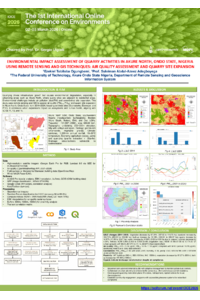
Quarrying drives infrastructure and economic growth but poses significant environmental challenges in urbanizing areas like Akure North, Ondo State, Nigeria. This study conducted an Environmental Impact Assessment (EIA) focusing on air quality and quarry site expansion by integrating remote sensing and GIS techniques. Multi-temporal satellite imagery (2014–2024) from Landsat 8/9 and Google Earth Pro was processed via GEE for LULC classification and change detection. Air quality data for PM2.5 and PM10 (2021–2024) was obtained from the OpenWeatherMap API and analyzed using Empirical Bayesian Kriging interpolation in ArcGIS Pro. LULC results revealed vegetation cover declination by 67.34%, bareland expansion by 102.73%, and water body surge by 4150% due to quarry-induced craters. The NDVI decreased from 0.064–0.408 to 0.030–0.406, and Land Surface Temperature (LST) increased from 29.23–40.72°C to 31.12–42.62°C. Air quality analysis showed that PM2.5 ranged from 4.91 to 10.34ug/m³ and PM10 from 10.24 to 17.03ug/m³, remaining consistently below their respective WHO annual thresholds (10ug/m³ and 20ug/m³, respectively). Proximity analysis using buffer zones (500m, 1000m, and 1500m) revealed significant human exposure, with 447 buildings identified within the 500m zone. Critically, this proximity indicates non-compliance with international benchmarks, such as the Code of Pollution Control (NEA Singapore) recommendation for a 3-kilometer protective buffer between quarries and residential areas. As part of the standard EIA framework, this study further recommends yearly environmental checks for environmental impact, teamwork with the government in city planning and safety zone control, quarry land restoration and recovery planning, and better community involvement and complaint systems. This study successfully integrated remote sensing and geospatial techniques to provide quantitative evidence of significant landscape transformation, vegetation loss, and thermal stress for EIA assessment for quarrying activities.
Keywords
Quarrying
EIA
Air Quality
LULC
Google Earth Engine
Change Detection
Particulate Matter (PM2.5 and PM10)
Quarry Expansion
Urbanization
Proximity Analysis
Vegetation Stress
Environmental Degradation
Poster
sciforum-155487.pdf
Mitigating Antibiotic Contamination in Aquaculture Effluents Using UVC/H₂O₂ Advanced Oxidation Process
Synergizing Intelligence-Led and Community-Oriented Policing for Environmental Sustainability: Evidence from Illegal Mining-Prone Regions in Ghana