Event submissions
Published
This submission belongs to the session S2. Environmental Impact and Risk Assessment of the event The 1st International Online Conference on Environments
Published date
27 Feb, 2026
Academic Editor
'%3e%3cpath%20d='M12.6657%2010.9104C12.4185%2010.325%2012.0599%209.79327%2011.6097%209.34482C11.1609%208.89508%2010.6293%208.5365%2010.0442%208.28888C10.0389%208.28626%2010.0337%208.28495%2010.0285%208.28233C10.8446%207.69279%2011.3752%206.73249%2011.3752%205.64904C11.3752%203.8542%209.92103%202.39999%208.1262%202.39999C6.33136%202.39999%204.87715%203.8542%204.87715%205.64904C4.87715%206.73249%205.40774%207.69279%206.22393%208.28364C6.21869%208.28626%206.21345%208.28757%206.20821%208.29019C5.62129%208.5378%205.09463%208.89284%204.64265%209.34613C4.1929%209.79493%203.83432%2010.3266%203.58671%2010.9117C3.34345%2011.4845%203.21226%2012.0987%203.20023%2012.7209C3.19988%2012.7349%203.20233%2012.7488%203.20744%2012.7619C3.21255%2012.7749%203.22022%2012.7867%203.22998%2012.7968C3.23975%2012.8068%203.25142%2012.8147%203.26431%2012.8202C3.2772%2012.8256%203.29105%2012.8284%203.30504%2012.8284H4.09109C4.14874%2012.8284%204.19459%2012.7825%204.1959%2012.7262C4.2221%2011.7148%204.62823%2010.7676%205.34617%2010.0497C6.08899%209.30683%207.0755%208.89808%208.1262%208.89808C9.17689%208.89808%2010.1634%209.30683%2010.9062%2010.0497C11.6242%2010.7676%2012.0303%2011.7148%2012.0565%2012.7262C12.0578%2012.7838%2012.1037%2012.8284%2012.1613%2012.8284H12.9474C12.9613%2012.8284%2012.9752%2012.8256%2012.9881%2012.8202C13.001%2012.8147%2013.0126%2012.8068%2013.0224%2012.7968C13.0322%2012.7867%2013.0398%2012.7749%2013.0449%2012.7619C13.0501%2012.7488%2013.0525%2012.7349%2013.0522%2012.7209C13.0391%2012.0947%2012.9094%2011.4855%2012.6657%2010.9104ZM8.1262%207.9024C7.52486%207.9024%206.9589%207.6679%206.53312%207.24211C6.10733%206.81633%205.87283%206.25037%205.87283%205.64904C5.87283%205.0477%206.10733%204.48174%206.53312%204.05596C6.9589%203.63018%207.52486%203.39567%208.1262%203.39567C8.72753%203.39567%209.29349%203.63018%209.71927%204.05596C10.1451%204.48174%2010.3796%205.0477%2010.3796%205.64904C10.3796%206.25037%2010.1451%206.81633%209.71927%207.24211C9.29349%207.6679%208.72753%207.9024%208.1262%207.9024Z'%20fill='%235D1EE1'/%3e%3c/g%3e%3c/svg%3e) Sergio Ulgiati
Sergio UlgiatiCitation
Sk. Tanjim Jaman Supto, Md. Nurjaman Ridoy, Sabbir Hossain, Spatio-Temporal Assessment of NO₂ Pollution in Bangladesh, in Proceedings of The 1st International Online Conference on Environments, 2 March–4 March 2026, MDPI: Basel, Switzerland
Share
Email
Facebook
Twitter
LinkedIn
Spatio-Temporal Assessment of NO₂ Pollution in Bangladesh

Sk. Tanjim Jaman Supto 1

Md. Nurjaman Ridoy 1

Sabbir Hossain 1
1. Department of Environmental Research, Nano Research Centre, Sylhet, 3114, Bangladesh
Abstract
Anthropogenic air pollution represents a significant threat to both environmental and human health, with nitrogen oxides (NOx) playing a substantial role in the formation of photochemical smog, acid rain, eutrophication, and respiratory diseases. In Bangladesh, NOx emissions primarily originate from combustion sources such as road transportation, power generation, and industrial activities, while natural sources include lightning, wildfires, and soil emissions. Furthermore, ammonia emissions from fertilizers and livestock exacerbate air quality issues in both urban and rural settings. Despite the acknowledgment of vehicular and industrial contributions, comprehensive and systematic assessments of NO₂ trends across the nation remain scarce. This study integrates ground-based NO₂ measurements from the Department of Environment (DoE) with atmospheric NO₂ retrieved from the Sentinel-5P TROPOMI Level-3 product via Google Earth Engine (GEE) for 2024. Spatial distribution patterns of both ground-level and atmospheric NO₂ were analyzed using ArcGIS Pro, along with seasonal and decadal trend assessments from 2015 to 2024. Results indicated pronounced spatial and temporal variability in NO₂ concentrations. The highest levels were consistently recorded over Dhaka and surrounding industrial zones, with moderate accumulation in Chattogram. Winter months (December–February) exhibited hazardous concentrations, including a peak of 212 µg/m³ in Sylhet in 2016, while monsoon periods recorded the lowest levels, such as 0.46 µg/m³ in Khulna in May 2017. Seasonal averages indicated the highest concentrations in autumn (35.13 µg/m³), followed by winter (25.67 µg/m³), with November recording the maximum monthly mean (38.94 µg/m³). Long-term analysis showed peak NO₂ levels in 2018 (34.40 µg/m³) in Chattogram, declining to 6.28 µg/m³ by 2024. These findings underscore the necessity for stricter emission regulations and targeted mitigation measures, including the implementation of NO₂-selective catalytic reduction (SCR) using NH₃ over metal oxide and zeolite catalysts. This study provides evidence-based insights to support cleaner air initiatives and sustainable environmental management strategies in Bangladesh.
Keywords
nitrogen dioxide
no₂
air pollution
bangladesh
inverse distance weighted
gis
seasonal variation
spatial distribution
emission control
environmental management
Poster
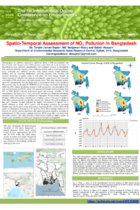
(sciforum-155075)Spatio-Temporal Assessment of NO₂ Pollution in Bangladesh.pdf
Hydrological and Economic Benefits of Sustainable Urban Drainage in an Allotment from Northeastern Portugal
FLOODING IN IBADAN NORTH EAST: GIS AS A TOOL FOR MANAGING DRAINAGE SYSTEM COLLAPSE, RIVER SYSTEM ENCROACHMENT, AND BUILDING CODE VIOLATIONS