Event submissions
Published
This submission belongs to the session S2. Environmental Impact and Risk Assessment of the event The 1st International Online Conference on Environments
Published date
27 Feb, 2026
Academic Editor
'%3e%3cpath%20d='M12.6657%2010.9104C12.4185%2010.325%2012.0599%209.79327%2011.6097%209.34482C11.1609%208.89508%2010.6293%208.5365%2010.0442%208.28888C10.0389%208.28626%2010.0337%208.28495%2010.0285%208.28233C10.8446%207.69279%2011.3752%206.73249%2011.3752%205.64904C11.3752%203.8542%209.92103%202.39999%208.1262%202.39999C6.33136%202.39999%204.87715%203.8542%204.87715%205.64904C4.87715%206.73249%205.40774%207.69279%206.22393%208.28364C6.21869%208.28626%206.21345%208.28757%206.20821%208.29019C5.62129%208.5378%205.09463%208.89284%204.64265%209.34613C4.1929%209.79493%203.83432%2010.3266%203.58671%2010.9117C3.34345%2011.4845%203.21226%2012.0987%203.20023%2012.7209C3.19988%2012.7349%203.20233%2012.7488%203.20744%2012.7619C3.21255%2012.7749%203.22022%2012.7867%203.22998%2012.7968C3.23975%2012.8068%203.25142%2012.8147%203.26431%2012.8202C3.2772%2012.8256%203.29105%2012.8284%203.30504%2012.8284H4.09109C4.14874%2012.8284%204.19459%2012.7825%204.1959%2012.7262C4.2221%2011.7148%204.62823%2010.7676%205.34617%2010.0497C6.08899%209.30683%207.0755%208.89808%208.1262%208.89808C9.17689%208.89808%2010.1634%209.30683%2010.9062%2010.0497C11.6242%2010.7676%2012.0303%2011.7148%2012.0565%2012.7262C12.0578%2012.7838%2012.1037%2012.8284%2012.1613%2012.8284H12.9474C12.9613%2012.8284%2012.9752%2012.8256%2012.9881%2012.8202C13.001%2012.8147%2013.0126%2012.8068%2013.0224%2012.7968C13.0322%2012.7867%2013.0398%2012.7749%2013.0449%2012.7619C13.0501%2012.7488%2013.0525%2012.7349%2013.0522%2012.7209C13.0391%2012.0947%2012.9094%2011.4855%2012.6657%2010.9104ZM8.1262%207.9024C7.52486%207.9024%206.9589%207.6679%206.53312%207.24211C6.10733%206.81633%205.87283%206.25037%205.87283%205.64904C5.87283%205.0477%206.10733%204.48174%206.53312%204.05596C6.9589%203.63018%207.52486%203.39567%208.1262%203.39567C8.72753%203.39567%209.29349%203.63018%209.71927%204.05596C10.1451%204.48174%2010.3796%205.0477%2010.3796%205.64904C10.3796%206.25037%2010.1451%206.81633%209.71927%207.24211C9.29349%207.6679%208.72753%207.9024%208.1262%207.9024Z'%20fill='%235D1EE1'/%3e%3c/g%3e%3c/svg%3e) Gianniantonio Petruzzelli
Gianniantonio PetruzzelliCitation
Boluwatife Joseph Atere, Olanike Kudirat Olayiwola, Dauda Rotimi Awoniran, Suleiman Abdul-Azeez Adegboyega, FLOODING IN IBADAN NORTH EAST: GIS AS A TOOL FOR MANAGING DRAINAGE SYSTEM COLLAPSE, RIVER SYSTEM ENCROACHMENT, AND BUILDING CODE VIOLATIONS, in Proceedings of The 1st International Online Conference on Environments, 2 March–4 March 2026, MDPI: Basel, Switzerland
Share
Email
Facebook
Twitter
LinkedIn
FLOODING IN IBADAN NORTH EAST: GIS AS A TOOL FOR MANAGING DRAINAGE SYSTEM COLLAPSE, RIVER SYSTEM ENCROACHMENT, AND BUILDING CODE VIOLATIONS

Boluwatife Joseph Atere 1
'%3e%3cpath%20d='M12.6647%2010.9104C12.4176%2010.325%2012.0589%209.7933%2011.6088%209.34485C11.16%208.89511%2010.6283%208.53653%2010.0432%208.28891C10.038%208.28629%2010.0327%208.28498%2010.0275%208.28236C10.8437%207.69282%2011.3743%206.73252%2011.3743%205.64907C11.3743%203.85423%209.92005%202.40002%208.12522%202.40002C6.33038%202.40002%204.87618%203.85423%204.87618%205.64907C4.87618%206.73252%205.40677%207.69282%206.22296%208.28367C6.21772%208.28629%206.21248%208.2876%206.20724%208.29022C5.62031%208.53783%205.09365%208.89287%204.64167%209.34616C4.19192%209.79496%203.83334%2010.3266%203.58573%2010.9117C3.34247%2011.4846%203.21128%2012.0987%203.19925%2012.721C3.1989%2012.735%203.20135%2012.7489%203.20646%2012.7619C3.21157%2012.7749%203.21924%2012.7868%203.22901%2012.7968C3.23877%2012.8068%203.25045%2012.8148%203.26334%2012.8202C3.27623%2012.8256%203.29007%2012.8284%203.30406%2012.8284H4.09012C4.14776%2012.8284%204.19362%2012.7825%204.19493%2012.7262C4.22113%2011.7148%204.62726%2010.7676%205.34519%2010.0497C6.08802%209.30686%207.07452%208.89811%208.12522%208.89811C9.17592%208.89811%2010.1624%209.30686%2010.9052%2010.0497C11.6232%2010.7676%2012.0293%2011.7148%2012.0555%2012.7262C12.0568%2012.7839%2012.1027%2012.8284%2012.1603%2012.8284H12.9464C12.9604%2012.8284%2012.9742%2012.8256%2012.9871%2012.8202C13%2012.8148%2013.0117%2012.8068%2013.0214%2012.7968C13.0312%2012.7868%2013.0389%2012.7749%2013.044%2012.7619C13.0491%2012.7489%2013.0515%2012.735%2013.0512%2012.721C13.0381%2012.0947%2012.9084%2011.4856%2012.6647%2010.9104ZM8.12522%207.90243C7.52388%207.90243%206.95792%207.66793%206.53214%207.24215C6.10636%206.81636%205.87185%206.2504%205.87185%205.64907C5.87185%205.04773%206.10636%204.48177%206.53214%204.05599C6.95792%203.63021%207.52388%203.3957%208.12522%203.3957C8.72655%203.3957%209.29252%203.63021%209.7183%204.05599C10.1441%204.48177%2010.3786%205.04773%2010.3786%205.64907C10.3786%206.2504%2010.1441%206.81636%209.7183%207.24215C9.29252%207.66793%208.72655%207.90243%208.12522%207.90243Z'%20fill='%235D1EE1'/%3e%3c/g%3e%3c/svg%3e)
Olanike Kudirat Olayiwola 1
Dauda Rotimi Awoniran 1
Suleiman Abdul-Azeez Adegboyega 1
1. Remote Sensing and Geoscience Information System, Federal University of Technology, Akure, Nigeria
Abstract
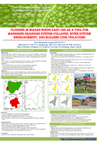
Flooding is a persistent and worsening environmental hazard in Ibadan North East Local Government Area (LGA), driven by rapid urbanization, poor drainage systems, river encroachment, and building regulation violations. The study was motivated by the need to assess these risks spatially and support effective planning and intervention. The primary objective was to identify and map flood-prone areas resulting from drainage collapse, river system encroachment, and non-compliance with urban planning regulations.
Data used include high-resolution satellite imagery, building footprints digitized in ArcGIS 10.8, and a Digital Elevation Model (DEM) used for slope and elevation analysis. GIS techniques applied were buffer analysis (to detect building encroachment within 15 meters of rivers and 30 meters of major roads), overlay analysis (to identify intersecting risk zones), and terrain modeling (to map vulnerable low-slope and low-elevation areas). Software used includes ArcGIS 10.8.2, ArcGIS Pro, QGIS, Google Earth Pro, Google Earth Engine, and Microsoft Excel. Field observations were conducted to validate spatial outputs.
Findings reveal that 23% of structures (6,053) in the LGA violate river buffer regulations, while 18% (5.090) encroach on road buffer zones, indicating widespread non-compliance. Additionally, 45% of the land area falls within low-slope zones (<3°), increasing susceptibility to runoff accumulation and surface flooding. Communities such as Beere, Oje, Idi-Arere, and Olomi, with a population of approximately 66,858, exhibited the highest concentration of overlapping risk factors. The study concludes that flooding in Ibadan North East is both a natural and structural hazard, exacerbated by institutional lapses in planning enforcement. It recommends the use of GIS for urban monitoring, enhanced drainage planning, and strict compliance with development controls to mitigate future flood risks.
Keywords
Flooding
Drainage System Collapse
Channel Encroachment
Building Regulation
Violation
Buffer Analysis
Overlay Analysis
Poster
Poster Submision.pdf
Spatio-Temporal Assessment of NO₂ Pollution in Bangladesh
Biomass-Activated Carbons in the Removal of Crystal Violet