Event submissions
Published
This submission belongs to the session S4. Digitalization, Autonomy & Airspace Management of the event The 1st International Online Conference on Aerospace
Published date
13 Apr, 2026
Academic Editor
'%3e%3cpath%20d='M12.6657%2010.9104C12.4185%2010.325%2012.0599%209.79327%2011.6097%209.34482C11.1609%208.89508%2010.6293%208.5365%2010.0442%208.28888C10.0389%208.28626%2010.0337%208.28495%2010.0285%208.28233C10.8446%207.69279%2011.3752%206.73249%2011.3752%205.64904C11.3752%203.8542%209.92103%202.39999%208.1262%202.39999C6.33136%202.39999%204.87715%203.8542%204.87715%205.64904C4.87715%206.73249%205.40774%207.69279%206.22393%208.28364C6.21869%208.28626%206.21345%208.28757%206.20821%208.29019C5.62129%208.5378%205.09463%208.89284%204.64265%209.34613C4.1929%209.79493%203.83432%2010.3266%203.58671%2010.9117C3.34345%2011.4845%203.21226%2012.0987%203.20023%2012.7209C3.19988%2012.7349%203.20233%2012.7488%203.20744%2012.7619C3.21255%2012.7749%203.22022%2012.7867%203.22998%2012.7968C3.23975%2012.8068%203.25142%2012.8147%203.26431%2012.8202C3.2772%2012.8256%203.29105%2012.8284%203.30504%2012.8284H4.09109C4.14874%2012.8284%204.19459%2012.7825%204.1959%2012.7262C4.2221%2011.7148%204.62823%2010.7676%205.34617%2010.0497C6.08899%209.30683%207.0755%208.89808%208.1262%208.89808C9.17689%208.89808%2010.1634%209.30683%2010.9062%2010.0497C11.6242%2010.7676%2012.0303%2011.7148%2012.0565%2012.7262C12.0578%2012.7838%2012.1037%2012.8284%2012.1613%2012.8284H12.9474C12.9613%2012.8284%2012.9752%2012.8256%2012.9881%2012.8202C13.001%2012.8147%2013.0126%2012.8068%2013.0224%2012.7968C13.0322%2012.7867%2013.0398%2012.7749%2013.0449%2012.7619C13.0501%2012.7488%2013.0525%2012.7349%2013.0522%2012.7209C13.0391%2012.0947%2012.9094%2011.4855%2012.6657%2010.9104ZM8.1262%207.9024C7.52486%207.9024%206.9589%207.6679%206.53312%207.24211C6.10733%206.81633%205.87283%206.25037%205.87283%205.64904C5.87283%205.0477%206.10733%204.48174%206.53312%204.05596C6.9589%203.63018%207.52486%203.39567%208.1262%203.39567C8.72753%203.39567%209.29349%203.63018%209.71927%204.05596C10.1451%204.48174%2010.3796%205.0477%2010.3796%205.64904C10.3796%206.25037%2010.1451%206.81633%209.71927%207.24211C9.29349%207.6679%208.72753%207.9024%208.1262%207.9024Z'%20fill='%235D1EE1'/%3e%3c/g%3e%3c/svg%3e) Konstantinos Kontis
Konstantinos KontisCitation
QIAN ZHAO, Carlo Emanuele Dionigi Riboldi, Ground-Based Estimation of Low-Altitude Turbulence Over Milan for Safer Airship and UAV Operations, in Proceedings of The 1st International Online Conference on Aerospace, 16 April–17 April 2026, MDPI: Basel, Switzerland
Share
Email
Facebook
Twitter
LinkedIn
Ground-Based Estimation of Low-Altitude Turbulence Over Milan for Safer Airship and UAV Operations

QIAN ZHAO 1

Carlo Emanuele Dionigi Riboldi 1
1. Department of Aerospace Science and Technology, Politecnico di Milano, Milano 20156, Italy
Abstract
Reliable characterization of atmospheric turbulence in the urban boundary layer is critical for the flight safety and structural integrity of light aerial platforms operating below 300 m. For unmanned airships, in particular, turbulence represents a well-known complication factor due to their large aerodynamic surfaces and low-speed flight regimes. An accurate understanding of near-ground conditions is essential for these vehicles, especially in Milan, where experimental activities are scheduled as part of the IPROP project. However, conventional high-resolution sensing infrastructure is often too costly or spatially sparse for real-time deployment. This study proposes a low-cost turbulence-intensity proxy, TIb, derived from standard 10-minute ground-based meteorological data. The metric is defined as TIb(t) = α|dU/dt|+βσU, capturing both impulsive shear transients and stochastic fluctuations.
The methodology was evaluated using data from two Milanese stations during April–May 2025: Lambrate (suburban) and P.zza Zavattari (dense urban core). The results show that the suburban site exhibits higher dynamic activity, with a mean TIb of 0.142 and peak excursions exceeding 0.36, indicating frequent shear-driven bursts. Conversely, the urbancore shows a smoother environment with a mean TIb of 0.097. This work maps these proxies to three operational risk categories—Nominal, Elevated Workload, and Caution—providing a practical heuristic for mission planning. The findings underscore the necessity of localized hazard mapping for Urban Air Mobility (UAM) and experimental airship operations in complex metropolitan airspaces.
Keywords
Urban Air Mobility (UAM)
Unmanned Airships
IPROP Project
Low-altitude turbulence
UAV trajectory planning
Meteorological proxy.
Poster
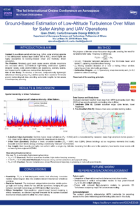
Ground Based Estimation of Low Altitude Turbulence Over Milan for Safer Airship and UAV Operations QIAN ZHAO poster.pdf
On the feasibility of a lighter-than-air platform for Martian exploration
Study on the development of a propellant tank that enables propellant refilling in microgravity (Verification of the gas–liquid separation mechanism during liquid filling through a short-term microgravity experiment)