Event submissions
Published
This submission belongs to the session S2. Urban Environments and Sustainability of the event The 1st International Online Conference on Urban Sciences
Published date
15 May, 2026
Academic Editor
'%3e%3cpath%20d='M12.6657%2010.9104C12.4185%2010.325%2012.0599%209.79327%2011.6097%209.34482C11.1609%208.89508%2010.6293%208.5365%2010.0442%208.28888C10.0389%208.28626%2010.0337%208.28495%2010.0285%208.28233C10.8446%207.69279%2011.3752%206.73249%2011.3752%205.64904C11.3752%203.8542%209.92103%202.39999%208.1262%202.39999C6.33136%202.39999%204.87715%203.8542%204.87715%205.64904C4.87715%206.73249%205.40774%207.69279%206.22393%208.28364C6.21869%208.28626%206.21345%208.28757%206.20821%208.29019C5.62129%208.5378%205.09463%208.89284%204.64265%209.34613C4.1929%209.79493%203.83432%2010.3266%203.58671%2010.9117C3.34345%2011.4845%203.21226%2012.0987%203.20023%2012.7209C3.19988%2012.7349%203.20233%2012.7488%203.20744%2012.7619C3.21255%2012.7749%203.22022%2012.7867%203.22998%2012.7968C3.23975%2012.8068%203.25142%2012.8147%203.26431%2012.8202C3.2772%2012.8256%203.29105%2012.8284%203.30504%2012.8284H4.09109C4.14874%2012.8284%204.19459%2012.7825%204.1959%2012.7262C4.2221%2011.7148%204.62823%2010.7676%205.34617%2010.0497C6.08899%209.30683%207.0755%208.89808%208.1262%208.89808C9.17689%208.89808%2010.1634%209.30683%2010.9062%2010.0497C11.6242%2010.7676%2012.0303%2011.7148%2012.0565%2012.7262C12.0578%2012.7838%2012.1037%2012.8284%2012.1613%2012.8284H12.9474C12.9613%2012.8284%2012.9752%2012.8256%2012.9881%2012.8202C13.001%2012.8147%2013.0126%2012.8068%2013.0224%2012.7968C13.0322%2012.7867%2013.0398%2012.7749%2013.0449%2012.7619C13.0501%2012.7488%2013.0525%2012.7349%2013.0522%2012.7209C13.0391%2012.0947%2012.9094%2011.4855%2012.6657%2010.9104ZM8.1262%207.9024C7.52486%207.9024%206.9589%207.6679%206.53312%207.24211C6.10733%206.81633%205.87283%206.25037%205.87283%205.64904C5.87283%205.0477%206.10733%204.48174%206.53312%204.05596C6.9589%203.63018%207.52486%203.39567%208.1262%203.39567C8.72753%203.39567%209.29349%203.63018%209.71927%204.05596C10.1451%204.48174%2010.3796%205.0477%2010.3796%205.64904C10.3796%206.25037%2010.1451%206.81633%209.71927%207.24211C9.29349%207.6679%208.72753%207.9024%208.1262%207.9024Z'%20fill='%235D1EE1'/%3e%3c/g%3e%3c/svg%3e) Eusébio Conceição
Eusébio ConceiçãoCitation
Haile Legese Zewale, Sayeh Kassaw Agegnehu, Petra Hirschler, Gerhard Navratil, Towards Climate-Resilient Affordable Housing in Addis Ababa: An Analysis of Heat Islands, in Proceedings of The 1st International Online Conference on Urban Sciences, 20 May–22 May 2026, MDPI: Basel, Switzerland
Share
Email
Facebook
Twitter
LinkedIn
Towards Climate-Resilient Affordable Housing in Addis Ababa: An Analysis of Heat Islands
'%3e%3cpath%20d='M12.6647%2010.9104C12.4176%2010.325%2012.0589%209.7933%2011.6088%209.34485C11.16%208.89511%2010.6283%208.53653%2010.0432%208.28891C10.038%208.28629%2010.0327%208.28498%2010.0275%208.28236C10.8437%207.69282%2011.3743%206.73252%2011.3743%205.64907C11.3743%203.85423%209.92005%202.40002%208.12522%202.40002C6.33038%202.40002%204.87618%203.85423%204.87618%205.64907C4.87618%206.73252%205.40677%207.69282%206.22296%208.28367C6.21772%208.28629%206.21248%208.2876%206.20724%208.29022C5.62031%208.53783%205.09365%208.89287%204.64167%209.34616C4.19192%209.79496%203.83334%2010.3266%203.58573%2010.9117C3.34247%2011.4846%203.21128%2012.0987%203.19925%2012.721C3.1989%2012.735%203.20135%2012.7489%203.20646%2012.7619C3.21157%2012.7749%203.21924%2012.7868%203.22901%2012.7968C3.23877%2012.8068%203.25045%2012.8148%203.26334%2012.8202C3.27623%2012.8256%203.29007%2012.8284%203.30406%2012.8284H4.09012C4.14776%2012.8284%204.19362%2012.7825%204.19493%2012.7262C4.22113%2011.7148%204.62726%2010.7676%205.34519%2010.0497C6.08802%209.30686%207.07452%208.89811%208.12522%208.89811C9.17592%208.89811%2010.1624%209.30686%2010.9052%2010.0497C11.6232%2010.7676%2012.0293%2011.7148%2012.0555%2012.7262C12.0568%2012.7839%2012.1027%2012.8284%2012.1603%2012.8284H12.9464C12.9604%2012.8284%2012.9742%2012.8256%2012.9871%2012.8202C13%2012.8148%2013.0117%2012.8068%2013.0214%2012.7968C13.0312%2012.7868%2013.0389%2012.7749%2013.044%2012.7619C13.0491%2012.7489%2013.0515%2012.735%2013.0512%2012.721C13.0381%2012.0947%2012.9084%2011.4856%2012.6647%2010.9104ZM8.12522%207.90243C7.52388%207.90243%206.95792%207.66793%206.53214%207.24215C6.10636%206.81636%205.87185%206.2504%205.87185%205.64907C5.87185%205.04773%206.10636%204.48177%206.53214%204.05599C6.95792%203.63021%207.52388%203.3957%208.12522%203.3957C8.72655%203.3957%209.29252%203.63021%209.7183%204.05599C10.1441%204.48177%2010.3786%205.04773%2010.3786%205.64907C10.3786%206.2504%2010.1441%206.81636%209.7183%207.24215C9.29252%207.66793%208.72655%207.90243%208.12522%207.90243Z'%20fill='%235D1EE1'/%3e%3c/g%3e%3c/svg%3e)
Haile Legese Zewale 1,2
Sayeh Kassaw Agegnehu 2
Petra Hirschler 3

Gerhard Navratil 1
1. Department of Geodesy and Geoinformation, TU Wien, 1040 Vienna, Austria
2. Institute of Land Administration, Debre Markos University, Debre Markos 269, Ethiopia
3. Research Unit of Regional Planning and Regional Development, TU Wien, 1040 Vienna, Austria
Abstract
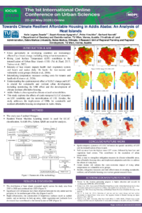
Due to rapid urbanization, cities in developing countries are increasingly affected by climate change, including rising urban temperatures. Understanding the spatiotemporal relationship between Land Use/Land Cover (LULC) change and Land Surface Temperature (LST) is crucial for sustainable, affordable housing development and for ensuring urban resilience by monitoring the Urban Heat Island (UHI) effect. This study employed remote sensing data to explore the spatiotemporal relationship between LULC and LST in Addis Ababa, Ethiopia. In addition, the study analyzed the spatial variabilities of LST values and the relationship between LST and different spectral Indices. Random Forest (RF) and geostatistical methods were employed for LULC classification and for determining the spatial variabilities of LST, respectively.
The findings highlight the increases in built-up areas between 2015 and 2020 and between 2020 and 2025. In comparison, vegetation and bare land LULC have decreased from 2015 to 2020 and from 2020 to 2025. The LULC also correlated with the LST. The highest mean LST value was found in the built-up areas. Bare land had the second-highest mean LST value after built-up areas. Vegetation land cover had the lowest mean LST value. The correlation analysis indicated a negative relationship between LST and the NDVI, SAVI, and MNDWI. In contrast, positive correlations were found between LST and the BSI and the NDBI. The results from the hotspot analysis revealed significant heat islands (hotspots) in the city center in 2015. However, heat islands have expanded rapidly to the outskirts of cities, implying gaps in the climate resilience of affordable housing units. The study's insights highlight the need for preventive measures in hotspot areas by integrating resilient design into affordable housing through actionable strategies to enhance its resilience and sustainability amid rapid urbanization and climate change. Increasing vegetation cover, using light-colored buildings, and incorporating green infrastructure have helped mitigate the rising heat effect in affordable housing areas.
Keywords
Affordable housing
LULC
LST
UHI
Hotspot analysis
Spatial autocorrelation
Poster
Towards Climate Resilient Affordable Housing in Addis Ababa An Analysis of Heat Islands (Haile Legese Zewale).pdf
Architectural Heritage and the Formation of a Layered Cityscape. The case of the Asia Minor Refugee settlements in Attica, Greece
Elucidating Urban Heat Island in an Industrial Town/s: A Case Study of Jamshedpur Urban Agglomeration