Event submissions
Published
This submission belongs to the session 5. Risk Assessment, Policy, and Environmental Justice in Chemical Safety of the event The 3rd International Online Conference on Toxics
Published date
04 Sep, 2026
Academic Editor
'%3e%3cpath%20d='M12.6657%2010.9104C12.4185%2010.325%2012.0599%209.79327%2011.6097%209.34482C11.1609%208.89508%2010.6293%208.5365%2010.0442%208.28888C10.0389%208.28626%2010.0337%208.28495%2010.0285%208.28233C10.8446%207.69279%2011.3752%206.73249%2011.3752%205.64904C11.3752%203.8542%209.92103%202.39999%208.1262%202.39999C6.33136%202.39999%204.87715%203.8542%204.87715%205.64904C4.87715%206.73249%205.40774%207.69279%206.22393%208.28364C6.21869%208.28626%206.21345%208.28757%206.20821%208.29019C5.62129%208.5378%205.09463%208.89284%204.64265%209.34613C4.1929%209.79493%203.83432%2010.3266%203.58671%2010.9117C3.34345%2011.4845%203.21226%2012.0987%203.20023%2012.7209C3.19988%2012.7349%203.20233%2012.7488%203.20744%2012.7619C3.21255%2012.7749%203.22022%2012.7867%203.22998%2012.7968C3.23975%2012.8068%203.25142%2012.8147%203.26431%2012.8202C3.2772%2012.8256%203.29105%2012.8284%203.30504%2012.8284H4.09109C4.14874%2012.8284%204.19459%2012.7825%204.1959%2012.7262C4.2221%2011.7148%204.62823%2010.7676%205.34617%2010.0497C6.08899%209.30683%207.0755%208.89808%208.1262%208.89808C9.17689%208.89808%2010.1634%209.30683%2010.9062%2010.0497C11.6242%2010.7676%2012.0303%2011.7148%2012.0565%2012.7262C12.0578%2012.7838%2012.1037%2012.8284%2012.1613%2012.8284H12.9474C12.9613%2012.8284%2012.9752%2012.8256%2012.9881%2012.8202C13.001%2012.8147%2013.0126%2012.8068%2013.0224%2012.7968C13.0322%2012.7867%2013.0398%2012.7749%2013.0449%2012.7619C13.0501%2012.7488%2013.0525%2012.7349%2013.0522%2012.7209C13.0391%2012.0947%2012.9094%2011.4855%2012.6657%2010.9104ZM8.1262%207.9024C7.52486%207.9024%206.9589%207.6679%206.53312%207.24211C6.10733%206.81633%205.87283%206.25037%205.87283%205.64904C5.87283%205.0477%206.10733%204.48174%206.53312%204.05596C6.9589%203.63018%207.52486%203.39567%208.1262%203.39567C8.72753%203.39567%209.29349%203.63018%209.71927%204.05596C10.1451%204.48174%2010.3796%205.0477%2010.3796%205.64904C10.3796%206.25037%2010.1451%206.81633%209.71927%207.24211C9.29349%207.6679%208.72753%207.9024%208.1262%207.9024Z'%20fill='%235D1EE1'/%3e%3c/g%3e%3c/svg%3e) Gunnar Toft
Gunnar ToftCitation
Héctor Ahuactzi-Cortes, Juan Carlos Gaytán-Oyarzún, Fernando Salas-Martínez, Juana Sánchez-Alarcón, Mirta Milić, Rafael Valencia-Quintana, Spatial Assessment of Environmental Vulnerability Using Multicriteria Geospatial Analysis as a Tool for Integrated Pollution Management in the Grande Tulancingo River, Mexico, in Proceedings of The 3rd International Online Conference on Toxics, 9 September–11 September 2026, MDPI: Basel, Switzerland
Share
Email
Facebook
Twitter
LinkedIn
Spatial Assessment of Environmental Vulnerability Using Multicriteria Geospatial Analysis as a Tool for Integrated Pollution Management in the Grande Tulancingo River, Mexico
'%3e%3cpath%20d='M12.6647%2010.9104C12.4176%2010.325%2012.0589%209.7933%2011.6088%209.34485C11.16%208.89511%2010.6283%208.53653%2010.0432%208.28891C10.038%208.28629%2010.0327%208.28498%2010.0275%208.28236C10.8437%207.69282%2011.3743%206.73252%2011.3743%205.64907C11.3743%203.85423%209.92005%202.40002%208.12522%202.40002C6.33038%202.40002%204.87618%203.85423%204.87618%205.64907C4.87618%206.73252%205.40677%207.69282%206.22296%208.28367C6.21772%208.28629%206.21248%208.2876%206.20724%208.29022C5.62031%208.53783%205.09365%208.89287%204.64167%209.34616C4.19192%209.79496%203.83334%2010.3266%203.58573%2010.9117C3.34247%2011.4846%203.21128%2012.0987%203.19925%2012.721C3.1989%2012.735%203.20135%2012.7489%203.20646%2012.7619C3.21157%2012.7749%203.21924%2012.7868%203.22901%2012.7968C3.23877%2012.8068%203.25045%2012.8148%203.26334%2012.8202C3.27623%2012.8256%203.29007%2012.8284%203.30406%2012.8284H4.09012C4.14776%2012.8284%204.19362%2012.7825%204.19493%2012.7262C4.22113%2011.7148%204.62726%2010.7676%205.34519%2010.0497C6.08802%209.30686%207.07452%208.89811%208.12522%208.89811C9.17592%208.89811%2010.1624%209.30686%2010.9052%2010.0497C11.6232%2010.7676%2012.0293%2011.7148%2012.0555%2012.7262C12.0568%2012.7839%2012.1027%2012.8284%2012.1603%2012.8284H12.9464C12.9604%2012.8284%2012.9742%2012.8256%2012.9871%2012.8202C13%2012.8148%2013.0117%2012.8068%2013.0214%2012.7968C13.0312%2012.7868%2013.0389%2012.7749%2013.044%2012.7619C13.0491%2012.7489%2013.0515%2012.735%2013.0512%2012.721C13.0381%2012.0947%2012.9084%2011.4856%2012.6647%2010.9104ZM8.12522%207.90243C7.52388%207.90243%206.95792%207.66793%206.53214%207.24215C6.10636%206.81636%205.87185%206.2504%205.87185%205.64907C5.87185%205.04773%206.10636%204.48177%206.53214%204.05599C6.95792%203.63021%207.52388%203.3957%208.12522%203.3957C8.72655%203.3957%209.29252%203.63021%209.7183%204.05599C10.1441%204.48177%2010.3786%205.04773%2010.3786%205.64907C10.3786%206.2504%2010.1441%206.81636%209.7183%207.24215C9.29252%207.66793%208.72655%207.90243%208.12522%207.90243Z'%20fill='%235D1EE1'/%3e%3c/g%3e%3c/svg%3e)
Héctor Ahuactzi-Cortes 1
Juan Carlos Gaytán-Oyarzún 2
Fernando Salas-Martínez 3
Juana Sánchez-Alarcón 4

Mirta Milić 5

Rafael Valencia-Quintana 4
1. Instituto de Ciencias Básicas e Ingeniería, Universidad Autónoma del Estado de Hidalgo, Pachuca, Hidalgo
2. Área Académica de Biología, Instituto de Ciencias Básicas e Ingeniería, Universidad Autónoma del Estado de Hidalgo, Pachuca, Hidalgo
3. Área Académica de Química, Instituto de Ciencias Básicas e Ingeniería, Universidad Autónoma del Estado de Hidalgo, Pachuca, Hidalgo
4. Laboratorio “Rafael Villalobos-Pietrini” de Toxicología Genómica y Química Ambiental, Facultad de Agrobiología, Universidad Autónoma de Tlaxcala, Huamantla
5. Division of Toxicology, Institute for Medical Research and Occupational Health, Zagreb
Abstract
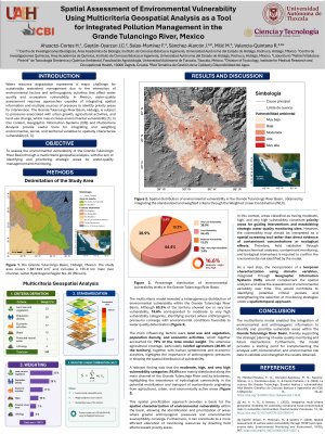
The deterioration of fluvial systems represents an environmental problem associated with urban growth, agricultural activities, and industrial development, which promote the dispersion of contaminants within hydrographic watersheds. In this context, identifying environmentally vulnerable areas is a useful tool for strengthening integrated pollution management strategies. This study aimed to assess the environmental vulnerability of the Grande Tulancingo River watershed using a multicriteria geospatial analysis that integrates biophysical and anthropogenic variables. The hydrographic delimitation of the watershed was carried out by processing an INEGI Digital Elevation Model using the SIATL simulator, allowing the definition of the drainage network, the main channel, and the catchment area. Biophysical and anthropogenic variables were integrated and processed using Geographic Information Systems (ArcGIS 10.8). Criteria selection, standardisation, reclassification, and weighting were conducted in accordance with specialised scientific literature. Subsequently, the criteria were integrated using the Weighted Overlay method to generate an environmental vulnerability map classified into five categories. The results indicated that the watershed covers an area of 1,887.623 km² and exhibits distinct hydrographic dynamics among the upper, middle, and lower zones, favouring contaminant transport toward accumulation areas. Agricultural activities cover approximately 58.2% of the watershed and were identified as the primary potential source of diffuse pollution from fertilisers and pesticides. The multicriteria analysis showed that 16.6% of the watershed exhibits moderate to very high environmental vulnerability, primarily in areas near the main channel and in zones with high hydrological connectivity. The multicriteria geospatial approach allowed the identification of priority areas for environmental monitoring and management, strengthening decision-making processes aimed at protecting aquatic ecosystems.
Keywords
environmental vulnerability
multicriteria analysis
geospatial analysis
watershed management
diffuse pollution
Poster
Cartel_Hugo AC IOCTO 2026.pdf
Clinical Masking of Insecticide Toxicity: Pharmacological Antagonism Between Flupyradifurone and Deltamethrin in Honeybees (Apis mellifera)
Heavy Metal(loid) Contamination in a Mining-Impacted Island Province in the Philippines: A Systematic Review