Event submissions
Published
This submission belongs to the session S2. Forest Biodiversity, Ecosystem Services, and Earth Observations of the event The 5th International Electronic Conference on Forests
Published date
09 Sep, 2026
Academic Editor
'%3e%3cpath%20d='M12.6657%2010.9104C12.4185%2010.325%2012.0599%209.79327%2011.6097%209.34482C11.1609%208.89508%2010.6293%208.5365%2010.0442%208.28888C10.0389%208.28626%2010.0337%208.28495%2010.0285%208.28233C10.8446%207.69279%2011.3752%206.73249%2011.3752%205.64904C11.3752%203.8542%209.92103%202.39999%208.1262%202.39999C6.33136%202.39999%204.87715%203.8542%204.87715%205.64904C4.87715%206.73249%205.40774%207.69279%206.22393%208.28364C6.21869%208.28626%206.21345%208.28757%206.20821%208.29019C5.62129%208.5378%205.09463%208.89284%204.64265%209.34613C4.1929%209.79493%203.83432%2010.3266%203.58671%2010.9117C3.34345%2011.4845%203.21226%2012.0987%203.20023%2012.7209C3.19988%2012.7349%203.20233%2012.7488%203.20744%2012.7619C3.21255%2012.7749%203.22022%2012.7867%203.22998%2012.7968C3.23975%2012.8068%203.25142%2012.8147%203.26431%2012.8202C3.2772%2012.8256%203.29105%2012.8284%203.30504%2012.8284H4.09109C4.14874%2012.8284%204.19459%2012.7825%204.1959%2012.7262C4.2221%2011.7148%204.62823%2010.7676%205.34617%2010.0497C6.08899%209.30683%207.0755%208.89808%208.1262%208.89808C9.17689%208.89808%2010.1634%209.30683%2010.9062%2010.0497C11.6242%2010.7676%2012.0303%2011.7148%2012.0565%2012.7262C12.0578%2012.7838%2012.1037%2012.8284%2012.1613%2012.8284H12.9474C12.9613%2012.8284%2012.9752%2012.8256%2012.9881%2012.8202C13.001%2012.8147%2013.0126%2012.8068%2013.0224%2012.7968C13.0322%2012.7867%2013.0398%2012.7749%2013.0449%2012.7619C13.0501%2012.7488%2013.0525%2012.7349%2013.0522%2012.7209C13.0391%2012.0947%2012.9094%2011.4855%2012.6657%2010.9104ZM8.1262%207.9024C7.52486%207.9024%206.9589%207.6679%206.53312%207.24211C6.10733%206.81633%205.87283%206.25037%205.87283%205.64904C5.87283%205.0477%206.10733%204.48174%206.53312%204.05596C6.9589%203.63018%207.52486%203.39567%208.1262%203.39567C8.72753%203.39567%209.29349%203.63018%209.71927%204.05596C10.1451%204.48174%2010.3796%205.0477%2010.3796%205.64904C10.3796%206.25037%2010.1451%206.81633%209.71927%207.24211C9.29349%207.6679%208.72753%207.9024%208.1262%207.9024Z'%20fill='%235D1EE1'/%3e%3c/g%3e%3c/svg%3e) Margarita Arianoutsou
Margarita ArianoutsouCitation
Hannah Mason, Mapping the Spatial and Temporal Dynamics of Oil Palm in Roraima, Brazil, in Proceedings of The 5th International Electronic Conference on Forests, 14 September–16 September 2026, MDPI: Basel, Switzerland
Share
Email
Facebook
Twitter
LinkedIn
Mapping the Spatial and Temporal Dynamics of Oil Palm in Roraima, Brazil
'%3e%3cpath%20d='M12.6647%2010.9104C12.4176%2010.325%2012.0589%209.7933%2011.6088%209.34485C11.16%208.89511%2010.6283%208.53653%2010.0432%208.28891C10.038%208.28629%2010.0327%208.28498%2010.0275%208.28236C10.8437%207.69282%2011.3743%206.73252%2011.3743%205.64907C11.3743%203.85423%209.92005%202.40002%208.12522%202.40002C6.33038%202.40002%204.87618%203.85423%204.87618%205.64907C4.87618%206.73252%205.40677%207.69282%206.22296%208.28367C6.21772%208.28629%206.21248%208.2876%206.20724%208.29022C5.62031%208.53783%205.09365%208.89287%204.64167%209.34616C4.19192%209.79496%203.83334%2010.3266%203.58573%2010.9117C3.34247%2011.4846%203.21128%2012.0987%203.19925%2012.721C3.1989%2012.735%203.20135%2012.7489%203.20646%2012.7619C3.21157%2012.7749%203.21924%2012.7868%203.22901%2012.7968C3.23877%2012.8068%203.25045%2012.8148%203.26334%2012.8202C3.27623%2012.8256%203.29007%2012.8284%203.30406%2012.8284H4.09012C4.14776%2012.8284%204.19362%2012.7825%204.19493%2012.7262C4.22113%2011.7148%204.62726%2010.7676%205.34519%2010.0497C6.08802%209.30686%207.07452%208.89811%208.12522%208.89811C9.17592%208.89811%2010.1624%209.30686%2010.9052%2010.0497C11.6232%2010.7676%2012.0293%2011.7148%2012.0555%2012.7262C12.0568%2012.7839%2012.1027%2012.8284%2012.1603%2012.8284H12.9464C12.9604%2012.8284%2012.9742%2012.8256%2012.9871%2012.8202C13%2012.8148%2013.0117%2012.8068%2013.0214%2012.7968C13.0312%2012.7868%2013.0389%2012.7749%2013.044%2012.7619C13.0491%2012.7489%2013.0515%2012.735%2013.0512%2012.721C13.0381%2012.0947%2012.9084%2011.4856%2012.6647%2010.9104ZM8.12522%207.90243C7.52388%207.90243%206.95792%207.66793%206.53214%207.24215C6.10636%206.81636%205.87185%206.2504%205.87185%205.64907C5.87185%205.04773%206.10636%204.48177%206.53214%204.05599C6.95792%203.63021%207.52388%203.3957%208.12522%203.3957C8.72655%203.3957%209.29252%203.63021%209.7183%204.05599C10.1441%204.48177%2010.3786%205.04773%2010.3786%205.64907C10.3786%206.2504%2010.1441%206.81636%209.7183%207.24215C9.29252%207.66793%208.72655%207.90243%208.12522%207.90243Z'%20fill='%235D1EE1'/%3e%3c/g%3e%3c/svg%3e)
Hannah Mason 1
1. Department of Geography and Planning, The University of Sheffield, Sheffield, S10 2TN, United Kingdom
Abstract
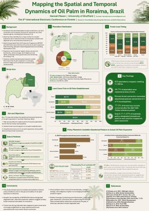
Oil palm expansion in Southeast Asia and other tropical regions is associated with severe environmental degradation, social conflict, and illegal activity, including biodiversity loss, high CO₂ emissions, ecosystem collapse, Indigenous conflicts, and illicit forest fires. As Indonesia and Malaysia — the world’s leading oil palm producers — approach production limits, other tropical regions are emerging as potential sites for future expansion. Brazil has been identified as a key country for large-scale, sustainable oil palm expansion, primarily due to its extensive areas of abandoned pasture designated as ‘available’ for development. Since the introduction of the Sustainable Palm Oil Production Program (SPOPP), production in Brazil has accelerated, raising debate over whether national sustainability policies are effectively steering expansion away from primary forests and toward degraded lands, particularly beyond the main oil palm-producing hub of Pará. This study investigates the spatial and temporal dynamics of oil palm expansion in the Brazilian state of Roraima, focusing on the municipalities of Rorainópolis, São Luiz, São João da Baliza, and Caroebe. Remote sensing (RS) and geographic information systems (GIS) were used to assess the extent of oil palm plantations, the timeframe of associated deforestation, and land use/land cover (LULC) prior to oil palm establishment. A clear preference for primary forest conversion was found in all municipalities except Rorainópolis, despite widespread availability of policy-designated pastureland. Caroebe had the highest rate of primary forest conversion, with São João da Baliza also showing significant deforestation linked to oil palm expansion. Over 98% of mapped plantations were located within the Global Forest Watch Emerging Hotspots dataset. Most mapped forest loss associated with current oil palm plantations occurred after the introduction of SPOPP in 2010, peaking between 2012 and 2016. The findings suggest that the current policy framework has not consistently prevented primary forest conversion associated with oil palm expansion in Roraima.
Keywords
oil palm expansion
deforestation
remote sensing
GIS
Roraima
Brazil
land use/land cover
primary forest conversion
sustainable palm oil
Amazon
Poster
Hannah_Mason_Mapping_the_Spatial_and_Temporal_Dynamics_of_Oil_Palm_in_Roraima_Brazil_MDPI.pdf
Black locust post-mining restoration plantations reduce and modulate noise propagation at a mining area in Greece
Diversity of Slime Moulds (Eumycetozoa) in Three Forest Nature Reserves of the Knyszyn Forest, Poland