Event submissions
Published
This submission belongs to the session S4. Forest Inventory, Modeling and Remote Sensing of the event The 5th International Electronic Conference on Forests
Published date
09 Sep, 2026
Academic Editor
'%3e%3cpath%20d='M12.6657%2010.9104C12.4185%2010.325%2012.0599%209.79327%2011.6097%209.34482C11.1609%208.89508%2010.6293%208.5365%2010.0442%208.28888C10.0389%208.28626%2010.0337%208.28495%2010.0285%208.28233C10.8446%207.69279%2011.3752%206.73249%2011.3752%205.64904C11.3752%203.8542%209.92103%202.39999%208.1262%202.39999C6.33136%202.39999%204.87715%203.8542%204.87715%205.64904C4.87715%206.73249%205.40774%207.69279%206.22393%208.28364C6.21869%208.28626%206.21345%208.28757%206.20821%208.29019C5.62129%208.5378%205.09463%208.89284%204.64265%209.34613C4.1929%209.79493%203.83432%2010.3266%203.58671%2010.9117C3.34345%2011.4845%203.21226%2012.0987%203.20023%2012.7209C3.19988%2012.7349%203.20233%2012.7488%203.20744%2012.7619C3.21255%2012.7749%203.22022%2012.7867%203.22998%2012.7968C3.23975%2012.8068%203.25142%2012.8147%203.26431%2012.8202C3.2772%2012.8256%203.29105%2012.8284%203.30504%2012.8284H4.09109C4.14874%2012.8284%204.19459%2012.7825%204.1959%2012.7262C4.2221%2011.7148%204.62823%2010.7676%205.34617%2010.0497C6.08899%209.30683%207.0755%208.89808%208.1262%208.89808C9.17689%208.89808%2010.1634%209.30683%2010.9062%2010.0497C11.6242%2010.7676%2012.0303%2011.7148%2012.0565%2012.7262C12.0578%2012.7838%2012.1037%2012.8284%2012.1613%2012.8284H12.9474C12.9613%2012.8284%2012.9752%2012.8256%2012.9881%2012.8202C13.001%2012.8147%2013.0126%2012.8068%2013.0224%2012.7968C13.0322%2012.7867%2013.0398%2012.7749%2013.0449%2012.7619C13.0501%2012.7488%2013.0525%2012.7349%2013.0522%2012.7209C13.0391%2012.0947%2012.9094%2011.4855%2012.6657%2010.9104ZM8.1262%207.9024C7.52486%207.9024%206.9589%207.6679%206.53312%207.24211C6.10733%206.81633%205.87283%206.25037%205.87283%205.64904C5.87283%205.0477%206.10733%204.48174%206.53312%204.05596C6.9589%203.63018%207.52486%203.39567%208.1262%203.39567C8.72753%203.39567%209.29349%203.63018%209.71927%204.05596C10.1451%204.48174%2010.3796%205.0477%2010.3796%205.64904C10.3796%206.25037%2010.1451%206.81633%209.71927%207.24211C9.29349%207.6679%208.72753%207.9024%208.1262%207.9024Z'%20fill='%235D1EE1'/%3e%3c/g%3e%3c/svg%3e) Krzysztof Stereńczak
Krzysztof StereńczakCitation
Victor Allory, Colette Gelas, Louis de Vitry, Adrien Salem-Sermanet, Optimizing aboveground biomass estimation in novel restoration systems through remote sensing and field data fusion, in Proceedings of The 5th International Electronic Conference on Forests, 14 September–16 September 2026, MDPI: Basel, Switzerland
Share
Email
Facebook
Twitter
LinkedIn
Optimizing aboveground biomass estimation in novel restoration systems through remote sensing and field data fusion
'%3e%3cpath%20d='M12.6647%2010.9104C12.4176%2010.325%2012.0589%209.7933%2011.6088%209.34485C11.16%208.89511%2010.6283%208.53653%2010.0432%208.28891C10.038%208.28629%2010.0327%208.28498%2010.0275%208.28236C10.8437%207.69282%2011.3743%206.73252%2011.3743%205.64907C11.3743%203.85423%209.92005%202.40002%208.12522%202.40002C6.33038%202.40002%204.87618%203.85423%204.87618%205.64907C4.87618%206.73252%205.40677%207.69282%206.22296%208.28367C6.21772%208.28629%206.21248%208.2876%206.20724%208.29022C5.62031%208.53783%205.09365%208.89287%204.64167%209.34616C4.19192%209.79496%203.83334%2010.3266%203.58573%2010.9117C3.34247%2011.4846%203.21128%2012.0987%203.19925%2012.721C3.1989%2012.735%203.20135%2012.7489%203.20646%2012.7619C3.21157%2012.7749%203.21924%2012.7868%203.22901%2012.7968C3.23877%2012.8068%203.25045%2012.8148%203.26334%2012.8202C3.27623%2012.8256%203.29007%2012.8284%203.30406%2012.8284H4.09012C4.14776%2012.8284%204.19362%2012.7825%204.19493%2012.7262C4.22113%2011.7148%204.62726%2010.7676%205.34519%2010.0497C6.08802%209.30686%207.07452%208.89811%208.12522%208.89811C9.17592%208.89811%2010.1624%209.30686%2010.9052%2010.0497C11.6232%2010.7676%2012.0293%2011.7148%2012.0555%2012.7262C12.0568%2012.7839%2012.1027%2012.8284%2012.1603%2012.8284H12.9464C12.9604%2012.8284%2012.9742%2012.8256%2012.9871%2012.8202C13%2012.8148%2013.0117%2012.8068%2013.0214%2012.7968C13.0312%2012.7868%2013.0389%2012.7749%2013.044%2012.7619C13.0491%2012.7489%2013.0515%2012.735%2013.0512%2012.721C13.0381%2012.0947%2012.9084%2011.4856%2012.6647%2010.9104ZM8.12522%207.90243C7.52388%207.90243%206.95792%207.66793%206.53214%207.24215C6.10636%206.81636%205.87185%206.2504%205.87185%205.64907C5.87185%205.04773%206.10636%204.48177%206.53214%204.05599C6.95792%203.63021%207.52388%203.3957%208.12522%203.3957C8.72655%203.3957%209.29252%203.63021%209.7183%204.05599C10.1441%204.48177%2010.3786%205.04773%2010.3786%205.64907C10.3786%206.2504%2010.1441%206.81636%209.7183%207.24215C9.29252%207.66793%208.72655%207.90243%208.12522%207.90243Z'%20fill='%235D1EE1'/%3e%3c/g%3e%3c/svg%3e)
Victor Allory 1
Colette Gelas 1
Louis de Vitry 1
Adrien Salem-Sermanet 1
1. Kanop (RAIL SAS), 3, rue Joliot Curie, Gif-sur-Yvette, 91190, France
Abstract
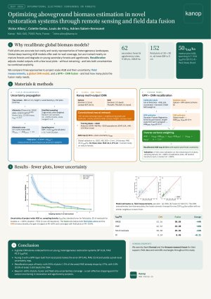
Accurate assessment of aboveground biomass (AGB) stocks is critical for monitoring nature-based projects, yet field measurements and remote sensing each have limitations when applied independently. Field measurements are accurate but costly and often lack spatial representativeness, while global deep learning models offer broad coverage but can perform poorly in heterogeneous and novel restoration systems.
We propose a fusion model method that merges AGB estimates from a global Convolutional Neural Network (CNN) model with a field-driven layer generated by Gaussian Process Regression (GPR). The global CNN, trained on airborne and spaceborne LiDAR, ingests optical (Sentinel-2 at 10 m; Landsat-8/9 at 30 m) and SAR (Sentinel-1 and PALSAR-2) data to directly predict AGB. Field plots play a dual role: beyond validating the CNN, 6-fold cross-validation splits them into a calibration subset used as labels to train the GPR (with coordinates and Sentinel-2 spectral data as inputs for spatial generalization), and a validation subset evaluating the fused GPR-CNN map. The CNN and GPR estimates are combined through inverse-variance weighting, producing a recalibrated AGB map with explicit pixel-level uncertainty. We evaluated this approach across 62 secondary forest and agroforestry sites of varying ages (5–48 years) covering 268.8 ha in Pará State, Brazil, using 152 field measurement plots.
The global CNN model performed poorly on these heterogeneous sites (R² = 0.24, MAE = 42.32 tDM/ha, RMSE = 53.16 tDM/ha), reflecting training data dominated by mature forests. The fusion model substantially improved accuracy (R² = 0.45, MAE = 23.38 tDM/ha, RMSE = 30.03 tDM/ha). Even with only 25% of available field measurements (approximately 2% of total area), MAE decreased by 17% relative to the CNN model alone.
This approach offers a scalable, cost-effective solution for carbon stock monitoring in restoration and agroforestry projects.
Keywords
AGB estimation
model fusion
Gaussian Process Regression
CNN
uncertainty
agroforestry
remote sensing
Poster
IECF 2026 Conference Poster.pdf
Assessment of long-term urban vegetation quantity versus quality by decoding green vigor, atmospheric resilience, chlorophyll, and senescence analysis applying multi-spectral remote sensing data fusion
Predicting tree diameter from height with regard to the tree age for Scots pine in Poland