Event submissions
Published
This submission belongs to the session S4. Forest Inventory, Modeling and Remote Sensing of the event The 5th International Electronic Conference on Forests
Published date
09 Sep, 2026
Academic Editor
'%3e%3cpath%20d='M12.6657%2010.9104C12.4185%2010.325%2012.0599%209.79327%2011.6097%209.34482C11.1609%208.89508%2010.6293%208.5365%2010.0442%208.28888C10.0389%208.28626%2010.0337%208.28495%2010.0285%208.28233C10.8446%207.69279%2011.3752%206.73249%2011.3752%205.64904C11.3752%203.8542%209.92103%202.39999%208.1262%202.39999C6.33136%202.39999%204.87715%203.8542%204.87715%205.64904C4.87715%206.73249%205.40774%207.69279%206.22393%208.28364C6.21869%208.28626%206.21345%208.28757%206.20821%208.29019C5.62129%208.5378%205.09463%208.89284%204.64265%209.34613C4.1929%209.79493%203.83432%2010.3266%203.58671%2010.9117C3.34345%2011.4845%203.21226%2012.0987%203.20023%2012.7209C3.19988%2012.7349%203.20233%2012.7488%203.20744%2012.7619C3.21255%2012.7749%203.22022%2012.7867%203.22998%2012.7968C3.23975%2012.8068%203.25142%2012.8147%203.26431%2012.8202C3.2772%2012.8256%203.29105%2012.8284%203.30504%2012.8284H4.09109C4.14874%2012.8284%204.19459%2012.7825%204.1959%2012.7262C4.2221%2011.7148%204.62823%2010.7676%205.34617%2010.0497C6.08899%209.30683%207.0755%208.89808%208.1262%208.89808C9.17689%208.89808%2010.1634%209.30683%2010.9062%2010.0497C11.6242%2010.7676%2012.0303%2011.7148%2012.0565%2012.7262C12.0578%2012.7838%2012.1037%2012.8284%2012.1613%2012.8284H12.9474C12.9613%2012.8284%2012.9752%2012.8256%2012.9881%2012.8202C13.001%2012.8147%2013.0126%2012.8068%2013.0224%2012.7968C13.0322%2012.7867%2013.0398%2012.7749%2013.0449%2012.7619C13.0501%2012.7488%2013.0525%2012.7349%2013.0522%2012.7209C13.0391%2012.0947%2012.9094%2011.4855%2012.6657%2010.9104ZM8.1262%207.9024C7.52486%207.9024%206.9589%207.6679%206.53312%207.24211C6.10733%206.81633%205.87283%206.25037%205.87283%205.64904C5.87283%205.0477%206.10733%204.48174%206.53312%204.05596C6.9589%203.63018%207.52486%203.39567%208.1262%203.39567C8.72753%203.39567%209.29349%203.63018%209.71927%204.05596C10.1451%204.48174%2010.3796%205.0477%2010.3796%205.64904C10.3796%206.25037%2010.1451%206.81633%209.71927%207.24211C9.29349%207.6679%208.72753%207.9024%208.1262%207.9024Z'%20fill='%235D1EE1'/%3e%3c/g%3e%3c/svg%3e) Krzysztof Stereńczak
Krzysztof StereńczakCitation
Ekaterina Sergeevna Podolskaia, Anna Nikolaevna Sinitsina, Dataset of winter roads of Krasnoyarsk Krai, Russia for the forestry infrastructural research, in Proceedings of The 5th International Electronic Conference on Forests, 14 September–16 September 2026, MDPI: Basel, Switzerland
Share
Email
Facebook
Twitter
LinkedIn
Dataset of winter roads of Krasnoyarsk Krai, Russia for the forestry infrastructural research
'%3e%3cpath%20d='M12.6647%2010.9104C12.4176%2010.325%2012.0589%209.7933%2011.6088%209.34485C11.16%208.89511%2010.6283%208.53653%2010.0432%208.28891C10.038%208.28629%2010.0327%208.28498%2010.0275%208.28236C10.8437%207.69282%2011.3743%206.73252%2011.3743%205.64907C11.3743%203.85423%209.92005%202.40002%208.12522%202.40002C6.33038%202.40002%204.87618%203.85423%204.87618%205.64907C4.87618%206.73252%205.40677%207.69282%206.22296%208.28367C6.21772%208.28629%206.21248%208.2876%206.20724%208.29022C5.62031%208.53783%205.09365%208.89287%204.64167%209.34616C4.19192%209.79496%203.83334%2010.3266%203.58573%2010.9117C3.34247%2011.4846%203.21128%2012.0987%203.19925%2012.721C3.1989%2012.735%203.20135%2012.7489%203.20646%2012.7619C3.21157%2012.7749%203.21924%2012.7868%203.22901%2012.7968C3.23877%2012.8068%203.25045%2012.8148%203.26334%2012.8202C3.27623%2012.8256%203.29007%2012.8284%203.30406%2012.8284H4.09012C4.14776%2012.8284%204.19362%2012.7825%204.19493%2012.7262C4.22113%2011.7148%204.62726%2010.7676%205.34519%2010.0497C6.08802%209.30686%207.07452%208.89811%208.12522%208.89811C9.17592%208.89811%2010.1624%209.30686%2010.9052%2010.0497C11.6232%2010.7676%2012.0293%2011.7148%2012.0555%2012.7262C12.0568%2012.7839%2012.1027%2012.8284%2012.1603%2012.8284H12.9464C12.9604%2012.8284%2012.9742%2012.8256%2012.9871%2012.8202C13%2012.8148%2013.0117%2012.8068%2013.0214%2012.7968C13.0312%2012.7868%2013.0389%2012.7749%2013.044%2012.7619C13.0491%2012.7489%2013.0515%2012.735%2013.0512%2012.721C13.0381%2012.0947%2012.9084%2011.4856%2012.6647%2010.9104ZM8.12522%207.90243C7.52388%207.90243%206.95792%207.66793%206.53214%207.24215C6.10636%206.81636%205.87185%206.2504%205.87185%205.64907C5.87185%205.04773%206.10636%204.48177%206.53214%204.05599C6.95792%203.63021%207.52388%203.3957%208.12522%203.3957C8.72655%203.3957%209.29252%203.63021%209.7183%204.05599C10.1441%204.48177%2010.3786%205.04773%2010.3786%205.64907C10.3786%206.2504%2010.1441%206.81636%209.7183%207.24215C9.29252%207.66793%208.72655%207.90243%208.12522%207.90243Z'%20fill='%235D1EE1'/%3e%3c/g%3e%3c/svg%3e)
Ekaterina Sergeevna Podolskaia 1,2
Anna Nikolaevna Sinitsina 2
1. Laboratory of Forest Ecosystem Monitoring, Isaev Centre for Forest Ecology and Productivity of the Russian Academy of Sciences (CEPF RAS), Moscow 117997, Russian Federation
2. Faculty of Geography and Geoinformation technologies, Moscow campus, HSE University , 20 Myasnitskaya Ulitsa, Moscow, 101000, Russia
Abstract
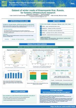
Winter roads and ice crossings play a critical role in providing seasonal access to remote forest areas, timber harvesting sites, and forestry industry facilities in Krasnoyarsk Krai, Russia. In forest regions with sparse permanent road infrastructure, winter roads often determine the feasibility of timber extraction, forest management operations, and infrastructure maintenance. However, data on winter roads are fragmented across a variety of spatial layers, official reports, and archived web pages, which limits their use in forest transport planning and accessibility assessment. This study presents an original workflow for collecting, restoring, and systematizing data on winter roads for the 2019-2026 seasons. Data were gathered from regional road authority reports, archived web pages, OpenStreetMap, road network datasets, environmental sources, and forestry-related spatial layers. The workflow included extraction of road status records, opening and closing dates, geometry harmonization, name normalization, duplicate removal, municipal attribution, spatial joins, and integration with forest-related indicators. Created geodatabase includes 1,758 winter road segments, 60 municipalities, 1,253 hexagonal cells, 55 hexagonal groups, and 73 forestry industry sites within the region. It enables assessment of winter road availability, seasonal activity, access to the forestry facilities, and validation of opening and closing date predictions. A validation subset of 40 comparisons with official records showed an average prediction error of 6.3 days for road opening and 9.0 days for road closing. The study demonstrates that winter road data for forest regions should include not only road geometry, but also evidence of seasonal operation. The developed database is a subject of updates, would be of help for the GIS analysis, machine learning modelling, forest transport planning, forestry accessibility assessment, and identification of areas with limited seasonal access.
Keywords
Dataset
seasonality
winter roads
infrastructure
forestry complex
Poster
IECF2026_Podolskaia_Sinitsina_poster.pdf
A Comparison of Some Machine Learning Classifiers Applied in Three Silvopastoral Systems of Greece.
Season-driven growth responses in juvenile Eucalyptus across different species and planting densities.