Event submissions
Published
This submission belongs to the session S4. Forest Inventory, Modeling and Remote Sensing of the event The 5th International Electronic Conference on Forests
Published date
09 Sep, 2026
Academic Editor
'%3e%3cpath%20d='M12.6657%2010.9104C12.4185%2010.325%2012.0599%209.79327%2011.6097%209.34482C11.1609%208.89508%2010.6293%208.5365%2010.0442%208.28888C10.0389%208.28626%2010.0337%208.28495%2010.0285%208.28233C10.8446%207.69279%2011.3752%206.73249%2011.3752%205.64904C11.3752%203.8542%209.92103%202.39999%208.1262%202.39999C6.33136%202.39999%204.87715%203.8542%204.87715%205.64904C4.87715%206.73249%205.40774%207.69279%206.22393%208.28364C6.21869%208.28626%206.21345%208.28757%206.20821%208.29019C5.62129%208.5378%205.09463%208.89284%204.64265%209.34613C4.1929%209.79493%203.83432%2010.3266%203.58671%2010.9117C3.34345%2011.4845%203.21226%2012.0987%203.20023%2012.7209C3.19988%2012.7349%203.20233%2012.7488%203.20744%2012.7619C3.21255%2012.7749%203.22022%2012.7867%203.22998%2012.7968C3.23975%2012.8068%203.25142%2012.8147%203.26431%2012.8202C3.2772%2012.8256%203.29105%2012.8284%203.30504%2012.8284H4.09109C4.14874%2012.8284%204.19459%2012.7825%204.1959%2012.7262C4.2221%2011.7148%204.62823%2010.7676%205.34617%2010.0497C6.08899%209.30683%207.0755%208.89808%208.1262%208.89808C9.17689%208.89808%2010.1634%209.30683%2010.9062%2010.0497C11.6242%2010.7676%2012.0303%2011.7148%2012.0565%2012.7262C12.0578%2012.7838%2012.1037%2012.8284%2012.1613%2012.8284H12.9474C12.9613%2012.8284%2012.9752%2012.8256%2012.9881%2012.8202C13.001%2012.8147%2013.0126%2012.8068%2013.0224%2012.7968C13.0322%2012.7867%2013.0398%2012.7749%2013.0449%2012.7619C13.0501%2012.7488%2013.0525%2012.7349%2013.0522%2012.7209C13.0391%2012.0947%2012.9094%2011.4855%2012.6657%2010.9104ZM8.1262%207.9024C7.52486%207.9024%206.9589%207.6679%206.53312%207.24211C6.10733%206.81633%205.87283%206.25037%205.87283%205.64904C5.87283%205.0477%206.10733%204.48174%206.53312%204.05596C6.9589%203.63018%207.52486%203.39567%208.1262%203.39567C8.72753%203.39567%209.29349%203.63018%209.71927%204.05596C10.1451%204.48174%2010.3796%205.0477%2010.3796%205.64904C10.3796%206.25037%2010.1451%206.81633%209.71927%207.24211C9.29349%207.6679%208.72753%207.9024%208.1262%207.9024Z'%20fill='%235D1EE1'/%3e%3c/g%3e%3c/svg%3e) Krzysztof Stereńczak
Krzysztof StereńczakCitation
Vladimir Visacki, Lazar Pavlovic, Olivera Kalozi, Lazar Kesic, Lazar Tursijan, Lazar Jeftic, Sasa Orlovic, Rule-Based Multi-Sensor Classification of Agroforestry Windbreak Systems Using Sentinel-1, Sentinel-2 and Land Cover Data, in Proceedings of The 5th International Electronic Conference on Forests, 14 September–16 September 2026, MDPI: Basel, Switzerland
Share
Email
Facebook
Twitter
LinkedIn
Rule-Based Multi-Sensor Classification of Agroforestry Windbreak Systems Using Sentinel-1, Sentinel-2 and Land Cover Data

Vladimir Visacki 1

Lazar Pavlovic 2

Olivera Kalozi 2
'%3e%3cpath%20d='M12.6647%2010.9104C12.4176%2010.325%2012.0589%209.7933%2011.6088%209.34485C11.16%208.89511%2010.6283%208.53653%2010.0432%208.28891C10.038%208.28629%2010.0327%208.28498%2010.0275%208.28236C10.8437%207.69282%2011.3743%206.73252%2011.3743%205.64907C11.3743%203.85423%209.92005%202.40002%208.12522%202.40002C6.33038%202.40002%204.87618%203.85423%204.87618%205.64907C4.87618%206.73252%205.40677%207.69282%206.22296%208.28367C6.21772%208.28629%206.21248%208.2876%206.20724%208.29022C5.62031%208.53783%205.09365%208.89287%204.64167%209.34616C4.19192%209.79496%203.83334%2010.3266%203.58573%2010.9117C3.34247%2011.4846%203.21128%2012.0987%203.19925%2012.721C3.1989%2012.735%203.20135%2012.7489%203.20646%2012.7619C3.21157%2012.7749%203.21924%2012.7868%203.22901%2012.7968C3.23877%2012.8068%203.25045%2012.8148%203.26334%2012.8202C3.27623%2012.8256%203.29007%2012.8284%203.30406%2012.8284H4.09012C4.14776%2012.8284%204.19362%2012.7825%204.19493%2012.7262C4.22113%2011.7148%204.62726%2010.7676%205.34519%2010.0497C6.08802%209.30686%207.07452%208.89811%208.12522%208.89811C9.17592%208.89811%2010.1624%209.30686%2010.9052%2010.0497C11.6232%2010.7676%2012.0293%2011.7148%2012.0555%2012.7262C12.0568%2012.7839%2012.1027%2012.8284%2012.1603%2012.8284H12.9464C12.9604%2012.8284%2012.9742%2012.8256%2012.9871%2012.8202C13%2012.8148%2013.0117%2012.8068%2013.0214%2012.7968C13.0312%2012.7868%2013.0389%2012.7749%2013.044%2012.7619C13.0491%2012.7489%2013.0515%2012.735%2013.0512%2012.721C13.0381%2012.0947%2012.9084%2011.4856%2012.6647%2010.9104ZM8.12522%207.90243C7.52388%207.90243%206.95792%207.66793%206.53214%207.24215C6.10636%206.81636%205.87185%206.2504%205.87185%205.64907C5.87185%205.04773%206.10636%204.48177%206.53214%204.05599C6.95792%203.63021%207.52388%203.3957%208.12522%203.3957C8.72655%203.3957%209.29252%203.63021%209.7183%204.05599C10.1441%204.48177%2010.3786%205.04773%2010.3786%205.64907C10.3786%206.2504%2010.1441%206.81636%209.7183%207.24215C9.29252%207.66793%208.72655%207.90243%208.12522%207.90243Z'%20fill='%235D1EE1'/%3e%3c/g%3e%3c/svg%3e)
Lazar Kesic 1
Lazar Tursijan 2
Lazar Jeftic 1
Sasa Orlovic 1
1. Institute of Lowland Forestry and Environment, University of Novi Sad, Novi Sad, Serbia
2. Faculty of Agriculture, University of Novi Sad, Novi Sad, Serbia
Abstract
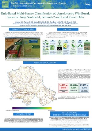
Woody linear vegetation elements that may function as agroforestry windbreaks are expected to play an important role in the intensively cultivated lowlands of Vojvodina (Serbia), contributing to wind erosion control, microclimate regulation, biodiversity enhancement and overall agroecosystem resilience. Despite their ecological and agronomic importance, their regional-scale spatial distribution remains insufficiently quantified. This study presents a rule-based remote sensing workflow for automated detection of potential windbreak elements across Vojvodina at 10 m spatial resolution.
Sentinel-2 surface reflectance imagery (June–August 2024) was used to derive NDVI as an indicator of vegetation vigor, while Sentinel-1 SAR VH backscatter provided sensitivity to vertical woody structure. A combined NDVI–VH threshold approach was implemented to identify spectrally and structurally woody vegetation. ESA WorldCover 10 m land use data were incorporated to constrain detection to non-cropland pixels located adjacent to agricultural fields, while explicitly excluding forest, built-up and water classes. Additional connected-pixel filtering was applied to remove large continuous forest patches, retaining smaller and fragmented woody elements characteristic of windbreak systems. The classification therefore integrates spectral, structural and contextual spatial criteria rather than relying on single-source imagery.
Applied to the entire territory of Vojvodina (~5.31 million ha), the workflow identified approximately 25,146 ha of potential agroforestry windbreak elements, representing 0.47% of the provincial area. The resulting raster mask enables municipality-level aggregation, spatial prioritization and further assessment of ecosystem service provision.
However, the approach represents a rapid screening methodology and is subject to limitations, including potential misclassification within ESA WorldCover land use categories, spectral confusion between shrubland and young forest stands, and the absence of field-based validation. Integration with ground surveys and higher-resolution imagery would improve classification accuracy and support refinement of detection thresholds.
The results demonstrate that freely available Copernicus datasets allow scalable, operational mapping of agroforestry systems in highly intensified agricultural landscapes.
Keywords
Agroforestry systems
Windbreaks
Multi-sensor remote sensing
Rule-based classification
Sentinel-1
Sentinel-2
ESA WorldCover
Poster
Visacki V Windbeaks in Agroforestry clasification F.pdf
Multi-Sensor Mapping of Forest Type Transitions in Central Angola: A Cloud-Based Random Forest Assessment (2015–2025)
Remote sensing-based quantification of windbreak condition and associated crop responses in agroforestry systems: evidence from Vojvodina, Serbia