Event submissions
Published
This submission belongs to the session S4. Weather and Climate Forecasting of the event The 1st International Online Conference on Forecasting
Published date
16 Sep, 2026
Academic Editor
'%3e%3cpath%20d='M12.6657%2010.9104C12.4185%2010.325%2012.0599%209.79327%2011.6097%209.34482C11.1609%208.89508%2010.6293%208.5365%2010.0442%208.28888C10.0389%208.28626%2010.0337%208.28495%2010.0285%208.28233C10.8446%207.69279%2011.3752%206.73249%2011.3752%205.64904C11.3752%203.8542%209.92103%202.39999%208.1262%202.39999C6.33136%202.39999%204.87715%203.8542%204.87715%205.64904C4.87715%206.73249%205.40774%207.69279%206.22393%208.28364C6.21869%208.28626%206.21345%208.28757%206.20821%208.29019C5.62129%208.5378%205.09463%208.89284%204.64265%209.34613C4.1929%209.79493%203.83432%2010.3266%203.58671%2010.9117C3.34345%2011.4845%203.21226%2012.0987%203.20023%2012.7209C3.19988%2012.7349%203.20233%2012.7488%203.20744%2012.7619C3.21255%2012.7749%203.22022%2012.7867%203.22998%2012.7968C3.23975%2012.8068%203.25142%2012.8147%203.26431%2012.8202C3.2772%2012.8256%203.29105%2012.8284%203.30504%2012.8284H4.09109C4.14874%2012.8284%204.19459%2012.7825%204.1959%2012.7262C4.2221%2011.7148%204.62823%2010.7676%205.34617%2010.0497C6.08899%209.30683%207.0755%208.89808%208.1262%208.89808C9.17689%208.89808%2010.1634%209.30683%2010.9062%2010.0497C11.6242%2010.7676%2012.0303%2011.7148%2012.0565%2012.7262C12.0578%2012.7838%2012.1037%2012.8284%2012.1613%2012.8284H12.9474C12.9613%2012.8284%2012.9752%2012.8256%2012.9881%2012.8202C13.001%2012.8147%2013.0126%2012.8068%2013.0224%2012.7968C13.0322%2012.7867%2013.0398%2012.7749%2013.0449%2012.7619C13.0501%2012.7488%2013.0525%2012.7349%2013.0522%2012.7209C13.0391%2012.0947%2012.9094%2011.4855%2012.6657%2010.9104ZM8.1262%207.9024C7.52486%207.9024%206.9589%207.6679%206.53312%207.24211C6.10733%206.81633%205.87283%206.25037%205.87283%205.64904C5.87283%205.0477%206.10733%204.48174%206.53312%204.05596C6.9589%203.63018%207.52486%203.39567%208.1262%203.39567C8.72753%203.39567%209.29349%203.63018%209.71927%204.05596C10.1451%204.48174%2010.3796%205.0477%2010.3796%205.64904C10.3796%206.25037%2010.1451%206.81633%209.71927%207.24211C9.29349%207.6679%208.72753%207.9024%208.1262%207.9024Z'%20fill='%235D1EE1'/%3e%3c/g%3e%3c/svg%3e) Jun Zhang
Jun ZhangCitation
Sourabh Bal, Ingo Kirchner, Forecasting Severe Cyclone Amphan (2020) over the Bay of Bengal Using a High-Resolution ICON Model Driven by ERA5 Reanalysis, in Proceedings of The 1st International Online Conference on Forecasting, 21 September–22 September 2026, MDPI: Basel, Switzerland
Share
Email
Facebook
Twitter
LinkedIn
Forecasting Severe Cyclone Amphan (2020) over the Bay of Bengal Using a High-Resolution ICON Model Driven by ERA5 Reanalysis
'%3e%3cpath%20d='M12.6647%2010.9104C12.4176%2010.325%2012.0589%209.7933%2011.6088%209.34485C11.16%208.89511%2010.6283%208.53653%2010.0432%208.28891C10.038%208.28629%2010.0327%208.28498%2010.0275%208.28236C10.8437%207.69282%2011.3743%206.73252%2011.3743%205.64907C11.3743%203.85423%209.92005%202.40002%208.12522%202.40002C6.33038%202.40002%204.87618%203.85423%204.87618%205.64907C4.87618%206.73252%205.40677%207.69282%206.22296%208.28367C6.21772%208.28629%206.21248%208.2876%206.20724%208.29022C5.62031%208.53783%205.09365%208.89287%204.64167%209.34616C4.19192%209.79496%203.83334%2010.3266%203.58573%2010.9117C3.34247%2011.4846%203.21128%2012.0987%203.19925%2012.721C3.1989%2012.735%203.20135%2012.7489%203.20646%2012.7619C3.21157%2012.7749%203.21924%2012.7868%203.22901%2012.7968C3.23877%2012.8068%203.25045%2012.8148%203.26334%2012.8202C3.27623%2012.8256%203.29007%2012.8284%203.30406%2012.8284H4.09012C4.14776%2012.8284%204.19362%2012.7825%204.19493%2012.7262C4.22113%2011.7148%204.62726%2010.7676%205.34519%2010.0497C6.08802%209.30686%207.07452%208.89811%208.12522%208.89811C9.17592%208.89811%2010.1624%209.30686%2010.9052%2010.0497C11.6232%2010.7676%2012.0293%2011.7148%2012.0555%2012.7262C12.0568%2012.7839%2012.1027%2012.8284%2012.1603%2012.8284H12.9464C12.9604%2012.8284%2012.9742%2012.8256%2012.9871%2012.8202C13%2012.8148%2013.0117%2012.8068%2013.0214%2012.7968C13.0312%2012.7868%2013.0389%2012.7749%2013.044%2012.7619C13.0491%2012.7489%2013.0515%2012.735%2013.0512%2012.721C13.0381%2012.0947%2012.9084%2011.4856%2012.6647%2010.9104ZM8.12522%207.90243C7.52388%207.90243%206.95792%207.66793%206.53214%207.24215C6.10636%206.81636%205.87185%206.2504%205.87185%205.64907C5.87185%205.04773%206.10636%204.48177%206.53214%204.05599C6.95792%203.63021%207.52388%203.3957%208.12522%203.3957C8.72655%203.3957%209.29252%203.63021%209.7183%204.05599C10.1441%204.48177%2010.3786%205.04773%2010.3786%205.64907C10.3786%206.2504%2010.1441%206.81636%209.7183%207.24215C9.29252%207.66793%208.72655%207.90243%208.12522%207.90243Z'%20fill='%235D1EE1'/%3e%3c/g%3e%3c/svg%3e)
Sourabh Bal 1
Ingo Kirchner 2
1. Swami Vivekananda Institute of Science & Technology
2. Institute for Meteorology, Freie Universitat, Berlin, Germany
Abstract
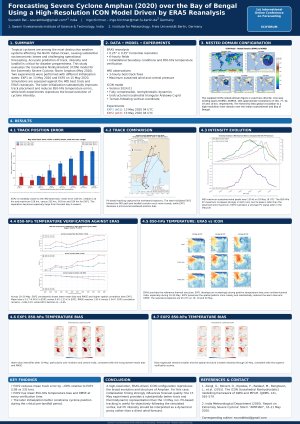
Tropical cyclones are among the most destructive weather systems affecting the North Indian Ocean region, causing substantial socioeconomic losses and posing significant challenges for operational forecasting. Accurate prediction of cyclone track, intensity, and landfall remains crucial for disaster preparedness and risk reduction. In this study, the performance of the Icosahedral Nonhydrostatic (ICON) model is evaluated in forecasting the Extremely Severe Cyclonic Storm Amphan, which developed over the Bay of Bengal during May 2020.
The ICON model was configured using ERA5 reanalysis data as initial and lateral boundary conditions and integrated for ten days using a nested-domain framework with horizontal resolutions ranging from 160 km to 1.2 km. Three forecast experiments were conducted with different initialization dates (10, 13, and 15 May 2020) to assess forecast sensitivity and predictability. Model outputs were validated against IMDAA reanalysis and observations from the India Meteorological Department (IMD).
Results indicate that the high-resolution ICON configuration successfully reproduced the major characteristics of Cyclone Amphan, including its track evolution, intensity changes, and landfall timing. Statistical analyses reveal a slight overestimation of storm intensity and structural organization; however, the model demonstrated considerable skill in predicting cyclone movement and landfall location. Among the experiments, the simulation initialized on 15 May 2020 exhibited the highest forecasting accuracy, suggesting improved predictability with reduced lead time. The findings highlight the capability of convection-permitting ICON simulations to provide reliable forecasts of severe tropical cyclones over the Bay of Bengal and demonstrate their potential application in operational forecasting and early-warning systems for disaster risk reduction.
Keywords
Tropical Cyclone Amphan
ICON Model
Forecast Verification
Bay of Bengal
High-Resolution Modeling
Tropical Cyclone Prediction
Poster
Final_poster_Amphan_ICON_SciForum_A0_Poster_Final.pdf
Online Conditional KAN-Based Forecasting for Practical Time-Series Anomaly Detection
A Receding-Horizon Decision-Focused Learning Framework for Cost-Optimal Battery Scheduling in Microgrids