Event submissions
Published
This submission belongs to the session S7. Atmospheric Techniques, Instruments and Modeling of the event The 8th International Electronic Conference on Atmospheric Sciences
Published date
09 Oct, 2026
Academic Editor
'%3e%3cpath%20d='M12.6657%2010.9104C12.4185%2010.325%2012.0599%209.79327%2011.6097%209.34482C11.1609%208.89508%2010.6293%208.5365%2010.0442%208.28888C10.0389%208.28626%2010.0337%208.28495%2010.0285%208.28233C10.8446%207.69279%2011.3752%206.73249%2011.3752%205.64904C11.3752%203.8542%209.92103%202.39999%208.1262%202.39999C6.33136%202.39999%204.87715%203.8542%204.87715%205.64904C4.87715%206.73249%205.40774%207.69279%206.22393%208.28364C6.21869%208.28626%206.21345%208.28757%206.20821%208.29019C5.62129%208.5378%205.09463%208.89284%204.64265%209.34613C4.1929%209.79493%203.83432%2010.3266%203.58671%2010.9117C3.34345%2011.4845%203.21226%2012.0987%203.20023%2012.7209C3.19988%2012.7349%203.20233%2012.7488%203.20744%2012.7619C3.21255%2012.7749%203.22022%2012.7867%203.22998%2012.7968C3.23975%2012.8068%203.25142%2012.8147%203.26431%2012.8202C3.2772%2012.8256%203.29105%2012.8284%203.30504%2012.8284H4.09109C4.14874%2012.8284%204.19459%2012.7825%204.1959%2012.7262C4.2221%2011.7148%204.62823%2010.7676%205.34617%2010.0497C6.08899%209.30683%207.0755%208.89808%208.1262%208.89808C9.17689%208.89808%2010.1634%209.30683%2010.9062%2010.0497C11.6242%2010.7676%2012.0303%2011.7148%2012.0565%2012.7262C12.0578%2012.7838%2012.1037%2012.8284%2012.1613%2012.8284H12.9474C12.9613%2012.8284%2012.9752%2012.8256%2012.9881%2012.8202C13.001%2012.8147%2013.0126%2012.8068%2013.0224%2012.7968C13.0322%2012.7867%2013.0398%2012.7749%2013.0449%2012.7619C13.0501%2012.7488%2013.0525%2012.7349%2013.0522%2012.7209C13.0391%2012.0947%2012.9094%2011.4855%2012.6657%2010.9104ZM8.1262%207.9024C7.52486%207.9024%206.9589%207.6679%206.53312%207.24211C6.10733%206.81633%205.87283%206.25037%205.87283%205.64904C5.87283%205.0477%206.10733%204.48174%206.53312%204.05596C6.9589%203.63018%207.52486%203.39567%208.1262%203.39567C8.72753%203.39567%209.29349%203.63018%209.71927%204.05596C10.1451%204.48174%2010.3796%205.0477%2010.3796%205.64904C10.3796%206.25037%2010.1451%206.81633%209.71927%207.24211C9.29349%207.6679%208.72753%207.9024%208.1262%207.9024Z'%20fill='%235D1EE1'/%3e%3c/g%3e%3c/svg%3e) Chun-Ho Liu
Chun-Ho LiuCitation
Saleimah Ahmed Alyammahi, Ghayah Ali Abdulateif, Nareiman Khalaf Alkhaaldi, Shaikha Mohammed Alawadhi, Fatmah Mosabbah Alkindi, Maryam Yousuf Alhmoudi, Development and Preliminary Field Evaluation of a Low-Cost Portable Heat Stress Monitoring System for Pedestrian-Level Urban Microclimate Assessment, in Proceedings of The 8th International Electronic Conference on Atmospheric Sciences, 14 October–16 October 2026, MDPI: Basel, Switzerland
Share
Email
Facebook
Twitter
LinkedIn
Development and Preliminary Field Evaluation of a Low-Cost Portable Heat Stress Monitoring System for Pedestrian-Level Urban Microclimate Assessment
'%3e%3cpath%20d='M12.6647%2010.9104C12.4176%2010.325%2012.0589%209.7933%2011.6088%209.34485C11.16%208.89511%2010.6283%208.53653%2010.0432%208.28891C10.038%208.28629%2010.0327%208.28498%2010.0275%208.28236C10.8437%207.69282%2011.3743%206.73252%2011.3743%205.64907C11.3743%203.85423%209.92005%202.40002%208.12522%202.40002C6.33038%202.40002%204.87618%203.85423%204.87618%205.64907C4.87618%206.73252%205.40677%207.69282%206.22296%208.28367C6.21772%208.28629%206.21248%208.2876%206.20724%208.29022C5.62031%208.53783%205.09365%208.89287%204.64167%209.34616C4.19192%209.79496%203.83334%2010.3266%203.58573%2010.9117C3.34247%2011.4846%203.21128%2012.0987%203.19925%2012.721C3.1989%2012.735%203.20135%2012.7489%203.20646%2012.7619C3.21157%2012.7749%203.21924%2012.7868%203.22901%2012.7968C3.23877%2012.8068%203.25045%2012.8148%203.26334%2012.8202C3.27623%2012.8256%203.29007%2012.8284%203.30406%2012.8284H4.09012C4.14776%2012.8284%204.19362%2012.7825%204.19493%2012.7262C4.22113%2011.7148%204.62726%2010.7676%205.34519%2010.0497C6.08802%209.30686%207.07452%208.89811%208.12522%208.89811C9.17592%208.89811%2010.1624%209.30686%2010.9052%2010.0497C11.6232%2010.7676%2012.0293%2011.7148%2012.0555%2012.7262C12.0568%2012.7839%2012.1027%2012.8284%2012.1603%2012.8284H12.9464C12.9604%2012.8284%2012.9742%2012.8256%2012.9871%2012.8202C13%2012.8148%2013.0117%2012.8068%2013.0214%2012.7968C13.0312%2012.7868%2013.0389%2012.7749%2013.044%2012.7619C13.0491%2012.7489%2013.0515%2012.735%2013.0512%2012.721C13.0381%2012.0947%2012.9084%2011.4856%2012.6647%2010.9104ZM8.12522%207.90243C7.52388%207.90243%206.95792%207.66793%206.53214%207.24215C6.10636%206.81636%205.87185%206.2504%205.87185%205.64907C5.87185%205.04773%206.10636%204.48177%206.53214%204.05599C6.95792%203.63021%207.52388%203.3957%208.12522%203.3957C8.72655%203.3957%209.29252%203.63021%209.7183%204.05599C10.1441%204.48177%2010.3786%205.04773%2010.3786%205.64907C10.3786%206.2504%2010.1441%206.81636%209.7183%207.24215C9.29252%207.66793%208.72655%207.90243%208.12522%207.90243Z'%20fill='%235D1EE1'/%3e%3c/g%3e%3c/svg%3e)
Saleimah Ahmed Alyammahi 1
Ghayah Ali Abdulateif 1
Nareiman Khalaf Alkhaaldi 1
Shaikha Mohammed Alawadhi 1
Fatmah Mosabbah Alkindi 1
Maryam Yousuf Alhmoudi 1
1. Engineering Technology & Science Division, Higher Colleges of Technology, Fujairah 4114, United Arab Emirates
Abstract
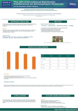
Climate change and rapid urbanization have increased urban heat exposure, posing risks to public health and outdoor workers. Conventional meteorological stations provide regional observations but often fail to capture localized thermal conditions experienced at the pedestrian level. Recent studies have demonstrated the value of portable environmental sensing systems for localized heat monitoring; however, few studies have combined low-cost, portable hardware with real-time Heat Index computation and pedestrian-level field evaluation across diverse urban environments. This study presents the development and preliminary field evaluation of a low-cost portable heat stress monitoring system to address this need. A portable prototype was developed using an ESP32 microcontroller, a DHT11 temperature–humidity sensor, a 20×4 I2C LCD display, and a rechargeable Li-ion battery. The system measures ambient temperature and relative humidity and computes the Heat Index in real time using the NOAA Heat Index equation. Field measurements were conducted at approximately 1.5 m above ground level across four representative urban environments. The field campaign comprised 24 measurements collected across four urban locations, revealing substantial spatial variability in thermal exposure, with Heat Index values differing by up to 11.51°C between locations. Average Heat Index values ranged from 28.43°C indoors to 39.94°C in the shaded parking area, while outdoor air temperatures exceeded 40°C at several sites. The monitoring platform successfully captured differences in pedestrian-level thermal exposure across contrasting environments, demonstrating the feasibility of portable environmental sensing for localized urban microclimate assessment. Although this work represents a preliminary field evaluation and does not include calibration against certified meteorological instruments, it extends existing portable environmental monitoring studies by integrating real-time Heat Index computation with pedestrian-level field measurements using a practical, low-cost portable platform. Future work will incorporate higher accuracy sensors, solar radiation and wind measurements, WBGT estimation, cloud connectivity, GIS-based spatial mapping, and digital-twin integration.
Keywords
urban microclimate
heat stress monitoring
Heat Index
atmospheric monitoring
environmental sensing
Poster
Heat_Stress_Poster_ECAS8_.pdf
Long-Term Changes in Rainfall Regime, Extremes, and Intra-Area Spatial Heterogeneity over the Menkao Region, Kinshasa (DRC), Using CHIRPS Satellite-Based Precipitation Data (1981–2025)
Transport-Derived PM2.5 and Black Carbon Aerosol Burden in West African Megacities: A Source-Attribution and Biofuel-Mitigation Case Study from Lagos, Port Harcourt, and Kano, Nigeria