Event submissions
Published
This submission belongs to the session S1. Air Quality and Human Health of the event The 8th International Electronic Conference on Atmospheric Sciences
Published date
09 Oct, 2026
Academic Editor
'%3e%3cpath%20d='M12.6657%2010.9104C12.4185%2010.325%2012.0599%209.79327%2011.6097%209.34482C11.1609%208.89508%2010.6293%208.5365%2010.0442%208.28888C10.0389%208.28626%2010.0337%208.28495%2010.0285%208.28233C10.8446%207.69279%2011.3752%206.73249%2011.3752%205.64904C11.3752%203.8542%209.92103%202.39999%208.1262%202.39999C6.33136%202.39999%204.87715%203.8542%204.87715%205.64904C4.87715%206.73249%205.40774%207.69279%206.22393%208.28364C6.21869%208.28626%206.21345%208.28757%206.20821%208.29019C5.62129%208.5378%205.09463%208.89284%204.64265%209.34613C4.1929%209.79493%203.83432%2010.3266%203.58671%2010.9117C3.34345%2011.4845%203.21226%2012.0987%203.20023%2012.7209C3.19988%2012.7349%203.20233%2012.7488%203.20744%2012.7619C3.21255%2012.7749%203.22022%2012.7867%203.22998%2012.7968C3.23975%2012.8068%203.25142%2012.8147%203.26431%2012.8202C3.2772%2012.8256%203.29105%2012.8284%203.30504%2012.8284H4.09109C4.14874%2012.8284%204.19459%2012.7825%204.1959%2012.7262C4.2221%2011.7148%204.62823%2010.7676%205.34617%2010.0497C6.08899%209.30683%207.0755%208.89808%208.1262%208.89808C9.17689%208.89808%2010.1634%209.30683%2010.9062%2010.0497C11.6242%2010.7676%2012.0303%2011.7148%2012.0565%2012.7262C12.0578%2012.7838%2012.1037%2012.8284%2012.1613%2012.8284H12.9474C12.9613%2012.8284%2012.9752%2012.8256%2012.9881%2012.8202C13.001%2012.8147%2013.0126%2012.8068%2013.0224%2012.7968C13.0322%2012.7867%2013.0398%2012.7749%2013.0449%2012.7619C13.0501%2012.7488%2013.0525%2012.7349%2013.0522%2012.7209C13.0391%2012.0947%2012.9094%2011.4855%2012.6657%2010.9104ZM8.1262%207.9024C7.52486%207.9024%206.9589%207.6679%206.53312%207.24211C6.10733%206.81633%205.87283%206.25037%205.87283%205.64904C5.87283%205.0477%206.10733%204.48174%206.53312%204.05596C6.9589%203.63018%207.52486%203.39567%208.1262%203.39567C8.72753%203.39567%209.29349%203.63018%209.71927%204.05596C10.1451%204.48174%2010.3796%205.0477%2010.3796%205.64904C10.3796%206.25037%2010.1451%206.81633%209.71927%207.24211C9.29349%207.6679%208.72753%207.9024%208.1262%207.9024Z'%20fill='%235D1EE1'/%3e%3c/g%3e%3c/svg%3e) Daniele Contini
Daniele ContiniCitation
Christopher Morrow, Stephen Benjamin, Observations of Particulate Dispersion Under Stable Atmospheric Conditions Near a Proposed Quarry in Barford, UK, in Proceedings of The 8th International Electronic Conference on Atmospheric Sciences, 14 October–16 October 2026, MDPI: Basel, Switzerland
Share
Email
Facebook
Twitter
LinkedIn
Observations of Particulate Dispersion Under Stable Atmospheric Conditions Near a Proposed Quarry in Barford, UK
'%3e%3cpath%20d='M12.6647%2010.9104C12.4176%2010.325%2012.0589%209.7933%2011.6088%209.34485C11.16%208.89511%2010.6283%208.53653%2010.0432%208.28891C10.038%208.28629%2010.0327%208.28498%2010.0275%208.28236C10.8437%207.69282%2011.3743%206.73252%2011.3743%205.64907C11.3743%203.85423%209.92005%202.40002%208.12522%202.40002C6.33038%202.40002%204.87618%203.85423%204.87618%205.64907C4.87618%206.73252%205.40677%207.69282%206.22296%208.28367C6.21772%208.28629%206.21248%208.2876%206.20724%208.29022C5.62031%208.53783%205.09365%208.89287%204.64167%209.34616C4.19192%209.79496%203.83334%2010.3266%203.58573%2010.9117C3.34247%2011.4846%203.21128%2012.0987%203.19925%2012.721C3.1989%2012.735%203.20135%2012.7489%203.20646%2012.7619C3.21157%2012.7749%203.21924%2012.7868%203.22901%2012.7968C3.23877%2012.8068%203.25045%2012.8148%203.26334%2012.8202C3.27623%2012.8256%203.29007%2012.8284%203.30406%2012.8284H4.09012C4.14776%2012.8284%204.19362%2012.7825%204.19493%2012.7262C4.22113%2011.7148%204.62726%2010.7676%205.34519%2010.0497C6.08802%209.30686%207.07452%208.89811%208.12522%208.89811C9.17592%208.89811%2010.1624%209.30686%2010.9052%2010.0497C11.6232%2010.7676%2012.0293%2011.7148%2012.0555%2012.7262C12.0568%2012.7839%2012.1027%2012.8284%2012.1603%2012.8284H12.9464C12.9604%2012.8284%2012.9742%2012.8256%2012.9871%2012.8202C13%2012.8148%2013.0117%2012.8068%2013.0214%2012.7968C13.0312%2012.7868%2013.0389%2012.7749%2013.044%2012.7619C13.0491%2012.7489%2013.0515%2012.735%2013.0512%2012.721C13.0381%2012.0947%2012.9084%2011.4856%2012.6647%2010.9104ZM8.12522%207.90243C7.52388%207.90243%206.95792%207.66793%206.53214%207.24215C6.10636%206.81636%205.87185%206.2504%205.87185%205.64907C5.87185%205.04773%206.10636%204.48177%206.53214%204.05599C6.95792%203.63021%207.52388%203.3957%208.12522%203.3957C8.72655%203.3957%209.29252%203.63021%209.7183%204.05599C10.1441%204.48177%2010.3786%205.04773%2010.3786%205.64907C10.3786%206.2504%2010.1441%206.81636%209.7183%207.24215C9.29252%207.66793%208.72655%207.90243%208.12522%207.90243Z'%20fill='%235D1EE1'/%3e%3c/g%3e%3c/svg%3e)
Christopher Morrow 1
Stephen Benjamin 2
1. Sand & Gravel Action Committee, Barford Residents Association, Warwick, CV35 8DG, United Kingdom
2. Faculty of Engineering, Environment and Computing, Coventry University, Coventry, CV1 5FB , United Kingdom
Abstract
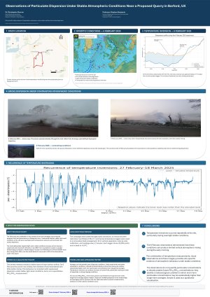
Ground‑level dispersion of particulate matter under stable atmospheric conditions was investigated near the site of a proposed sand and gravel quarry in Barford, Warwickshire. A controlled smoke release was used as a qualitative analogue for PM₁₀ and PM₂.₅ transport, with plume evolution documented using a commercially available drone providing high‑resolution aerial imagery (“the drone provided a high‑resolution visual perspective” ). Atmospheric stability was characterised using low‑cost Elitetech RC‑5+ temperature data loggers, deployed at two elevations and suitably calibrated through a 28‑day side‑by‑side comparison (“the two loggers were situated side by side…for a period of 28 days” and “the average temperature difference…was stable at around 0.4 °C” ). Measurements on 6 February 2025 revealed a pronounced early‑morning inversion, with low‑level air up to 4–5 °C colder than air 32 m higher. Under these conditions, smoke exhibited minimal vertical mixing, lateral meandering, and severely restricted dilution, indicating poor dispersion capacity between the quarry boundary and Barford village. Comparative tests under stronger winds and near‑neutral stability on 2 February 2025 showed markedly greater plume transport. The findings demonstrate that frequent nocturnal inversions in this rural topography can lead to elevated short‑term pollutant concentrations and highlight limitations of standard dispersion models under light‑wind, stable conditions.
This study was conducted by Barford Residents Association as an evidence gathering exercise to support the campaign to prevent the development of a sand and gravel quarry in close (350 m) proximity to the village and the local school. The campaign is funded entirely by public donations and grants from local charitable organisations, so an innovative cost-efficient method of conducting the observations had to be devised. For further information on the proposed quarry and the campaign, see www.stopthebarfordquarry.org.
Keywords
particulate dispersion
stable atmosphere
human health
Poster
Sciforum-191030.pdf
Enhancing PM2.5 Formation Indicator for Human Health: A Coupled Territorial LCA and Multi-Scale Atmospheric Modelling Approach
Cold-Air Pools and PM2.5 Exceedance Risk Across California