Event submissions
Published
This submission belongs to the session S4. Climatology of the event The 8th International Electronic Conference on Atmospheric Sciences
Published date
09 Oct, 2026
Academic Editor
'%3e%3cpath%20d='M12.6657%2010.9104C12.4185%2010.325%2012.0599%209.79327%2011.6097%209.34482C11.1609%208.89508%2010.6293%208.5365%2010.0442%208.28888C10.0389%208.28626%2010.0337%208.28495%2010.0285%208.28233C10.8446%207.69279%2011.3752%206.73249%2011.3752%205.64904C11.3752%203.8542%209.92103%202.39999%208.1262%202.39999C6.33136%202.39999%204.87715%203.8542%204.87715%205.64904C4.87715%206.73249%205.40774%207.69279%206.22393%208.28364C6.21869%208.28626%206.21345%208.28757%206.20821%208.29019C5.62129%208.5378%205.09463%208.89284%204.64265%209.34613C4.1929%209.79493%203.83432%2010.3266%203.58671%2010.9117C3.34345%2011.4845%203.21226%2012.0987%203.20023%2012.7209C3.19988%2012.7349%203.20233%2012.7488%203.20744%2012.7619C3.21255%2012.7749%203.22022%2012.7867%203.22998%2012.7968C3.23975%2012.8068%203.25142%2012.8147%203.26431%2012.8202C3.2772%2012.8256%203.29105%2012.8284%203.30504%2012.8284H4.09109C4.14874%2012.8284%204.19459%2012.7825%204.1959%2012.7262C4.2221%2011.7148%204.62823%2010.7676%205.34617%2010.0497C6.08899%209.30683%207.0755%208.89808%208.1262%208.89808C9.17689%208.89808%2010.1634%209.30683%2010.9062%2010.0497C11.6242%2010.7676%2012.0303%2011.7148%2012.0565%2012.7262C12.0578%2012.7838%2012.1037%2012.8284%2012.1613%2012.8284H12.9474C12.9613%2012.8284%2012.9752%2012.8256%2012.9881%2012.8202C13.001%2012.8147%2013.0126%2012.8068%2013.0224%2012.7968C13.0322%2012.7867%2013.0398%2012.7749%2013.0449%2012.7619C13.0501%2012.7488%2013.0525%2012.7349%2013.0522%2012.7209C13.0391%2012.0947%2012.9094%2011.4855%2012.6657%2010.9104ZM8.1262%207.9024C7.52486%207.9024%206.9589%207.6679%206.53312%207.24211C6.10733%206.81633%205.87283%206.25037%205.87283%205.64904C5.87283%205.0477%206.10733%204.48174%206.53312%204.05596C6.9589%203.63018%207.52486%203.39567%208.1262%203.39567C8.72753%203.39567%209.29349%203.63018%209.71927%204.05596C10.1451%204.48174%2010.3796%205.0477%2010.3796%205.64904C10.3796%206.25037%2010.1451%206.81633%209.71927%207.24211C9.29349%207.6679%208.72753%207.9024%208.1262%207.9024Z'%20fill='%235D1EE1'/%3e%3c/g%3e%3c/svg%3e) Eugene Rozanov
Eugene RozanovCitation
Bouamar BAGHDAD, Larbi Barhazi, Jawad EL HIJRI, Abdelkader TALEB, Youssef JAMIL, Mapping Urban Heat Islands in Casablanca (Morocco): Spatial Analysis and Prospects for Mitigation Through Landscape Design, in Proceedings of The 8th International Electronic Conference on Atmospheric Sciences, 14 October–16 October 2026, MDPI: Basel, Switzerland
Share
Email
Facebook
Twitter
LinkedIn
Mapping Urban Heat Islands in Casablanca (Morocco): Spatial Analysis and Prospects for Mitigation Through Landscape Design
'%3e%3cpath%20d='M12.6647%2010.9104C12.4176%2010.325%2012.0589%209.7933%2011.6088%209.34485C11.16%208.89511%2010.6283%208.53653%2010.0432%208.28891C10.038%208.28629%2010.0327%208.28498%2010.0275%208.28236C10.8437%207.69282%2011.3743%206.73252%2011.3743%205.64907C11.3743%203.85423%209.92005%202.40002%208.12522%202.40002C6.33038%202.40002%204.87618%203.85423%204.87618%205.64907C4.87618%206.73252%205.40677%207.69282%206.22296%208.28367C6.21772%208.28629%206.21248%208.2876%206.20724%208.29022C5.62031%208.53783%205.09365%208.89287%204.64167%209.34616C4.19192%209.79496%203.83334%2010.3266%203.58573%2010.9117C3.34247%2011.4846%203.21128%2012.0987%203.19925%2012.721C3.1989%2012.735%203.20135%2012.7489%203.20646%2012.7619C3.21157%2012.7749%203.21924%2012.7868%203.22901%2012.7968C3.23877%2012.8068%203.25045%2012.8148%203.26334%2012.8202C3.27623%2012.8256%203.29007%2012.8284%203.30406%2012.8284H4.09012C4.14776%2012.8284%204.19362%2012.7825%204.19493%2012.7262C4.22113%2011.7148%204.62726%2010.7676%205.34519%2010.0497C6.08802%209.30686%207.07452%208.89811%208.12522%208.89811C9.17592%208.89811%2010.1624%209.30686%2010.9052%2010.0497C11.6232%2010.7676%2012.0293%2011.7148%2012.0555%2012.7262C12.0568%2012.7839%2012.1027%2012.8284%2012.1603%2012.8284H12.9464C12.9604%2012.8284%2012.9742%2012.8256%2012.9871%2012.8202C13%2012.8148%2013.0117%2012.8068%2013.0214%2012.7968C13.0312%2012.7868%2013.0389%2012.7749%2013.044%2012.7619C13.0491%2012.7489%2013.0515%2012.735%2013.0512%2012.721C13.0381%2012.0947%2012.9084%2011.4856%2012.6647%2010.9104ZM8.12522%207.90243C7.52388%207.90243%206.95792%207.66793%206.53214%207.24215C6.10636%206.81636%205.87185%206.2504%205.87185%205.64907C5.87185%205.04773%206.10636%204.48177%206.53214%204.05599C6.95792%203.63021%207.52388%203.3957%208.12522%203.3957C8.72655%203.3957%209.29252%203.63021%209.7183%204.05599C10.1441%204.48177%2010.3786%205.04773%2010.3786%205.64907C10.3786%206.2504%2010.1441%206.81636%209.7183%207.24215C9.29252%207.66793%208.72655%207.90243%208.12522%207.90243Z'%20fill='%235D1EE1'/%3e%3c/g%3e%3c/svg%3e)
Bouamar BAGHDAD 1
Larbi Barhazi 1
Jawad EL HIJRI 1
Abdelkader TALEB 1
Youssef JAMIL 1
1. Higher School of Architecture of Casablanca (EAC), Casablanca, Morocco
Abstract
Increasing urbanization and the growing effects of climate change are exacerbating thermal imbalances within urban areas, contributing to the emergence of urban heat islands (UHIs). This phenomenon results in significantly higher surface and air temperatures in urbanized areas compared to surrounding suburban or rural areas. In Casablanca, which is Morocco’s economic hub, characterized by high building density, increasing land sealing, and a decline in green spaces, UHIs pose a major challenge to public health, thermal comfort, and urban sustainability.
This research aims to characterize the spatial distribution and intensity of urban heat islands (UHIs) across the city of Casablanca using an integrated geomatics approach. The methodology relies on the use of multispectral satellite imagery, the analysis of land surface temperatures (Land Surface Temperature—LST), the calculation of biophysical indices such as the NDVI (Normalized Difference Vegetation Index) and the NDBI (Normalized Difference Built-up Index), as well as the use of Geographic Information Systems (GIS) to produce thematic maps. A cross-analysis of thermal parameters, land use, and socio-spatial characteristics will identify the areas most vulnerable to the phenomenon.
The expected results aim to highlight the relationships between urban morphology, vegetation cover, and thermal intensity, while identifying critical areas requiring priority action. The study will contribute to the development of decision-making tools for urban planning stakeholders by proposing mitigation strategies based on nature-based solutions (NBSs), including the strengthening of the urban green network, the greening of public spaces, and the use of high-albedo materials.
This research is part of an effort to adapt to climate change and promote resilient urban planning capable of reducing the thermal vulnerability of urban populations and improving the environmental quality of the Casablanca metropolitan area.
Keywords
Urban heat island
surface temperature
remote sensing
GIS
Casablanca.
Poster
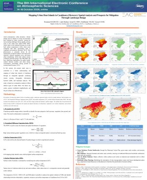
poster-ha-1-English ICU colloque.pdf
CLIMATE RESPONSE TO A TAMBORA-SCALE ERUPTION ACROSS FIVE BACKGROUND CLIMATE STATES
Spatial and Volumetric Reconfiguration of Antarctic Intermediate and Subantarctic Mode Waters.