Event submissions
Published
This submission belongs to the session S7. Atmospheric Techniques, Instruments and Modeling of the event The 8th International Electronic Conference on Atmospheric Sciences
Published date
09 Oct, 2026
Academic Editor
'%3e%3cpath%20d='M12.6657%2010.9104C12.4185%2010.325%2012.0599%209.79327%2011.6097%209.34482C11.1609%208.89508%2010.6293%208.5365%2010.0442%208.28888C10.0389%208.28626%2010.0337%208.28495%2010.0285%208.28233C10.8446%207.69279%2011.3752%206.73249%2011.3752%205.64904C11.3752%203.8542%209.92103%202.39999%208.1262%202.39999C6.33136%202.39999%204.87715%203.8542%204.87715%205.64904C4.87715%206.73249%205.40774%207.69279%206.22393%208.28364C6.21869%208.28626%206.21345%208.28757%206.20821%208.29019C5.62129%208.5378%205.09463%208.89284%204.64265%209.34613C4.1929%209.79493%203.83432%2010.3266%203.58671%2010.9117C3.34345%2011.4845%203.21226%2012.0987%203.20023%2012.7209C3.19988%2012.7349%203.20233%2012.7488%203.20744%2012.7619C3.21255%2012.7749%203.22022%2012.7867%203.22998%2012.7968C3.23975%2012.8068%203.25142%2012.8147%203.26431%2012.8202C3.2772%2012.8256%203.29105%2012.8284%203.30504%2012.8284H4.09109C4.14874%2012.8284%204.19459%2012.7825%204.1959%2012.7262C4.2221%2011.7148%204.62823%2010.7676%205.34617%2010.0497C6.08899%209.30683%207.0755%208.89808%208.1262%208.89808C9.17689%208.89808%2010.1634%209.30683%2010.9062%2010.0497C11.6242%2010.7676%2012.0303%2011.7148%2012.0565%2012.7262C12.0578%2012.7838%2012.1037%2012.8284%2012.1613%2012.8284H12.9474C12.9613%2012.8284%2012.9752%2012.8256%2012.9881%2012.8202C13.001%2012.8147%2013.0126%2012.8068%2013.0224%2012.7968C13.0322%2012.7867%2013.0398%2012.7749%2013.0449%2012.7619C13.0501%2012.7488%2013.0525%2012.7349%2013.0522%2012.7209C13.0391%2012.0947%2012.9094%2011.4855%2012.6657%2010.9104ZM8.1262%207.9024C7.52486%207.9024%206.9589%207.6679%206.53312%207.24211C6.10733%206.81633%205.87283%206.25037%205.87283%205.64904C5.87283%205.0477%206.10733%204.48174%206.53312%204.05596C6.9589%203.63018%207.52486%203.39567%208.1262%203.39567C8.72753%203.39567%209.29349%203.63018%209.71927%204.05596C10.1451%204.48174%2010.3796%205.0477%2010.3796%205.64904C10.3796%206.25037%2010.1451%206.81633%209.71927%207.24211C9.29349%207.6679%208.72753%207.9024%208.1262%207.9024Z'%20fill='%235D1EE1'/%3e%3c/g%3e%3c/svg%3e) Chun-Ho Liu
Chun-Ho LiuCitation
Fahim Sufi, AI-Enabled Atmospheric Hazard Intelligence from Global News Streams: A Geospatial Soft Sensing Framework for Climate-Related Disaster Monitoring, in Proceedings of The 8th International Electronic Conference on Atmospheric Sciences, 14 October–16 October 2026, MDPI: Basel, Switzerland
Share
Email
Facebook
Twitter
LinkedIn
AI-Enabled Atmospheric Hazard Intelligence from Global News Streams: A Geospatial Soft Sensing Framework for Climate-Related Disaster Monitoring

Fahim Sufi 1,2
1. Centre for Trade and Investment (CTI), University of Dhaka, Dhaka 1000, Bangladesh
2. Office of CTO, COEUS Institute, New Market, VA 22844, USA
Abstract
Introduction:
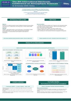
Atmospheric hazards such as hurricanes, floods, wildfires, and extreme weather events produce rapidly changing spatial risk patterns that are conventionally monitored through satellites, meteorological stations, ground observations, and atmospheric models. This study develops an AI-enabled atmospheric hazard intelligence framework that uses global news streams as a complementary soft sensing layer for capturing semantically rich, geographically distributed, and socially reported climate-related hazard signals. Building on a large-scale disaster intelligence corpus, the work advances atmospheric hazard analytics by linking digital reporting patterns with spatial risk interpretation.
Methods:
The study analyses 1.25 million global news articles collected over 514 days from 444 international news portals. Using GPT-based semantic extraction, 17,884 disaster-related reports were transformed into structured geospatial event records spanning 185 countries and 6,068 unique locations. The present analysis focuses on atmospheric and climate-sensitive hazards, including hurricanes, floods, wildfires, and extreme weather events. Extracted variables included hazard type, affected location, temporal context, and risk descriptors. Topic modelling identified dominant atmospheric hazard themes, while chi square tests assessed whether narrative patterns varied across hazard categories and affected countries.
Results:
The framework revealed statistically robust and geographically interpretable atmospheric hazard signals. Narrative composition differed significantly by hazard type, χ² = 25,280.78, p < 0.001, and by affected country, χ² = 23,564.62, p < 0.001, indicating strong spatial heterogeneity in digitally sensed hazard narratives. Distinct signatures included hurricane-associated reporting in the United States, alongside flood and wildfire-related signals across climate-sensitive regions.
Conclusions:
This study establishes global news streams as a complementary digital sensing layer for atmospheric hazard intelligence. By converting unstructured reporting into structured geospatial evidence, the framework supports climate-related disaster monitoring, regional risk comparison, and early-warning-oriented decision support alongside conventional atmospheric observation systems.
Keywords
Atmospheric Hazard Intelligence
Climate Related Disaster Monitoring
GeoAI
Soft Sensing
Extreme Weather Risk Analytics
AI Enabled Environmental Monitoring
Poster
ECAS8_Atmospheric_Hazard_Intelligence_Poster.pdf
Integrated Sample Preparation and TGA-FTIR/μ-FTIR Characterization for the Simultaneous Analysis of Airborne Microplastics and Organic Compounds in Atmospheric Particulate Matter
Meteorological Drivers of Radon Variability and Implications for Human Exposure