Event submissions
Published
This submission belongs to the session S7. Atmospheric Techniques, Instruments and Modeling of the event The 8th International Electronic Conference on Atmospheric Sciences
Published date
09 Oct, 2026
Academic Editor
'%3e%3cpath%20d='M12.6657%2010.9104C12.4185%2010.325%2012.0599%209.79327%2011.6097%209.34482C11.1609%208.89508%2010.6293%208.5365%2010.0442%208.28888C10.0389%208.28626%2010.0337%208.28495%2010.0285%208.28233C10.8446%207.69279%2011.3752%206.73249%2011.3752%205.64904C11.3752%203.8542%209.92103%202.39999%208.1262%202.39999C6.33136%202.39999%204.87715%203.8542%204.87715%205.64904C4.87715%206.73249%205.40774%207.69279%206.22393%208.28364C6.21869%208.28626%206.21345%208.28757%206.20821%208.29019C5.62129%208.5378%205.09463%208.89284%204.64265%209.34613C4.1929%209.79493%203.83432%2010.3266%203.58671%2010.9117C3.34345%2011.4845%203.21226%2012.0987%203.20023%2012.7209C3.19988%2012.7349%203.20233%2012.7488%203.20744%2012.7619C3.21255%2012.7749%203.22022%2012.7867%203.22998%2012.7968C3.23975%2012.8068%203.25142%2012.8147%203.26431%2012.8202C3.2772%2012.8256%203.29105%2012.8284%203.30504%2012.8284H4.09109C4.14874%2012.8284%204.19459%2012.7825%204.1959%2012.7262C4.2221%2011.7148%204.62823%2010.7676%205.34617%2010.0497C6.08899%209.30683%207.0755%208.89808%208.1262%208.89808C9.17689%208.89808%2010.1634%209.30683%2010.9062%2010.0497C11.6242%2010.7676%2012.0303%2011.7148%2012.0565%2012.7262C12.0578%2012.7838%2012.1037%2012.8284%2012.1613%2012.8284H12.9474C12.9613%2012.8284%2012.9752%2012.8256%2012.9881%2012.8202C13.001%2012.8147%2013.0126%2012.8068%2013.0224%2012.7968C13.0322%2012.7867%2013.0398%2012.7749%2013.0449%2012.7619C13.0501%2012.7488%2013.0525%2012.7349%2013.0522%2012.7209C13.0391%2012.0947%2012.9094%2011.4855%2012.6657%2010.9104ZM8.1262%207.9024C7.52486%207.9024%206.9589%207.6679%206.53312%207.24211C6.10733%206.81633%205.87283%206.25037%205.87283%205.64904C5.87283%205.0477%206.10733%204.48174%206.53312%204.05596C6.9589%203.63018%207.52486%203.39567%208.1262%203.39567C8.72753%203.39567%209.29349%203.63018%209.71927%204.05596C10.1451%204.48174%2010.3796%205.0477%2010.3796%205.64904C10.3796%206.25037%2010.1451%206.81633%209.71927%207.24211C9.29349%207.6679%208.72753%207.9024%208.1262%207.9024Z'%20fill='%235D1EE1'/%3e%3c/g%3e%3c/svg%3e) Anthony R. Lupo
Anthony R. LupoCitation
Chi-Ying Chan, Chun-Ho Liu, Drone-Based Measurements of Atmospheric Turbulence in the Roughness Sublayer over a Dense City, in Proceedings of The 8th International Electronic Conference on Atmospheric Sciences, 14 October–16 October 2026, MDPI: Basel, Switzerland
Share
Email
Facebook
Twitter
LinkedIn
Drone-Based Measurements of Atmospheric Turbulence in the Roughness Sublayer over a Dense City
'%3e%3cpath%20d='M12.6647%2010.9104C12.4176%2010.325%2012.0589%209.7933%2011.6088%209.34485C11.16%208.89511%2010.6283%208.53653%2010.0432%208.28891C10.038%208.28629%2010.0327%208.28498%2010.0275%208.28236C10.8437%207.69282%2011.3743%206.73252%2011.3743%205.64907C11.3743%203.85423%209.92005%202.40002%208.12522%202.40002C6.33038%202.40002%204.87618%203.85423%204.87618%205.64907C4.87618%206.73252%205.40677%207.69282%206.22296%208.28367C6.21772%208.28629%206.21248%208.2876%206.20724%208.29022C5.62031%208.53783%205.09365%208.89287%204.64167%209.34616C4.19192%209.79496%203.83334%2010.3266%203.58573%2010.9117C3.34247%2011.4846%203.21128%2012.0987%203.19925%2012.721C3.1989%2012.735%203.20135%2012.7489%203.20646%2012.7619C3.21157%2012.7749%203.21924%2012.7868%203.22901%2012.7968C3.23877%2012.8068%203.25045%2012.8148%203.26334%2012.8202C3.27623%2012.8256%203.29007%2012.8284%203.30406%2012.8284H4.09012C4.14776%2012.8284%204.19362%2012.7825%204.19493%2012.7262C4.22113%2011.7148%204.62726%2010.7676%205.34519%2010.0497C6.08802%209.30686%207.07452%208.89811%208.12522%208.89811C9.17592%208.89811%2010.1624%209.30686%2010.9052%2010.0497C11.6232%2010.7676%2012.0293%2011.7148%2012.0555%2012.7262C12.0568%2012.7839%2012.1027%2012.8284%2012.1603%2012.8284H12.9464C12.9604%2012.8284%2012.9742%2012.8256%2012.9871%2012.8202C13%2012.8148%2013.0117%2012.8068%2013.0214%2012.7968C13.0312%2012.7868%2013.0389%2012.7749%2013.044%2012.7619C13.0491%2012.7489%2013.0515%2012.735%2013.0512%2012.721C13.0381%2012.0947%2012.9084%2011.4856%2012.6647%2010.9104ZM8.12522%207.90243C7.52388%207.90243%206.95792%207.66793%206.53214%207.24215C6.10636%206.81636%205.87185%206.2504%205.87185%205.64907C5.87185%205.04773%206.10636%204.48177%206.53214%204.05599C6.95792%203.63021%207.52388%203.3957%208.12522%203.3957C8.72655%203.3957%209.29252%203.63021%209.7183%204.05599C10.1441%204.48177%2010.3786%205.04773%2010.3786%205.64907C10.3786%206.2504%2010.1441%206.81636%209.7183%207.24215C9.29252%207.66793%208.72655%207.90243%208.12522%207.90243Z'%20fill='%235D1EE1'/%3e%3c/g%3e%3c/svg%3e)
Chi-Ying Chan 1

Chun-Ho Liu 1
1. Department of Mechanical Engineering, The University of Hong Kong, Pokfulam Road, Hong Kong, CHINA
Abstract
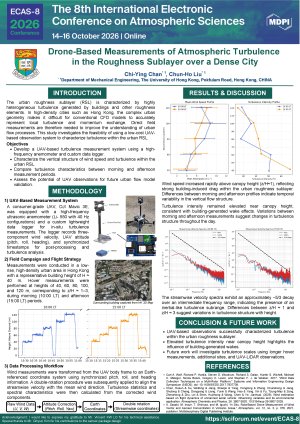
Roughness sublayer (RSL) over dense urban areas is characterized by highly heterogeneous turbulence driven by complex building geometry and spatially varying drag. In cities such as Hong Kong, where building density is extreme, these effects limit the applicability of conventional computational fluid dynamics (CFD) approaches in resolving local flow structures. Field observations within the RSL are therefore essential to improve understanding and support model development. A mobile measurement system was developed using a consumer-grade unmanned aerial vehicle (UAV) equipped with a high-frequency (64 Hz) anemometer mounted above, combined with a ground-based Doppler LiDAR deployed directly beneath the UAV. A tailor-made lightweight data logger enables onboard data acquisition and real-time transmission to a ground station. Field measurements were conducted in a low-rise, high-density urban area in Hong Kong, with a representative mean building height H of approximately 40 meters. Measurements were collected during three periods (10:00, 12:00, and 14:00 LT) within a single day, with ~2 hours of non-continuous flight per period. Flight strategies included hovering at fixed altitudes for 15 minutes, continuous ascent/descent at 1 m s⁻¹, and stepwise descent with 10-meter intervals and 10-second pauses, enabling observations across different elevations z. Preliminary observations reveal strong vertical variability in mean wind speed and turbulence characteristics within the urban roughness sublayer. Wind speed increased rapidly above the canopy top, while turbulence intensity remained elevated near z/H ≈ 1, consistent with building-generated wake effects. Comparisons between morning and afternoon measurements indicate changes in the vertical distribution of turbulent fluctuations, demonstrating the temporal evolution of turbulence structure within the roughness sublayer. Variance analysis further suggests anisotropic turbulence conditions, with horizontal velocity fluctuations generally exceeding vertical fluctuations throughout the observed layer. The UAV measurements complement LiDAR-derived vertical profiles by resolving near-field turbulence features. This study demonstrates the feasibility of integrating UAV-based in situ sensing with ground-based remote sensing to investigate turbulence in urban RSLs. The approach provides a scalable framework for multi-location measurements that supports improved parameterization and validation of urban flow models in complex environments.
Keywords
Roughness Sub-Layer (RSL)
Unmanned Aerial Vehicle (UAV)
Urban Morphology
Poster
ECAS-8_Drone-Based Measurements of Atmospheric Turbulence in the Roughness Sublayer over a Dense City.pdf
Characterization of the shallow structure of fog using categorical machine learning models.
Empirical Ozone Isopleths using a Machine Learning-based Computational Framework