Event submissions
Published
This submission belongs to the session S2. Sustainable Fisheries and Aquaculture Innovations: Combating Overfishing and Advancing Aquatic Health of the event The 1st International Online Conference on Fishes
Published date
03 Nov, 2026
Academic Editor
 Maria Angeles Esteban
Contribution&Funding
Conceptualization,
[João N. Monteiro] ; [Francisco Leitão]
Methodology,
[João N. Monteiro] ; [Francisco Leitão]
Formal analysis,
[João N. Monteiro]
Investigation,
[João N. Monteiro] ; [Francisco Leitão]
Data curation,
[Francisco Leitão]
Writing - original draft,
[João N. Monteiro]
Writing - review,
[editing] ; [João N. Monteiro] ; [Francisco Leitão]
Visualization,
[Francisco Leitão]
Supervision,
[Francisco Leitão]
Funding acquisition,
[Francisco Leitão]
Funding: This study was supported by Project CRUSTAPANHA-Estudo da ecologia, biologia e dinâmica populacional dos pequenos caranguejos com interesse comercial existentes ao longo da costa Portuguesa (Operação 16-01-04-FMP-0005 - CRUSTAPANHA) that was founded by Pr
Citation
João N. Monteiro, Francisco Leitão, Fishing Area Rotativity and Recovery Time in the Estuarine Green Crab Fishery, in Proceedings of The 1st International Online Conference on Fishes, 5 November–6 November 2026, MDPI: Basel, Switzerland
Share
Email
Facebook
Twitter
LinkedIn
Fishing Area Rotativity and Recovery Time in the Estuarine Green Crab Fishery

João N. Monteiro 1

Francisco Leitão 1
1. CCMAR, University of Algarve, Faro, 8005-139, Portugal
Abstract
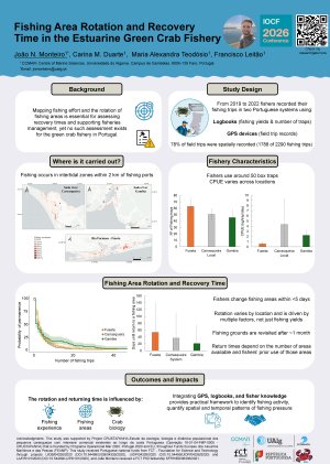
Mapping fishing effort and the rotation of fishing areas is essential for assessing fishery catch rates, fishing area recovery times and supporting fishery management. In contrast to commercial and coastal fisheries, geospatial data for estuarine fisheries remain scarce. In close collaboration with fishers, we conducted a spatial distribution study with the aim of understanding the spatial fishing pressure and rotation areas on the estuarine crab fishery in two Portuguese coastal systems (Sado River and Ria Formosa). Over three years, fishers recorded their fishing trips using logbooks (data, location, fishing yields, and number of traps) and GPS devices (field trip records). A total of 2290 fishing trips were recorded in logbooks, with 1788 of these records having associated GPS tracks, covering 78% of the fishing trips reported in logbooks. Analyses revealed that fishing trips occur in intertidal zones close to fishing ports (<2 km distance) and that fishers change fishing areas frequently (within <5 days). Rotation of fishing areas depends on various factors, not just fishing yields. The recovery time of the fishing areas is around one month and is influenced by the number of fishing areas available per location and the fisher's prior experience in an area, with fishers returning more quickly to areas they visited frequently. In general, returns were rapid since the green crab's fast life cycle and population dynamics enable it to recolonize fishing areas quickly. This study conducted in partnership with fishers demonstrated the feasibility and value of collaboration between science and fishing communities to monitor and understand data-poor fisheries using fishers’ knowledge and low-cost small GPS devices.
Keywords
Carcinus maenas; Spatial distribution; Small scale fisheries; Fishing grounds; GPS devices
Poster
Poster_JNM_SpatialAnalysis.pdf
Anthropogenic particle ingestion by meroplanktonic fish larvae across the Guadiana estuary and Ria Formosa lagoon (South of Portugal).
Habitat Suitability Modeling for the Hill-Stream Loach Triplophysa kashmirensis (Hora, 1925): Identifying Optimal Environmental Conditions and Conservation Priorities in the Kashmir Himalaya