Event submissions
Published
This submission belongs to the session S2. Sustainable Fisheries and Aquaculture Innovations: Combating Overfishing and Advancing Aquatic Health of the event The 1st International Online Conference on Fishes
Published date
03 Nov, 2026
Academic Editor
 Maria Angeles Esteban
Citation
Venecia Albarrán Gervacio, Design of upgrading strategies for the resilience of fishing communities in the Tres Palos lagoon, Acapulco, Mexico, in Proceedings of The 1st International Online Conference on Fishes, 5 November–6 November 2026, MDPI: Basel, Switzerland
Share
Email
Facebook
Twitter
LinkedIn
Design of upgrading strategies for the resilience of fishing communities in the Tres Palos lagoon, Acapulco, Mexico

Venecia Albarrán Gervacio 1
1. Center for Research and Graduate Studies in Socio-territorial Studies, Acapulco Campus (CIPES, Acapulco), Autonomous University of Guerrero, Acapulco, 39390, Mexico
Abstract
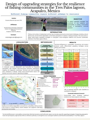
The loss of cultural identity in fishing communities of developing countries is increasingly evident due to population growth, low economic development, and the absence of inclusive sustainable development policies. This research proposes a methodology for designing upgrading strategies aimed at strengthening the social and environmental resilience of fishing communities in Tres Palos Lagoon, Mexico. A multiscalar spatial analysis was conducted by integrating thematic cartography, Geographic Information Systems (GIS), semi-structured interviews, and participatory mapping. A total of 102 actors, including fishers, authorities, social organizations, and academic experts, participated in the study. The results identified lack of participation and trust as the only problem consistently recognized by all stakeholder groups, alongside environmental concerns such as illegal wastewater discharges, lagoon siltation, mangrove degradation, and weak fisheries management. Spatial analysis revealed significant territorial differences among communities in terms of vulnerability, connectivity, tourism pressure, fishery practices, and livelihood conditions. Fisheries assessment showed that 72% of the evaluated fisheries were classified as overfished or collapsed, highlighting the need for urgent management interventions. In contrast, livelihood analysis indicated moderate livelihood conditions (Livelihood Index = 0.52) but high subjective well-being (0.78), demonstrating the strong cultural identity and social attachment of local fishers to their occupation. The study demonstrates that upgrading strategies must be differentiated according to local territorial conditions. In coastal areas with high tourism pressure, such as San Andrés Playa Encantada and Barra Vieja, integrating artisanal fishing with ecotourism and environmental education is recommended. In less connected communities, such as San Pedro Las Playas and El Arenal, priorities include strengthening local value chains, community-based resource management, and participatory governance. The integration of geographic tools and participatory methodologies proved effective for designing valorization policies that recognize territorial diversity, strengthen socio-ecological resilience, and promote fishery sustainability.
Keywords
Community identity
coastal fishing
participatory methodologies
Poster
Design of upgrading strategies_Venecia Albarran.pdf
Distribution of microplastics in water, sediment and fish from the Krka River
Production–profitability trade-offs in amazonian round fish farming: the role of production system and genetic group