Event submissions
Published
This submission belongs to the session S4. Artificial Intelligence Applications for Drones of the event Drones 2026: Mapping the Knowledge
Published date
12 Nov, 2026
Citation
Hitoshi Miyamoto, Monitoring Temporal Changes in Fluvial Land Cover Using Deep Learning and Ultra-High-Resolution Drone Imagery, in Proceedings of Drones 2026: Mapping the Knowledge, Barcelona, 11 November–13 November 2026, MDPI: Basel, Switzerland
Share
Email
Facebook
Twitter
LinkedIn
Monitoring Temporal Changes in Fluvial Land Cover Using Deep Learning and Ultra-High-Resolution Drone Imagery

Hitoshi Miyamoto 1
1. Shibaura Institute of Technology
Abstract
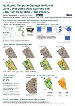
Accurate monitoring of fluvial land cover is essential for understanding river dynamics and assessing flood-induced geomorphological changes. This study investigated temporal changes in fluvial land cover using ultra-high-resolution drone imagery and a deep learning approach. The drone images were acquired from 51 river reaches along the Kinu River in Japan between 2015 and 2019. RGB orthomosaic images were generated from aerial photographs using Structure-from-Motion (SfM) photogrammetry, providing a spatial resolution of approximately 4 cm per pixel. The deep learning method employed was the CNN-Supervised Classification framework (Miyamoto and Ishii, 2023; Carbonneau et al., 2020), which incorporates a two-stage convolutional neural network. Seven land cover classes were identified: gravel, sand, tree, grass, farmland, water surface, and artificial land. The trained model performed pixel-based classification of RGB orthomosaic images, achieving a weighted-average F-measure exceeding 90%, demonstrating that deep learning can accurately classify detailed fluvial land cover at ultra-high spatial resolution. Application of the trained model to the Kinu River imagery successfully revealed temporal changes in both fluvial land cover and geomorphological features, including stream channels, gravel bars, sandbars, and riparian vegetation. In particular, the analysis clearly captured significant landscape changes associated with the severe 2019 flood event, quantitatively identifying abrupt channel migration and extensive vegetation loss. These results demonstrate that combining deep learning with ultra-high-resolution drone imagery provides an effective framework for detailed riverine land cover mapping and quantitative assessment of geomorphological change. The proposed approach offers a practical tool for rapid post-flood damage assessment and supports long-term, large-scale monitoring of river environments, contributing to more efficient river management and conservation.
Keywords
AI Application
UAV
fluvial geomorphology
river management
Poster
Drones_2026_Poster_pi.pdf
Attention Focusing and Division of Labour in Swarm Warfare
Drones and Drone Swarms: Key Players in Securing Critical Infrastructures