Event submissions
Published
This submission belongs to the session S5. Drones in Rangelands, Agriculture, and Forestry of the event Drones 2026: Mapping the Knowledge
Published date
12 Nov, 2026
Contribution&Funding
Resources,
[Tytus Jan Berbec]
Funding: The presented work was financed by the Ministry of Agriculture and Rural Development through a targeted grant for research task 1.8, entitled "The Use of Drones in Agriculture".
Citation
Tytus Jan Berbec, Drones vs. Satellites: A comparative analysis of Low- and High-altitude imagery in cereal crop mapping, in Proceedings of Drones 2026: Mapping the Knowledge, Barcelona, 11 November–13 November 2026, MDPI: Basel, Switzerland
Share
Email
Facebook
Twitter
LinkedIn
Drones vs. Satellites: A comparative analysis of Low- and High-altitude imagery in cereal crop mapping

Tytus Jan Berbec 1
1. Department of Bioeconomy and Agrometeorology, Institute of Soil Science and Plant Cultivation- State Research Institute, Pulawy, 24-100, Poland
Abstract
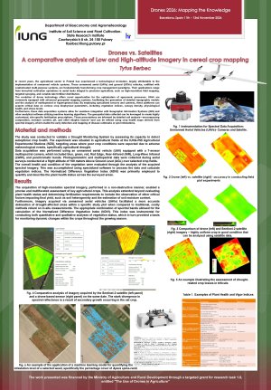
The development of unmanned aerial vehicle (UAV) technology is significantly transforming crop management methods in precision agriculture, enabling high-resolution field mapping as well as the assessment of plants' physiological health and stress levels. The aim of the conducted research was to validate the Drought Monitoring System at the IUNG-PIB Agricultural Experimental Stations in terms of its effectiveness in detecting suboptimal crop conditions caused by agricultural drought.
Data acquisition was based on UAV flights performed at an altitude of 100 meters (AGL), utilizing a seven-sensor multispectral camera covering blue, green, red, Red Edge, near-infrared (NIR), long-wave infrared (LWIR), and panchromatic bands. The Normalized Difference Vegetation Index (NDVI) was primarily used for the quantitative and qualitative assessment of vegetation status.
The obtained high-resolution spectral imagery enabled a precise, non-destructive assessment of key agricultural crops, taking into account not only plant health status and fertilizer requirements but also the estimation of soil moisture and soil heterogeneity. It was demonstrated that UAV-based imagery allows for a more accurate delineation of drought-affected areas (including crop losses in triticale) compared to traditional in situ measurements. A direct comparative analysis of satellite imagery from the Sentinel-2 system and drone imagery recorded on the same date revealed stark divergences in spectral reflectance resulting from the secondary growth of the oat crop. Furthermore, the collected data was used to map Land Surface Temperature (LST) for the purpose of calculating Potential Evapotranspiration (ETP), as well as to test machine learning algorithms to quantify the percentage cover of weeds (e.g., Apera spica-venti). The application of the NDVI based on spectral data provides a reliable basis for monitoring dynamic changes in crops throughout the growing season.
Author: Tytus Berbeć (IUNG-PIB)
Keywords
drones (UAV)
precision agriculture,
multispectral imagery ,
crop mapping
Poster
Poster 1_ Drony vs. Satelity_Drones_2026_TB.pdf
Development of Safety Metrics for Urban Air Mobility operations—The case of people transportation
Scaling Up the Structural Assessment of Ageing Bridges with UAVs