Event submissions
Published
This submission belongs to the session S3. Guidance, Navigation, and Control of the event Drones 2026: Mapping the Knowledge
Published date
12 Nov, 2026
Contribution&Funding
Conceptualization,
[Awantha Jayasiri]
Methodology,
[Ravindu Thalagala]
Validation,
[Ravindu Thalagala] ; [Awantha Jayasiri]
Formal analysis,
[Ravindu Thalagala]
Investigation,
[Ravindu Thalagala] ; [Awantha Jayasiri]
Resources,
[Awantha Jayasiri]
Funding: National Research Council of Canada
Citation
Ravindu Thalagala, Awantha Jayasiri, Spatiotemporal Multi-Modal Sensor Synchronization for High-Speed Aerial Platforms, in Proceedings of Drones 2026: Mapping the Knowledge, Barcelona, 11 November–13 November 2026, MDPI: Basel, Switzerland
Share
Email
Facebook
Twitter
LinkedIn
Spatiotemporal Multi-Modal Sensor Synchronization for High-Speed Aerial Platforms

Ravindu Thalagala 1
Awantha Jayasiri 1
1. Flight Research Lab, National Research Council, Ottawa, K1V 9B4, Canada
Abstract
Recent advances in visual–inertial navigation and tightly coupled LiDAR–inertial odometry have improved the accuracy and robustness of aerial state estimation. Field deployments have also demonstrated the practical use of synchronized visual, inertial, and LiDAR sensing on unmanned aircraft and full-scale rotorcraft. However, state-estimation performance becomes increasingly sensitive to temporal and spatial alignment as vehicle speed increases. Sensor time-lag, communication delay, and processing latency can introduce significant spatial errors in highly dynamic flight. At typical operating speeds, a millisecond-scale timing errors can produce significant displacement between sensor measurements and estimated state.
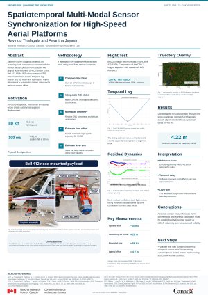
This paper presents a framework for spatiotemporal synchronization of an OPAL3 LiDAR with the Inertial Navigation System of the Bell 412 Advanced Systems Research Aircraft. The method addresses nondeterministic delays associated with software timestamping, operating-system scheduling, data transmission, and sensor communication.
The proposed method first transforms raw measurements from an aerospace-grade inertial navigation system to a common GPS-referenced Unix time base. The time-aligned measurements are then interpolated to account for differences in sensor sampling rates and to establish corresponding LiDAR and inertial trajectories. A grid-search optimization is then applied to estimate the temporal offset by minimizing the trajectory root-mean-square error. When temporal alignment is achieved, spatial calibration is performed using linear least-squares estimation to determine the three-dimensional lever-arm between the LiDAR and inertial reference frames.
Experimental flight data are used to validate the proposed framework. The results demonstrate that deterministic timestamping, temporal-offset compensation, and accurate lever-arm estimation improve trajectory estimation accuracy. The proposed approach provides a repeatable synchronization framework for multimodal state estimation on highly dynamic aerial platforms. It establishes a common and traceable time base and improves the reliability of LiDAR–inertial sensor fusion in demanding flight environments.
Keywords
state estimation
sensor fusion
LiDAR
IMU
helicopter
Poster
DRONES2026_OPAL3_Ravindu_Q.pdf
Uncertainty-Aware FLARM-Based Conflict Detection for Low-Altitude UAS Operations
MD-MCTS: Multimodal Determinized Monte Carlo Tree Search for UAV Multi-Target Rendezvous