Event submissions
Published
This submission belongs to the session S3. Guidance, Navigation, and Control of the event Drones 2026: Mapping the Knowledge
Published date
12 Nov, 2026
Contribution&Funding
Conceptualization,
[Spyridon Tsilimpokos] ; [George Dimitrakopoulos] ; [Ilias Panagiotopoulos]
Methodology,
[Spyridon Tsilimpokos] ; [George Dimitrakopoulos] ; [Ilias Panagiotopoulos]
Software,
[Spyridon Tsilimpokos]
Validation,
[Spyridon Tsilimpokos]
Formal analysis,
[Spyridon Tsilimpokos]
Investigation,
[Spyridon Tsilimpokos]
Resources,
[Spyridon Tsilimpokos]
Data curation,
[Spyridon Tsilimpokos]
Writing - original draft,
[Spyridon Tsilimpokos] ; [George Dimitrakopoulos] ; [Ilias Panagiotopoulos]
Writing - review,
[editing] ; [Ilias Panagiotopoulos] ; [George Dimitrakopoulos] ; [Spyridon Tsilimpokos]
Visualization,
[Spyridon Tsilimpokos]
Supervision,
[Ilias Panagiotopoulos] ; [George Dimitrakopoulos]
Project administration,
[Ilias Panagiotopoulos] ; [George Dimitrakopoulos]
Funding: --
Citation
Spyridon Tsilimpokos, Ilias Panagiotopoulos, George Dimitrakopoulos, From Threat Intelligence to Safe Paths: Cooperative UAV–UGV Navigation in Contested Urban Search and Rescue, in Proceedings of Drones 2026: Mapping the Knowledge, Barcelona, 11 November–13 November 2026, MDPI: Basel, Switzerland
Share
Email
Facebook
Twitter
LinkedIn
From Threat Intelligence to Safe Paths: Cooperative UAV–UGV Navigation in Contested Urban Search and Rescue

Spyridon Tsilimpokos 1

Ilias Panagiotopoulos 2

George Dimitrakopoulos 1
1. Informatics and Telematics, Harokopio University, Greece
2. Military Sciences, Hellenic Army Academy, Greece
Abstract
Autonomous Ground Vehicle (UGV) navigation in contested urban search-and-rescue (SAR) settings must balance mission completion against exposure to mobile adversaries whose positions are known only from aging, intermittent observations. This work presents a cooperative UAV-UGV navigation framework in which an aerial agent supplies threat intelligence to a ground agent running a risk-aware A* path planner over a real urban road graph. The core contribution is a temporal decay threat model that attenuates each adversary detection's influence as a continuous function of observation age, combining exponential confidence decay with a worst-case reachability-expanding uncertainty radius, integrated directly into the planner's edge-cost function. Five UAV coverage strategies, no UAV, lawnmower, threat-informed, target-informed, and a novel phase-scheduled hybrid, were evaluated across 300 simulated missions on an OpenStreetMap-derived road network, scored by a composite Mission Performance Index (mission success, adversary containment, time efficiency). At standard adversary density, threat-informed aerial coverage achieves the highest UGV success rate. At triple density, no UAV-assisted strategy outperforms the baseline on the composite index, revealing a critical density threshold, bounded empirically between the two tested densities, beyond which the UAV coordination overhead becomes net-negative for ground-agent performance. The results carry direct design implications for density-conditional UAV deployment policies in multi-tier autonomous SAR systems.
Keywords
UAV–UGV Cooperation; Temporal Threat Modeling; Risk-Aware Navigation; Autono-mous Search and Rescue; Multi-Agent Coordination
Poster
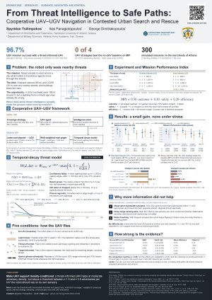
Drones2026_A0-poster-presentation_Panagiotopoulos_(Sciforum-210554).pdf
Genetic Algorithm for Terrain-Optimized Routing for UAV and eVTOL Corridor Navigation
Threat-Aware Trajectory Planning for Full-Scale Helicopters