Event submissions
Published
This submission belongs to the session S8. Emerging Applications of Drones of the event Drones 2026: Mapping the Knowledge
Published date
12 Nov, 2026
Citation
Pietro Grassi, Luca Mantuano, Marco Manzoni, Stefano Moro, Stefano Tebaldini, UAV-based Synthetic Aperture Radar: state of the art and the road ahead, in Proceedings of Drones 2026: Mapping the Knowledge, Barcelona, 11 November–13 November 2026, MDPI: Basel, Switzerland
Share
Email
Facebook
Twitter
LinkedIn
UAV-based Synthetic Aperture Radar: state of the art and the road ahead

Pietro Grassi 1
Luca Mantuano 1
Marco Manzoni 1
Stefano Moro 2

Stefano Tebaldini 1
1. Politecnico di Milano
2. Aresys s.r.l.
Abstract
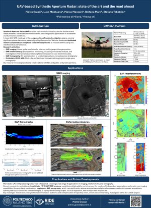
In recent years, Unmanned Aerial Vehicle (UAV)-based Synthetic Aperture Radar (SAR) has seen an unprecedented growth in both the scientific and industrial communities. The low initial and operational costs, the high flexibility of the platform, the increased reliability and accuracy of navigation units, and the simplified regulatory procedures for flight operations are just a few of the key factors that make UAVs an attractive platform for remotely sensing natural or anthropogenic scenarios using SAR.
The technology behind SAR is rather simple: while the UAV is flying, the radar payload transmits pulses and records the echoes. By jointly processing these echoes, a high-resolution image of the scene can be formed. The images are weather-independent, and they can be formed day and night.
The peculiarity of UAVs is that they allow for complete freedom (within the laws of the country where the UAV is flying) about the design of the trajectory including the height, the shape (circular, linear, elliptical, spiral-like, and so on), the velocity and, most importantly, the repetition frequency to observe the scene multiple times with a temporal baseline that can range from seconds to hours or days. This freedom of operation opens the possibility for a large number of applications, such as change detection using amplitude images, deformation monitoring using SAR Interferometry, under-foliage imaging, snowpack analysis using SAR Tomography, agricultural monitoring, search and rescue in hostile environments, and many more. The contribution also discusses emerging technological trends and future application scenarios, including multistatic and distributed SAR imaging, cooperative UAV swarms, autonomous sensing systems, and other next-generation remote sensing paradigms.
Keywords
Synthetic Aperture Radar
SAR
UAV-SAR
Interferometry
Tomography
Poster
PosterDrones.pdf
From Source to Sea: UAV-Based Monitoring of Plastic Litter in Water and Coastal Environments
Mar_Spectra: A UAV-Based Spectroradiometric Platform for Above-Water Environmental Monitoring