Event submissions
Published

This submission belongs to the session F. New sensors, New Methods and Technologies, New Approaches of the event The 5th International Electronic Conference on Water Sciences
Published date
12 Nov, 2020
Citation
xiuwan yin, li zhang, wenting luo, Mapping wetland characteristics using temporally dense Sentinel-1and Sentinel-2data in Poyang lake, in Proceedings of The 5th International Electronic Conference on Water Sciences, 16 November–30 November 2020, MDPI: Basel, Switzerland, doi: 10.3390/ECWS-5-08027
Share
Email
Facebook
Twitter
LinkedIn
Mapping wetland characteristics using temporally dense Sentinel-1and Sentinel-2data in Poyang lake
'%3e%3cpath%20d='M12.6647%2010.9104C12.4176%2010.325%2012.0589%209.7933%2011.6088%209.34485C11.16%208.89511%2010.6283%208.53653%2010.0432%208.28891C10.038%208.28629%2010.0327%208.28498%2010.0275%208.28236C10.8437%207.69282%2011.3743%206.73252%2011.3743%205.64907C11.3743%203.85423%209.92005%202.40002%208.12522%202.40002C6.33038%202.40002%204.87618%203.85423%204.87618%205.64907C4.87618%206.73252%205.40677%207.69282%206.22296%208.28367C6.21772%208.28629%206.21248%208.2876%206.20724%208.29022C5.62031%208.53783%205.09365%208.89287%204.64167%209.34616C4.19192%209.79496%203.83334%2010.3266%203.58573%2010.9117C3.34247%2011.4846%203.21128%2012.0987%203.19925%2012.721C3.1989%2012.735%203.20135%2012.7489%203.20646%2012.7619C3.21157%2012.7749%203.21924%2012.7868%203.22901%2012.7968C3.23877%2012.8068%203.25045%2012.8148%203.26334%2012.8202C3.27623%2012.8256%203.29007%2012.8284%203.30406%2012.8284H4.09012C4.14776%2012.8284%204.19362%2012.7825%204.19493%2012.7262C4.22113%2011.7148%204.62726%2010.7676%205.34519%2010.0497C6.08802%209.30686%207.07452%208.89811%208.12522%208.89811C9.17592%208.89811%2010.1624%209.30686%2010.9052%2010.0497C11.6232%2010.7676%2012.0293%2011.7148%2012.0555%2012.7262C12.0568%2012.7839%2012.1027%2012.8284%2012.1603%2012.8284H12.9464C12.9604%2012.8284%2012.9742%2012.8256%2012.9871%2012.8202C13%2012.8148%2013.0117%2012.8068%2013.0214%2012.7968C13.0312%2012.7868%2013.0389%2012.7749%2013.044%2012.7619C13.0491%2012.7489%2013.0515%2012.735%2013.0512%2012.721C13.0381%2012.0947%2012.9084%2011.4856%2012.6647%2010.9104ZM8.12522%207.90243C7.52388%207.90243%206.95792%207.66793%206.53214%207.24215C6.10636%206.81636%205.87185%206.2504%205.87185%205.64907C5.87185%205.04773%206.10636%204.48177%206.53214%204.05599C6.95792%203.63021%207.52388%203.3957%208.12522%203.3957C8.72655%203.3957%209.29252%203.63021%209.7183%204.05599C10.1441%204.48177%2010.3786%205.04773%2010.3786%205.64907C10.3786%206.2504%2010.1441%206.81636%209.7183%207.24215C9.29252%207.66793%208.72655%207.90243%208.12522%207.90243Z'%20fill='%235D1EE1'/%3e%3c/g%3e%3c/svg%3e)
xiuwan yin 1
li zhang 2
wenting luo 1
1. Jiangxi Normal University
2. Jiang Xi Normal University
Abstract
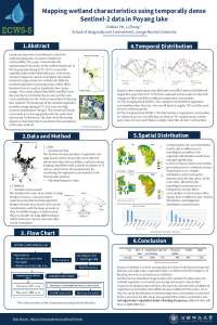
Landscape dynamics of wetland are critical for understanding Lake ecosystem health and sustainability. The paper characterizes the spatiotemporal dynamics of the wetland landscape in the Poyang lake during 2017–2019 to reveal the spatially explicit influential indicators. Time-series Sentinel 2 and Sentinel 1 (C-band) images are used to investigate the spatial-temporal image characters variation for different wetland vegetation in growing season. NDVI, IRECI, Backscattering coefficients, scatter mechanisms will be selected from the Sentinel 2 and Sentinel 1 to study the spectral and structure information of the wetland vegetation. SVM and Random Forest are used to classify the time-series images. The results showed that NDVI and IRECI were the main factors to decide the accuracy of the map. And backscatter coefficients VH polarization and spatial-temporal scatter mechanisms are the good supplement to improve the classification accuracy. Carex and miscanthus are the main communities for Poyang lake wetland. The landscape of the wetland vegetation partially change during 2017-2019 since the high dynamic hydrological changes. The amount of Zizania community is increasing greatly with the water level decreasing. Furthermore, the water level decreasing played an important role to accelerate the swampiness of the Lake wetland.
Keywords
wetland
Multi-level classification
sentinel-1
sentinel-2
multi-sensor
random forest
Poster
sciforum-039173-presentation.pdf
Evaluation of the Impacts of Land Use on Water Quality: A Case Study in Erhai Lake Basin
Evaluation of green-roofs evolution's impact on substrate soil water content by FDR sensors calibration