Event submissions
Published
This submission belongs to the session S1. Technology Enhanced Education of the event The 1st International Online Conference on Education Sciences
Published date
10 Jun, 2026
Academic Editor
'%3e%3cpath%20d='M12.6657%2010.9104C12.4185%2010.325%2012.0599%209.79327%2011.6097%209.34482C11.1609%208.89508%2010.6293%208.5365%2010.0442%208.28888C10.0389%208.28626%2010.0337%208.28495%2010.0285%208.28233C10.8446%207.69279%2011.3752%206.73249%2011.3752%205.64904C11.3752%203.8542%209.92103%202.39999%208.1262%202.39999C6.33136%202.39999%204.87715%203.8542%204.87715%205.64904C4.87715%206.73249%205.40774%207.69279%206.22393%208.28364C6.21869%208.28626%206.21345%208.28757%206.20821%208.29019C5.62129%208.5378%205.09463%208.89284%204.64265%209.34613C4.1929%209.79493%203.83432%2010.3266%203.58671%2010.9117C3.34345%2011.4845%203.21226%2012.0987%203.20023%2012.7209C3.19988%2012.7349%203.20233%2012.7488%203.20744%2012.7619C3.21255%2012.7749%203.22022%2012.7867%203.22998%2012.7968C3.23975%2012.8068%203.25142%2012.8147%203.26431%2012.8202C3.2772%2012.8256%203.29105%2012.8284%203.30504%2012.8284H4.09109C4.14874%2012.8284%204.19459%2012.7825%204.1959%2012.7262C4.2221%2011.7148%204.62823%2010.7676%205.34617%2010.0497C6.08899%209.30683%207.0755%208.89808%208.1262%208.89808C9.17689%208.89808%2010.1634%209.30683%2010.9062%2010.0497C11.6242%2010.7676%2012.0303%2011.7148%2012.0565%2012.7262C12.0578%2012.7838%2012.1037%2012.8284%2012.1613%2012.8284H12.9474C12.9613%2012.8284%2012.9752%2012.8256%2012.9881%2012.8202C13.001%2012.8147%2013.0126%2012.8068%2013.0224%2012.7968C13.0322%2012.7867%2013.0398%2012.7749%2013.0449%2012.7619C13.0501%2012.7488%2013.0525%2012.7349%2013.0522%2012.7209C13.0391%2012.0947%2012.9094%2011.4855%2012.6657%2010.9104ZM8.1262%207.9024C7.52486%207.9024%206.9589%207.6679%206.53312%207.24211C6.10733%206.81633%205.87283%206.25037%205.87283%205.64904C5.87283%205.0477%206.10733%204.48174%206.53312%204.05596C6.9589%203.63018%207.52486%203.39567%208.1262%203.39567C8.72753%203.39567%209.29349%203.63018%209.71927%204.05596C10.1451%204.48174%2010.3796%205.0477%2010.3796%205.64904C10.3796%206.25037%2010.1451%206.81633%209.71927%207.24211C9.29349%207.6679%208.72753%207.9024%208.1262%207.9024Z'%20fill='%235D1EE1'/%3e%3c/g%3e%3c/svg%3e) Mike Joy
Mike JoyCitation
Sandra Beatriz Santachita, Connected Schools: Spatial Implications, Accessibility, and the Digital Divide in Small Towns and Rural Areas, Buenos Aires, in Proceedings of The 1st International Online Conference on Education Sciences, 15 June–17 June 2026, MDPI: Basel, Switzerland
Share
Email
Facebook
Twitter
LinkedIn
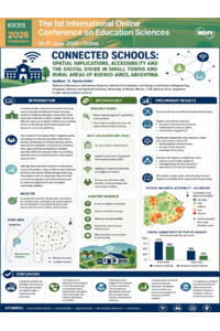
Connected Schools: Spatial Implications, Accessibility, and the Digital Divide in Small Towns and Rural Areas, Buenos Aires

Sandra Beatriz Santachita 1
1. Higher School of Architecture and Design, Morón Campus, University of Morón, Morón, Argentina, Argentina
Abstract
In recent decades, schools have ceased to be mere educational institutions and have become key nodes for territorial cohesion, especially in rural and peripheral areas. In these territories, schools are often the only center of public infrastructure, fulfilling functions such as internet access points, state services, and community meeting places. This phenomenon has given rise to the concept of the "connected school," which integrates spatial, social, technological, and educational factors to contribute to territorial cohesion, a particularly relevant challenge in Argentina, given the fragmentation in physical and digital accessibility.
Although progress has been made in the role of schools as agents of local development, research that comprehensively addresses the interaction between school infrastructure, digital connectivity, and territoriality is still lacking. Educational and technological planning has been sectoral, without considering schools as organizers of territory, especially in rural and peri-urban areas, where problems such as population seasonality and inequality in access to services limit educational quality and territorial coverage.
This project focuses on a case study in rural areas and small towns to understand how schools can promote territorial and digital equity. The research combines quantitative and qualitative approaches, using Geographic Information Systems (GISs) to map school distribution and surveys of teachers and community members about digital connectivity and its social and educational impact.
The results are expected to contribute to improved school infrastructure planning, its role in territorial cohesion, and equitable access to educational and digital resources. Preliminary findings suggest that schools with greater digital connectivity have a positive impact on educational quality and community resilience, reducing territorial and social inequalities.
Keywords
Connected Schools
accessibility and digital divide
small towns
rural areas
Oral Presentation
Poster-2026-escuelas.pptx
Poster
Poster-2026-escuelas.pdf
INTEGRATING AI-POWERED DESIGN TOOLS IN ARCHITECTURE EDUCATION: OPPORTUNITIES, CHALLENGES, AND PEDAGOGICAL IMPLICATIONS IN THE CONTEXT OF BANGLADESH
Bridging the Digital Divide: Scaffolding Postgraduate Academic English Proficiency Through AI-Powered Adaptive Learning Platforms