Event submissions
Published
This submission belongs to the session 5. Digital Tools for Plant Protection of the event The 1st International Electronic Conference on Plant Protection
Published date
01 Mar, 2026
Academic Editor
'%3e%3cpath%20d='M12.6657%2010.9104C12.4185%2010.325%2012.0599%209.79327%2011.6097%209.34482C11.1609%208.89508%2010.6293%208.5365%2010.0442%208.28888C10.0389%208.28626%2010.0337%208.28495%2010.0285%208.28233C10.8446%207.69279%2011.3752%206.73249%2011.3752%205.64904C11.3752%203.8542%209.92103%202.39999%208.1262%202.39999C6.33136%202.39999%204.87715%203.8542%204.87715%205.64904C4.87715%206.73249%205.40774%207.69279%206.22393%208.28364C6.21869%208.28626%206.21345%208.28757%206.20821%208.29019C5.62129%208.5378%205.09463%208.89284%204.64265%209.34613C4.1929%209.79493%203.83432%2010.3266%203.58671%2010.9117C3.34345%2011.4845%203.21226%2012.0987%203.20023%2012.7209C3.19988%2012.7349%203.20233%2012.7488%203.20744%2012.7619C3.21255%2012.7749%203.22022%2012.7867%203.22998%2012.7968C3.23975%2012.8068%203.25142%2012.8147%203.26431%2012.8202C3.2772%2012.8256%203.29105%2012.8284%203.30504%2012.8284H4.09109C4.14874%2012.8284%204.19459%2012.7825%204.1959%2012.7262C4.2221%2011.7148%204.62823%2010.7676%205.34617%2010.0497C6.08899%209.30683%207.0755%208.89808%208.1262%208.89808C9.17689%208.89808%2010.1634%209.30683%2010.9062%2010.0497C11.6242%2010.7676%2012.0303%2011.7148%2012.0565%2012.7262C12.0578%2012.7838%2012.1037%2012.8284%2012.1613%2012.8284H12.9474C12.9613%2012.8284%2012.9752%2012.8256%2012.9881%2012.8202C13.001%2012.8147%2013.0126%2012.8068%2013.0224%2012.7968C13.0322%2012.7867%2013.0398%2012.7749%2013.0449%2012.7619C13.0501%2012.7488%2013.0525%2012.7349%2013.0522%2012.7209C13.0391%2012.0947%2012.9094%2011.4855%2012.6657%2010.9104ZM8.1262%207.9024C7.52486%207.9024%206.9589%207.6679%206.53312%207.24211C6.10733%206.81633%205.87283%206.25037%205.87283%205.64904C5.87283%205.0477%206.10733%204.48174%206.53312%204.05596C6.9589%203.63018%207.52486%203.39567%208.1262%203.39567C8.72753%203.39567%209.29349%203.63018%209.71927%204.05596C10.1451%204.48174%2010.3796%205.0477%2010.3796%205.64904C10.3796%206.25037%2010.1451%206.81633%209.71927%207.24211C9.29349%207.6679%208.72753%207.9024%208.1262%207.9024Z'%20fill='%235D1EE1'/%3e%3c/g%3e%3c/svg%3e) Jorge M. S. Faria
Jorge M. S. FariaCitation
Babur Ali Akbar, Assessing Long-Term Ecological Resilience in Punjab's Paddy-Dominated Agroecosystems through Integrated Geospatial Analysis (2001–2023), in Proceedings of The 1st International Electronic Conference on Plant Protection, 2 March–8 March 2026, MDPI: Basel, Switzerland
Share
Email
Facebook
Twitter
LinkedIn
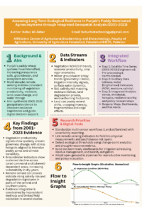
Assessing Long-Term Ecological Resilience in Punjab's Paddy-Dominated Agroecosystems through Integrated Geospatial Analysis (2001–2023)
'%3e%3cpath%20d='M12.6647%2010.9104C12.4176%2010.325%2012.0589%209.7933%2011.6088%209.34485C11.16%208.89511%2010.6283%208.53653%2010.0432%208.28891C10.038%208.28629%2010.0327%208.28498%2010.0275%208.28236C10.8437%207.69282%2011.3743%206.73252%2011.3743%205.64907C11.3743%203.85423%209.92005%202.40002%208.12522%202.40002C6.33038%202.40002%204.87618%203.85423%204.87618%205.64907C4.87618%206.73252%205.40677%207.69282%206.22296%208.28367C6.21772%208.28629%206.21248%208.2876%206.20724%208.29022C5.62031%208.53783%205.09365%208.89287%204.64167%209.34616C4.19192%209.79496%203.83334%2010.3266%203.58573%2010.9117C3.34247%2011.4846%203.21128%2012.0987%203.19925%2012.721C3.1989%2012.735%203.20135%2012.7489%203.20646%2012.7619C3.21157%2012.7749%203.21924%2012.7868%203.22901%2012.7968C3.23877%2012.8068%203.25045%2012.8148%203.26334%2012.8202C3.27623%2012.8256%203.29007%2012.8284%203.30406%2012.8284H4.09012C4.14776%2012.8284%204.19362%2012.7825%204.19493%2012.7262C4.22113%2011.7148%204.62726%2010.7676%205.34519%2010.0497C6.08802%209.30686%207.07452%208.89811%208.12522%208.89811C9.17592%208.89811%2010.1624%209.30686%2010.9052%2010.0497C11.6232%2010.7676%2012.0293%2011.7148%2012.0555%2012.7262C12.0568%2012.7839%2012.1027%2012.8284%2012.1603%2012.8284H12.9464C12.9604%2012.8284%2012.9742%2012.8256%2012.9871%2012.8202C13%2012.8148%2013.0117%2012.8068%2013.0214%2012.7968C13.0312%2012.7868%2013.0389%2012.7749%2013.044%2012.7619C13.0491%2012.7489%2013.0515%2012.735%2013.0512%2012.721C13.0381%2012.0947%2012.9084%2011.4856%2012.6647%2010.9104ZM8.12522%207.90243C7.52388%207.90243%206.95792%207.66793%206.53214%207.24215C6.10636%206.81636%205.87185%206.2504%205.87185%205.64907C5.87185%205.04773%206.10636%204.48177%206.53214%204.05599C6.95792%203.63021%207.52388%203.3957%208.12522%203.3957C8.72655%203.3957%209.29252%203.63021%209.7183%204.05599C10.1441%204.48177%2010.3786%205.04773%2010.3786%205.64907C10.3786%206.2504%2010.1441%206.81636%209.7183%207.24215C9.29252%207.66793%208.72655%207.90243%208.12522%207.90243Z'%20fill='%235D1EE1'/%3e%3c/g%3e%3c/svg%3e)
Babur Ali Akbar 1
1. Centre of Agricultural Biochemistry and Biotechnology, faculty of Agriculture, University of Agriculture Faisalabad, Faisalabad, 64101 , Pakistan, Pakistan
Abstract
The Punjab province of Pakistan, constituting the nation's principal agricultural production region and contributing substantially to national cereal yields, has experienced pronounced agricultural intensification throughout recent decades, precipitating considerable environmental ramifications including progressive soil degradation, catastrophic groundwater table decline, salinization of cultivable lands, and diminishment of ecological integrity. Paddy and wheat cultivation, fundamental to Pakistan's food sovereignty and rural livelihoods, have necessitated escalating resource extraction patterns—particularly irrigation water from the Indus Basin—with demonstrable consequences for landscape-scale ecological health and long-term agro-environmental sustainability trajectories. Remote sensing technologies provide non-invasive, synoptic methodologies for monitoring ecological health indicators across extensive spatial domains and prolonged temporal intervals, yet comprehensive synthesis of Pakistan's spatiotemporal ecological dynamics over multi-decadal periods remains inadequately consolidated within the peer-reviewed scientific literature. This review examines available evidence regarding the spatiotemporal evolution of ecological health parameters across Pakistan's Punjab province from 2001 through 2023, synthesizing remote sensing investigations addressing vegetation productivity indices, soil moisture availability, land cover transformations, aquifer depletion trends, and water resource dynamics in relation to intensive paddy and cereal agriculture. The scientific literature demonstrates consistent degradation of landscape-scale vegetation productivity across substantial portions of Punjab, with normalized difference vegetation index (NDVI) trajectories revealing progressive decline in greenness coinciding with sustained agricultural intensification and climate variability impacts. Concurrent remote sensing assessments document alarming reductions in groundwater table elevations, with multiple lines of evidence from satellite gravimetry and ground-based hydrological monitoring revealing sustained downward trajectories across both canal-command areas and groundwater-dependent cultivation zones dependent upon the Indus irrigation system. Satellite-based evaluations of soil quality indicators, notwithstanding methodological variability across studies, collectively suggest deterioration of critical soil parameters including organic matter content, structural stability, and increasing salinity concentrations across intensively cropped regions. The scientific literature, however, exhibits substantial methodological heterogeneity regarding remote sensing approaches, temporal resolution specifications, spatial coverage extent, and analytical methodologies employed, thereby complicating the formulation of spatially and temporally consistent ecological trend assessments. Relatively few investigations have integrated multiple remote sensing data modalities within coherent analytical frameworks, constraining comprehensive understanding of interconnected ecological transformations spanning soil, water resources, and vegetation systems. The temporal dynamics of ecological health parameters remain incompletely characterized, with insufficient investigation of critical ecological thresholds potentially indicative of irreversible degradation trajectories. This review synthesizes spatiotemporal remote sensing evidence documenting ecological health trajectories across Pakistan's Punjab paddy and cereal production landscapes, critically appraises methodological approaches and inherent limitations, identifies persistent knowledge deficiencies concerning ecological resilience mechanisms and transition point identification, and discusses implications for transition pathways toward genuinely sustainable agricultural intensification. Enhanced understanding of ecological dynamics through integrated remote sensing methodologies could substantiate evidence-based policy development supporting Pakistan's agricultural productivity objectives whilst simultaneously ensuring preservation of regional ecological integrity, safeguarding aquifer sustainability, and supporting long-term food security across vulnerable agroecosystems
Keywords
Punjab province of Pakistan ,environmental ramifications
Remote sensing technologies
paddy and cereal agriculture
Poster
poster babur Ali (1).pdf
Growth-Regulating Activity of Chalcogen-Functionalized Thiazoloquinazolines
Moringa (Moringa oleifera)–Vegetable Agrisilviculture Under Fertilizer Inputs: Evidence Synthesis of Productivity Outcomes, Soil Fertility Trajectories, and Tree–Crop–Soil Mechanisms