Event submissions
Published
This submission belongs to the session S6. Fractal Geometry: Mathematical Foundations and Real-World Applications of the event The 1st International Online Conference on Fractal and Fractional
Published date
08 Apr, 2026
Academic Editor
'%3e%3cpath%20d='M12.6657%2010.9104C12.4185%2010.325%2012.0599%209.79327%2011.6097%209.34482C11.1609%208.89508%2010.6293%208.5365%2010.0442%208.28888C10.0389%208.28626%2010.0337%208.28495%2010.0285%208.28233C10.8446%207.69279%2011.3752%206.73249%2011.3752%205.64904C11.3752%203.8542%209.92103%202.39999%208.1262%202.39999C6.33136%202.39999%204.87715%203.8542%204.87715%205.64904C4.87715%206.73249%205.40774%207.69279%206.22393%208.28364C6.21869%208.28626%206.21345%208.28757%206.20821%208.29019C5.62129%208.5378%205.09463%208.89284%204.64265%209.34613C4.1929%209.79493%203.83432%2010.3266%203.58671%2010.9117C3.34345%2011.4845%203.21226%2012.0987%203.20023%2012.7209C3.19988%2012.7349%203.20233%2012.7488%203.20744%2012.7619C3.21255%2012.7749%203.22022%2012.7867%203.22998%2012.7968C3.23975%2012.8068%203.25142%2012.8147%203.26431%2012.8202C3.2772%2012.8256%203.29105%2012.8284%203.30504%2012.8284H4.09109C4.14874%2012.8284%204.19459%2012.7825%204.1959%2012.7262C4.2221%2011.7148%204.62823%2010.7676%205.34617%2010.0497C6.08899%209.30683%207.0755%208.89808%208.1262%208.89808C9.17689%208.89808%2010.1634%209.30683%2010.9062%2010.0497C11.6242%2010.7676%2012.0303%2011.7148%2012.0565%2012.7262C12.0578%2012.7838%2012.1037%2012.8284%2012.1613%2012.8284H12.9474C12.9613%2012.8284%2012.9752%2012.8256%2012.9881%2012.8202C13.001%2012.8147%2013.0126%2012.8068%2013.0224%2012.7968C13.0322%2012.7867%2013.0398%2012.7749%2013.0449%2012.7619C13.0501%2012.7488%2013.0525%2012.7349%2013.0522%2012.7209C13.0391%2012.0947%2012.9094%2011.4855%2012.6657%2010.9104ZM8.1262%207.9024C7.52486%207.9024%206.9589%207.6679%206.53312%207.24211C6.10733%206.81633%205.87283%206.25037%205.87283%205.64904C5.87283%205.0477%206.10733%204.48174%206.53312%204.05596C6.9589%203.63018%207.52486%203.39567%208.1262%203.39567C8.72753%203.39567%209.29349%203.63018%209.71927%204.05596C10.1451%204.48174%2010.3796%205.0477%2010.3796%205.64904C10.3796%206.25037%2010.1451%206.81633%209.71927%207.24211C9.29349%207.6679%208.72753%207.9024%208.1262%207.9024Z'%20fill='%235D1EE1'/%3e%3c/g%3e%3c/svg%3e) Camillo Porcaro
Camillo PorcaroCitation
Alarcon Matos de Oliveira, Lusanira Nogueira Aragão de Oliveira, Julia Batista Peixoto, The Morphological Mark of Inequality: Fractal Dimension Reveals Structural Spatial Segregation in Alagoinhas (BA)., in Proceedings of The 1st International Online Conference on Fractal and Fractional, 13 April–15 April 2026, MDPI: Basel, Switzerland
Share
Email
Facebook
Twitter
LinkedIn
The Morphological Mark of Inequality: Fractal Dimension Reveals Structural Spatial Segregation in Alagoinhas (BA).
'%3e%3cpath%20d='M12.6647%2010.9104C12.4176%2010.325%2012.0589%209.7933%2011.6088%209.34485C11.16%208.89511%2010.6283%208.53653%2010.0432%208.28891C10.038%208.28629%2010.0327%208.28498%2010.0275%208.28236C10.8437%207.69282%2011.3743%206.73252%2011.3743%205.64907C11.3743%203.85423%209.92005%202.40002%208.12522%202.40002C6.33038%202.40002%204.87618%203.85423%204.87618%205.64907C4.87618%206.73252%205.40677%207.69282%206.22296%208.28367C6.21772%208.28629%206.21248%208.2876%206.20724%208.29022C5.62031%208.53783%205.09365%208.89287%204.64167%209.34616C4.19192%209.79496%203.83334%2010.3266%203.58573%2010.9117C3.34247%2011.4846%203.21128%2012.0987%203.19925%2012.721C3.1989%2012.735%203.20135%2012.7489%203.20646%2012.7619C3.21157%2012.7749%203.21924%2012.7868%203.22901%2012.7968C3.23877%2012.8068%203.25045%2012.8148%203.26334%2012.8202C3.27623%2012.8256%203.29007%2012.8284%203.30406%2012.8284H4.09012C4.14776%2012.8284%204.19362%2012.7825%204.19493%2012.7262C4.22113%2011.7148%204.62726%2010.7676%205.34519%2010.0497C6.08802%209.30686%207.07452%208.89811%208.12522%208.89811C9.17592%208.89811%2010.1624%209.30686%2010.9052%2010.0497C11.6232%2010.7676%2012.0293%2011.7148%2012.0555%2012.7262C12.0568%2012.7839%2012.1027%2012.8284%2012.1603%2012.8284H12.9464C12.9604%2012.8284%2012.9742%2012.8256%2012.9871%2012.8202C13%2012.8148%2013.0117%2012.8068%2013.0214%2012.7968C13.0312%2012.7868%2013.0389%2012.7749%2013.044%2012.7619C13.0491%2012.7489%2013.0515%2012.735%2013.0512%2012.721C13.0381%2012.0947%2012.9084%2011.4856%2012.6647%2010.9104ZM8.12522%207.90243C7.52388%207.90243%206.95792%207.66793%206.53214%207.24215C6.10636%206.81636%205.87185%206.2504%205.87185%205.64907C5.87185%205.04773%206.10636%204.48177%206.53214%204.05599C6.95792%203.63021%207.52388%203.3957%208.12522%203.3957C8.72655%203.3957%209.29252%203.63021%209.7183%204.05599C10.1441%204.48177%2010.3786%205.04773%2010.3786%205.64907C10.3786%206.2504%2010.1441%206.81636%209.7183%207.24215C9.29252%207.66793%208.72655%207.90243%208.12522%207.90243Z'%20fill='%235D1EE1'/%3e%3c/g%3e%3c/svg%3e)
Alarcon Matos de Oliveira 1
Lusanira Nogueira Aragão de Oliveira 2
Julia Batista Peixoto 1
1. Department of Exact and Earth Sciences (DCET II), State University of Bahia (UNEB). Alagoinhas, Bahia, Brazil, Brazil
2. Department of Geography, Faculty of Philosophy, Languages and Human Sciences (FFLCH), University of São Paulo (USP). São Paulo, Brazil, Brazil
Abstract
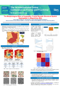
The understanding of urban morphology has been enhanced by mathematical and computational approaches capable of quantifying the spatial complexity of cities. This paper investigates the hypothesis that the fractal complexity of the urban fabric varies significantly as a function of socioeconomic stratification in Alagoinhas, Bahia, Brazil. To this end, the analysis of the Fractal Dimension (FD) was employed on residential samples from three income groups (Class A: R$ 2,000; Class B: R$ 1,000 - 1,500; Class C: R$ 600), aiming to fill a gap in the understanding of the articulation between urban structure and spatial justice. The Box-Counting methodology was applied to 30 georeferenced samples (ten per class), obtained from high-resolution images (Google Earth/CNES) and standardized in square buffers of 200 meters side. The log-log regression analysis for the FD estimation demonstrated high statistical robustness, with the R-squared consistently at 1.000 for all samples. The results revealed that all classes exhibit high density, with FD values close to 2.0. Class A (mean FD 1.992) showed the highest average spatial complexity and the lowest intrinsic variation, suggesting more consolidated and detailed occupation patterns. Class C (mean FD 1.990) demonstrated the highest morphological uniformity (standard deviation of 0.002), reflecting homogeneous and dense occupation patterns, typical of peripheral areas with lower infrastructure. Class B (mean FD 1.988) exhibited the greatest internal variation, characterizing itself as a morphological transition zone. The comparative analysis (regression and K-means) highlighted a complete absence of spatial correlation between Class A and Class C, confirming the hypothesis that socioeconomic segregation manifests in structurally distinct urban patterns. We conclude that the fractal dimension is an effective metric for quantifying inequality in the production of space, demonstrating how social stratification in Alagoinhas is mapped onto its urban morphology.
Keywords
Fractal Dimension (FD)
Urban Morphology
Spatial Segregation
Socioeconomic Stratification Box-Counting
Spatial Justice
Poster
Poster.pdf
Self-similar currents and their properties based on the general theory of fractal elements
Fractal Dimension Analysis: Unlocking Ageing-Related Changes in Brain Criticality