Event submissions
Published
This submission belongs to the session S3. Computing and Artificial Intelligence of the event The 6th International Electronic Conference on Applied Sciences
Published date
03 Dec, 2025
Academic Editor
'%3e%3cpath%20d='M12.6657%2010.9104C12.4185%2010.325%2012.0599%209.79327%2011.6097%209.34482C11.1609%208.89508%2010.6293%208.5365%2010.0442%208.28888C10.0389%208.28626%2010.0337%208.28495%2010.0285%208.28233C10.8446%207.69279%2011.3752%206.73249%2011.3752%205.64904C11.3752%203.8542%209.92103%202.39999%208.1262%202.39999C6.33136%202.39999%204.87715%203.8542%204.87715%205.64904C4.87715%206.73249%205.40774%207.69279%206.22393%208.28364C6.21869%208.28626%206.21345%208.28757%206.20821%208.29019C5.62129%208.5378%205.09463%208.89284%204.64265%209.34613C4.1929%209.79493%203.83432%2010.3266%203.58671%2010.9117C3.34345%2011.4845%203.21226%2012.0987%203.20023%2012.7209C3.19988%2012.7349%203.20233%2012.7488%203.20744%2012.7619C3.21255%2012.7749%203.22022%2012.7867%203.22998%2012.7968C3.23975%2012.8068%203.25142%2012.8147%203.26431%2012.8202C3.2772%2012.8256%203.29105%2012.8284%203.30504%2012.8284H4.09109C4.14874%2012.8284%204.19459%2012.7825%204.1959%2012.7262C4.2221%2011.7148%204.62823%2010.7676%205.34617%2010.0497C6.08899%209.30683%207.0755%208.89808%208.1262%208.89808C9.17689%208.89808%2010.1634%209.30683%2010.9062%2010.0497C11.6242%2010.7676%2012.0303%2011.7148%2012.0565%2012.7262C12.0578%2012.7838%2012.1037%2012.8284%2012.1613%2012.8284H12.9474C12.9613%2012.8284%2012.9752%2012.8256%2012.9881%2012.8202C13.001%2012.8147%2013.0126%2012.8068%2013.0224%2012.7968C13.0322%2012.7867%2013.0398%2012.7749%2013.0449%2012.7619C13.0501%2012.7488%2013.0525%2012.7349%2013.0522%2012.7209C13.0391%2012.0947%2012.9094%2011.4855%2012.6657%2010.9104ZM8.1262%207.9024C7.52486%207.9024%206.9589%207.6679%206.53312%207.24211C6.10733%206.81633%205.87283%206.25037%205.87283%205.64904C5.87283%205.0477%206.10733%204.48174%206.53312%204.05596C6.9589%203.63018%207.52486%203.39567%208.1262%203.39567C8.72753%203.39567%209.29349%203.63018%209.71927%204.05596C10.1451%204.48174%2010.3796%205.0477%2010.3796%205.64904C10.3796%206.25037%2010.1451%206.81633%209.71927%207.24211C9.29349%207.6679%208.72753%207.9024%208.1262%207.9024Z'%20fill='%235D1EE1'/%3e%3c/g%3e%3c/svg%3e) Lucia Billeci
Lucia BilleciCitation
Prajwal Mohapatra, Swayam Subhankar Sahoo, Adyasha Das, Next-Day Forest Fire Risk Prediction Using Machine Learning and Multimodal Satellite Data, in Proceedings of The 6th International Electronic Conference on Applied Sciences, 9 December–11 December 2025, MDPI: Basel, Switzerland
Share
Email
Facebook
Twitter
LinkedIn
Next-Day Forest Fire Risk Prediction Using Machine Learning and Multimodal Satellite Data

Prajwal Mohapatra 1

Swayam Subhankar Sahoo 2

Adyasha Das 2
1. Artificial Intelligence and Robotics Engineering, School of Mechanical Sciences, Odisha University of Technology and Research, Bhubaneswar, India, India
2. Computer Science and Engineering, School of Computer Sciences, Odisha University of Technology and Research, Bhubaneswar, India, India
Abstract
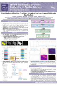
Predicting forest fire occurrence is essential for proactive disaster preparedness and environmental protection. We introduce a machine learning-based system that forecasts next-day fire probability at high spatial resolution using satellite-derived, multi-modal geospatial data. In contrast to existing reactive systems that rely on thermal anomaly detection (e.g., MODIS or VIIRS-SNPP), our approach is fully predictive, generating pixel-wise fire risk maps a day in advance. Our study focuses on Uttarakhand, India, which is an ecologically sensitive region that experiences frequent and severe forest fires. We curated a domain-specific geospatial dataset spanning 1 April to 29 May 2016. It includes daily 30-meter GeoTIFF images with 10 bands comprising weather (e.g., temperature, wind, precipitation), topography (slope, aspect), fuel map, and fire mask. We constructed this dataset from diverse sources and aligned all bands spatially and temporally. To demonstrate the usefulness of this dataset, we implement a deep convolutional neural network (CNN) using the ResUNet-a architecture, chosen for its robust performance in the semantic segmentation of high-resolution remote sensing data. Our model is trained from scratch to produce high-resolution fire probability maps and classify fire/no-fire pixels. Our solution helps with planning and decision-making for early intervention, especially in areas with high risk. It supports UN’s SDG 13 (Climate Action) and SDG 15 (Life on Land) by enhancing resilience and conserving ecosystems. The presented dataset and methodology can serve as a benchmark for future research on wildfire risk prediction using Earth observation data.
Keywords
Forest Fire
Machine Learning
Multi-modal geospatial data
Convolutional Neural Network
ResUNet-a
Semantic segmentation
Poster
ASEC Forest Fire Poster.pdf
Determination of Carbon Monoxide Dynamics in Hemoglobin Subunits Using Singular Value Decomposition and Maximum Entropy Method
Voltammetric sensor based on carbon nanotubes and cerium dioxide nanoparticles for Ponceau 4R