10th International Electronic Conference on Sensors and Applications
Announcement
ECSA-10 is closed.
Thank you for your participation! You may still access the materials of each submission, including the peer-reviewed paper, poster, or presentation, and the recorded Live Sessions. #openaccess
Please note that the recordings are only available to Sciforum users. Register for free today!
The ECSA-10 award winners have been announced at https://ecsa-10.sciforum.net/#awards
the chairs
Welcome from the Conference Chairs of the 10th International Electronic Conference on Sensors and Applications
We are pleased to announce the 10th International Electronic Conference on Sensors and Applications. After the success of the nine editions from 2014 to 2022, this year edition will focus on the following thematic areas where sensors are changing science:
- Chemo- and Biosensors (Session A)
- Physical Sensors (Session B)
- Sensor Networks, IoT and Structural Health Monitoring (Session C)
- Sensor Data Analytics (Session D)
- Sensors and Artificial Intelligence (Session E)
- Student Session (Session F)
- Poster Session (Session G)
There will be five specific sessions:
- S1. Smart Agriculture Sensors
- S2. Materials for Sensing Applications
- S3. Electronic Sensors, Devices and Systems
- S4. Wearable Sensors and Healthcare Applications
- S5. Robotics, Sensors and Industry 4.0
Posters can be presented without an accompanying proceedings paper and will be available online on this website during and after the e-conference.
Participants will have the opportunity to examine, explore and critically engage with issues and advances in these areas. We hope to facilitate discussions and exchange within the community. Best contributions in each session will be collected and brought to a live event broadcast on Webinars through zoom. A student competition will also be held online for selected students' contributions (students as correspondences) exhibited in the Student Session. For more details of the competition please click Event Awards.
This event will solely be an online proceeding that allows participation from all over the world with no concerns about travel and related expenditures. This type of conference is particularly appropriate and useful because research concerned with sensors is progressing rapidly. An electronic conference provides a platform for rapid and direct exchanges about the latest research findings and novel ideas. Participation, as well as the "attendance" of this online conference, is free of charge.
The 10th International Electronic Conference on Sensors and Applications is sponsored by MDPI and the scientific journal Sensors (ISSN 1424-8220, IF 3.9). The conference proceedings papers and presentations will be available online for discussion during 15-30 November 2023 and will be published in the journal Engineering Proceedings.
Extended and expanded versions of conference proceedings papers can be submitted to a Special Issue in the journal Sensors after the conference, with a 20% discount on the Article Processing Charges.
Sensors is an Open Access publication journal of MDPI in the field of the science and technology of sensors and biosensors.
We hope the community will share this enthusiasm and help making this 10th edition a success—for many to come in the future.
The Chairs of the 10th International Electronic Conference on Sensors and Applications.
|
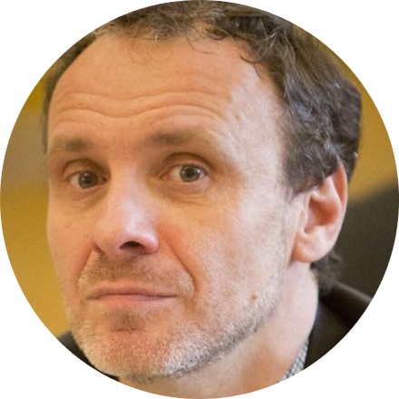
Dr. Stefano Mariani |
Dr. Stefano Mariani received an M.S. degree (cum laude) in civil engineering in 1995, and a Ph.D. degree in structural engineering in 1999; both degrees are from the Polytechnic University of Milan. He is currently an associate professor at the Department of Civil and Environmental Engineering of the Polytechnic University of Milan. He was a research scholar at the Danish Technical University in 1997, an adjunct professor at Penn State University in 2007, and a visiting professor at the Polytechnic Institute of New York University in 2009. He is a member of the Editorial Boards of Algorithms, International Journal on Advances in Systems and Measurements, Inventions, Machines, Micro and Nanosystems, Micromachines, and Sensors. He has been a recipient of the Associazione Carlo Maddalena Prize for graduate students (1996), and of the Fondazione Confalonieri Prize for PhD students (2000). His main research interests are: the reliability of MEMS that are subject to shocks and drops; the structural health monitoring of composite structures through MEMS sensors; numerical simulations of ductile fracture in metals and of quasi-brittle fracture in heterogeneous and functionally graded materials; extended finite element methods; the calibration of constitutive models via extended and sigma-point Kalman filters; and multi-scale solution methods for dynamic delamination in layered composites. |
|
Dr. Francisco Falcone School of Engineering and Sciences, Tecnologico de Monterrey, Mexico |
Dr. Francisco Falcone received his Telecommunication Engineering Degree (1999) and PhD in Communication Engineering (2005), both at the Public University of Navarre in Spain. From 1999 to 2000 he worked as Microwave Commissioning Engineer, Siemens-Italtel. From 2000 to 2008 he worked as Radio Network Engineer, Telefónica Móviles. In 2009 he co-founded Tafco Metawireless. From 2003 to 2009 he was also Assistant Lecturer at UPNA, becoming Associate Professor in 2009. His research area is artificial electromagnetic media, complex electromagnetic scenarios and wireless system analysis, with applications to context aware environments, Smart Cities and Smart Regions. He has over 500 contributions in journal and conference publications. He has been recipient of the CST Best Paper Award in 2003 and 2005, Best PhD in 2006 awarded by the Colegio Oficial de Ingenieros de Telecomunicación, Doctorate award 2004-2006 awarded by UPNA, Juan Lopez de Peñalver Young Researcher Award 2010 awarded by the Royal Academy of Engineering of Spain and Premio Talgo 2012 for Technological Innovation. |
|
Dr. Stefan Bosse |
Dr. Stefan Bosse studied physics at the University of Bremen. He received a PhD/doctoral degree (Dr. rer. nat.) in physics in the year 2002 at the University of Bremen, and the post-doctoral degree (Habilitation) and the Venia Legendi in Computer Science in the year 2016 at the University of Bremen with his habilitation (postdoctoral degree) "Unified Distributed Sensor and Environmental Information Processing with Multi-Agent Systems". Since 2017 he is teaching and researching as a Privatdozent at the University of Bremen, Department of Computer Science, and since 2018 he is an interim professor at the University of Koblenz-Landau, Faculty Computer Science, Institute of Software Technologies. At the University of Bremen and University Koblenz-Landau he teaches several courses in fundamental computer science, functional programming, and in selected advanced topics covering the design and programming of massive parallel and distributed systems, multi-agents systems and agent-based simulation, high-level synthesis of complex digital logic data processing systems, and material-integrated sensing systems with a high interdisciplinary background. His main research area is distributed artificial intelligence in general, and in particular information processing in massive parallel and distributed systems using agent-based approaches combined with machine learning, and agent-based simulation. A broad range of fields of application and domains are addressed: Material Science, Materials Informatics, Smart Materials, IoT, Production Engineering, Social Science, Crowd Sensing, Geo Science. He conducted projects in the internationally recognized ISIS Scientific Centre for Intelligent Sensorial Materials pushing interdisciplinary research closing the gap between technology and computer science, finally joining the ISIS council and publishing an internationally well regarded handbook on this topic. He published about 100 journal and conference papers and acts as a reviewer and a guest editor for several international journals and is a member of a broad range of international conference programme and organizing committees. |
|
Dr. Jean-marc Laheurte |
Dr. Jean-Marc Laheurte received the M.Sc. and Ph.D. degrees in electrical engineering and the Habilitation to Supervise Research from the University of Nice, France, in 1989, 1992 and 1997, respectively. From 1989 to 1990, he was a research assistant at the École Polytechnique Fédérale de Lausanne, Switzerland. In 1992, he was a postdoctoral researcher at the University of Michigan, Ann Arbor, MI, USA. From 1993 to 2002, he was an Associate Professor at the University of Nice Sophia Antipolis, France. Since 2002, he has been a Professor at the University Gustave Eiffel, France. In 2012, he spent a year as a senior RF engineer at Tagsys, La Ciotat, France. For the past 8 years, he has been the director of the 75-member Electronics, SYstèmes de COmmunications and Microsystems Laboratory (ESYCOM Laboratory). He is the author or co-author of two books, two book chapters, more than 80 technical papers in international journals and 90 conference papers. He holds two patents on RFID technologies. His current research interests include antennas in matter, RFID technologies, RFID localization, body array antennas (BANs) and channel modeling. |
Meet the Event Chairs
Important Dates

- Abstract submission deadlineAug 31, 2023
- Abstract acceptance notificationSep 15, 2023
- Full file submission deadlineOct 20, 2023
Meet Our Speakers
- A. Chemo- and Biosensors
- B. Physical Sensors
- C. Sensor Networks, IoT and Structural Health Monitoring
- D. Sensor Data Analytics
- E. Sensors and Artificial Intelligence
Sponsors and Partners
Organizer

Media partner


Live Session 1 (17 November 2023)
Live Session 2 (21 November 2023)
Live Session 3 (23 November 2023)
Live Session 4 (27 November 2023)
Proceedings of the 9th International Electronic Conference on Sensors and Applications (ECSA-9)
Proceedings of the 8th International Electronic Conference on Sensors and Applications (ECSA-8)
Proceedings of the 7th International Electronic Conference on Sensors and Applications (ECSA-7)
Proceedings of the 6th International Electronic Conference on Sensors and Applications (ECSA-6)
Proceedings of the 5th International Electronic Conference on Sensors and Applications (ECSA-5)
Proceedings of the 4th International Electronic Conference on Sensors and Applications (ECSA-4)
Proceedings of the 3rd International Electronic Conference on Sensors and Applications (ECSA-3)
Ms. Doris Dai
Ms. Kellie Wong
E-Mail: ecsa@mdpi.com
Sponsoring Opportunities
For information regarding sponsoring opportunities, please contact the conference secretariat.